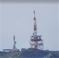
 view gallery view gallery NW3.2 km NW3.2 km
|   Patscherkofel Transmitter Station- Innsbruck, Tirol, Austria Patscherkofel Transmitter Station- Innsbruck, Tirol, Austria
in Satellite Imagery Oddities Sender Patscherkofel bei Innsbruck. posted by:  kaschper69 kaschper69 location: Tirol, Austria date approved: 08/08/2017 last visited: 08/08/2017 |
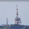 view gallery view galleryNW3.2 km |  Sender Patscherkofel - Innsbruck, Tirol, Austria Sender Patscherkofel - Innsbruck, Tirol, Austria
in Radio and Television Transmitter Towers [DE] Sender Patscherkofel bei Innsbruck.
[EN] A multi-client transmitter tower at Innsbruck. posted by: kaschper69 location: Tirol, Austria date approved: 04/10/2017 last visited: 04/10/2017 |
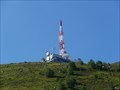 view gallery view galleryNW3.2 km |  Sender Patscherkofel - Patsch, Tyrol, Austria Sender Patscherkofel - Patsch, Tyrol, Austria
in Wikipedia Entries Der Sender Patscherkofel bei Patsch, Austria. posted by: kaschper69 location: Tirol, Austria date approved: 01/18/2021 last visited: 01/18/2021 |
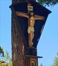 view gallery view gallery N3.2 km N3.2 km
|  Wayside shrine at the Zirbenweg, Tirol - Austria Wayside shrine at the Zirbenweg, Tirol - Austria
in Wayside shrines Shortly after the beginning of the Zirbenweg walk you will pass this Wayside Shrine. posted by:  kallehaugerne kallehaugerne location: Tirol, Austria date approved: 10/02/2022 last visited: never |
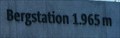 view gallery view galleryNW3.9 km |  1965m - Patscherkofelbahn Bergstation - Patsch, Tyrol, Austria 1965m - Patscherkofelbahn Bergstation - Patsch, Tyrol, Austria
in Elevation Signs Elevation sign at the Patscherkofelbahn mountain station. posted by: kaschper69 location: Tirol, Austria date approved: 02/01/2021 last visited: 01/21/2021 |
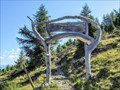 view gallery view galleryNW3.9 km |  Arch Zirbenweg - Tulfes, Tyorl, Austria Arch Zirbenweg - Tulfes, Tyorl, Austria
in Freestanding Arches Freestanding arch at the entrance of the stone pine path above Tulfes. posted by: kaschper69 location: Tirol, Austria date approved: 01/18/2021 last visited: 01/18/2021 |
 view gallery view gallery NE4.3 km NE4.3 km
| Glungezerhütte, Tirol - Austria 2600 m in Elevation Signs This sign is mounted at the left side of the front door of the Glungezerhütte in the Tiroler Alps. Is says 2600 meters above sea level, but the correct height is 2610 meters. posted by: kallehaugerne location: Tirol, Austria date approved: 10/04/2022 last visited: never |
 view gallery view galleryNE4.3 km |  Glungezerhütte, Tirol - Austria Glungezerhütte, Tirol - Austria
in Lodge-Style Accommodations The Glungezerhütte is a mountain hut of the Austrian Alpine Club in the Tux Alps in the Austrian state of Tirol. The hut is at 2610 m above sea leve, at the saddle between the Glungezer summit and the Sonnenspitze. posted by: kallehaugerne location: Tirol, Austria date approved: 10/05/2022 last visited: 06/25/2023 |
 view gallery view galleryNE4.3 km | Glungezerhütte, Tirol - Austria in Wikipedia Entries The Glungezerhütte is a mountain hut of the Austrian Alpine Club in the Tux Alps in the Austrian state of Tirol. The hut is at 2610 m above sea leve, at the saddle between the Glungezer summit and the Sonnenspitze. posted by: kallehaugerne location: Tirol, Austria date approved: 10/04/2022 last visited: never |
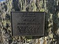
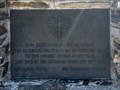 view gallery view galleryNE4.3 km |  British-Eagle-Flug 802 - Tirol, Austria British-Eagle-Flug 802 - Tirol, Austria
in Plane Crash Sites A crash site memorialized by a cross and plaque. posted by: flyingmoose location: Tirol, Austria date approved: 03/09/2024 last visited: never |
 view gallery view galleryNE4.3 km |  Memorial Cross - Tirol, Austria Memorial Cross - Tirol, Austria
in Christian Crosses Cross on top of Glungezer Mountain. posted by: flyingmoose location: Tirol, Austria date approved: 03/09/2024 last visited: never |
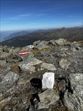 view gallery view galleryNE4.3 km |  TP 72-148 (GLUNGEZER) - Tirol, Austria TP 72-148 (GLUNGEZER) - Tirol, Austria
in Public Land Survey Marks Benchmark at the peak of Glungezer. posted by: flyingmoose location: Tirol, Austria date approved: 03/12/2024 last visited: never |
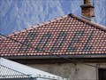 view gallery view gallery SW5.3 km SW5.3 km
|  RODEL - Mühlbachl, Tirol, Austria RODEL - Mühlbachl, Tirol, Austria
in Readable From Above Schriftzug "RODEL" auf einer Dachseite des Hauses des Rodelherstellers Gasser am Zieglstadt 15 in 6143 Mühlbachl . posted by: kaschper69 location: Tirol, Austria date approved: 09/11/2019 last visited: 09/11/2019 |
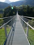 view gallery view gallery S5.3 km S5.3 km
|  Suspension bridge Schloss Matrei-Trautson - Mühlbachl, Tyrol, Austria Suspension bridge Schloss Matrei-Trautson - Mühlbachl, Tyrol, Austria
in Pedestrian Suspension Bridges Hängeseilbrücke zwischen den Orten Mühlbachl und Pfons in Tirol. posted by: kaschper69 location: Tirol, Austria date approved: 09/22/2021 last visited: 09/22/2021 |
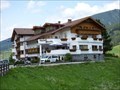 view gallery view gallerySW5.5 km |  Hotel Stolz - Matrei am Brenner, Tyrol, Austria Hotel Stolz - Matrei am Brenner, Tyrol, Austria
in Dog Friendly Hotels Hotel Stolz is a dog-friendly hotel in Matrei am Brenner, Tyrol. posted by: kaschper69 location: Tirol, Austria date approved: 10/01/2019 last visited: 10/01/2019 |
 view gallery view gallerySW5.5 km | Restaurant Stolz - Matrei am Brenner, Tirol, Austria in Dog-Friendly Restaurants Restaurant Stolz is a dog-friendly restaurant in Matrei am Brenner, Tyrol. posted by: kaschper69 location: Tirol, Austria date approved: 10/01/2019 last visited: 10/01/2019 |
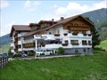 view gallery view gallerySW5.5 km |  Hotel Stolz - Matrei am Brenner, Tirol, Austria Hotel Stolz - Matrei am Brenner, Tirol, Austria
in Recommended Accommodation Hotel Stolz in Matrei am Brenner. posted by: kaschper69 location: Tirol, Austria date approved: 04/06/2017 last visited: 04/06/2017 |
 view gallery view galleryNE5.5 km |  Michael Wirtenberger - Tirrol, Austria Michael Wirtenberger - Tirrol, Austria
in Citizen Memorials Memorial for a Snowboarder who died in 1999. posted by: flyingmoose location: Tirol, Austria date approved: 03/09/2024 last visited: never |
 view gallery view gallerySW5.5 km |  Sundial Matrei am Brenner, Tirol, Austria Sundial Matrei am Brenner, Tirol, Austria
in Sundials [DE] Sonnenuhr in Matrei am Brenner, Tirol.
[EN] Sundial at Matrei am Brenner, Tirol. posted by: kaschper69 location: Tirol, Austria date approved: 08/27/2016 last visited: 08/25/2016 |
 view gallery view gallerySW5.6 km |  Parish church Matrei am Brenner, Tyrol, Austria Parish church Matrei am Brenner, Tyrol, Austria
in Medieval Churches Parish church of the Assumption in Matrei am Brenner. posted by: kaschper69 location: Tirol, Austria date approved: 12/01/2018 last visited: 12/01/2018 |
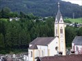 view gallery view gallerySW5.6 km |  Pfarrkirche Matrei am Brenner, Tirol, Austria Pfarrkirche Matrei am Brenner, Tirol, Austria
in This Old Church Parish of the Assumption in Matrei am Brenner. posted by: kaschper69 location: Tirol, Austria date approved: 09/30/2016 last visited: 09/30/2016 |
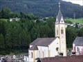 view gallery view gallerySW5.6 km |  Pfarrkirche Matrei am Brenner, Tyrol, Austria Pfarrkirche Matrei am Brenner, Tyrol, Austria
in Unique Steeples Parish church of the Assumption with a unique steeple in Matrei am Brenner. posted by: kaschper69 location: Tirol, Austria date approved: 12/01/2018 last visited: 12/01/2018 |
 view gallery view gallerySW5.6 km |  Bell tower Pfarrkirche Matrei am Brenner, Tyrol, Austria Bell tower Pfarrkirche Matrei am Brenner, Tyrol, Austria
in Bell Towers Parish church of the Assumption with a bell tower in Matrei am Brenner. posted by: kaschper69 location: Tirol, Austria date approved: 12/01/2018 last visited: 12/01/2018 |
 view gallery view gallerySW5.6 km |  Church clock Pfarrkirche Matrei am Brenner, Tirol, Austria Church clock Pfarrkirche Matrei am Brenner, Tirol, Austria
in Town Clocks At the church clock of the parish church in Matrei am Brenner is a working clock mounted to the tower. posted by: kaschper69 location: Tirol, Austria date approved: 09/30/2016 last visited: 09/29/2016 |
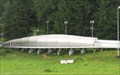 view gallery view galleryNW6 km | Innsbruck Olympic Sliding Centre - Igls, Austria in Satellite Imagery Oddities The Innsbruck Olympic Sliding Centre is located in Igls, Austria (southeast of Innsbruck). posted by: denben location: Tirol, Austria date approved: 12/06/2017 last visited: never |
|