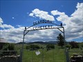
 view gallery view gallery W1 km W1 km
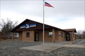
|   Dearborn/Craig Northbound Rest Area Dearborn/Craig Northbound Rest Area
in 'You Are Here' Maps You Are Here at the Dearborn/Craig Rest Area on the southeast side of Interstate Highway 15 just west of Exit 240, near the small towns of Dearborn and Craig, Montana. posted by:  brwhiz brwhiz location: Montana date approved: 12/25/2012 last visited: 06/15/2024 |
 view gallery view gallery E2.3 km E2.3 km
|  Gary Cooper Bridge South Camera - Craig, MT Gary Cooper Bridge South Camera - Craig, MT
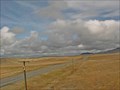
in Web Cameras This is one of 73 (as of January 2017) Road Weather Information System camera sites operated by the Montana Department of Transportation to aid motorists as they make their way across BIG SKY Country. posted by: T0SHEA location: Montana date approved: 01/27/2017 last visited: never |
 view gallery view galleryE2.3 km | Gary Cooper Bridge Roadway Camera - Craig, MT in Web Cameras This is one of 73 (as of January 2017) Road Weather Information System camera sites operated by the Montana Department of Transportation to aid motorists as they make their way across BIG SKY Country. posted by: T0SHEA location: Montana date approved: 01/27/2017 last visited: never |
 view gallery view galleryE2.4 km | Gary Cooper Bridge North Camera - Craig, MT in Web Cameras This is one of 73 (as of January 2017) Road Weather Information System camera sites operated by the Montana Department of Transportation to aid motorists as they make their way across BIG SKY Country. posted by: T0SHEA location: Montana date approved: 01/27/2017 last visited: never |
 view gallery view gallery NE5.6 km NE5.6 km
|  The Untouchables 1987 The Untouchables 1987
in Movie Locations Crossing the bridge from Canada posted by: ZenPanda location: Montana date approved: 06/03/2007 last visited: 07/04/2009 |
 view gallery view gallery SW15.6 km SW15.6 km
|  The Mann Gulch Fire The Mann Gulch Fire
in Famous Fires Wildfire turned deadly when smokejumpers panicked. posted by: ZenPanda location: Montana date approved: 08/31/2007 last visited: 08/31/2007 |
 view gallery view gallerySW15.6 km |  The Mann Gulch Fire The Mann Gulch Fire
in Montana Historical Markers Dedicated to the 13 men killed near Holter Lake in 1949. posted by: ZenPanda location: Montana date approved: 08/29/2007 last visited: 08/28/2007 |
 view gallery view gallerySW15.9 km |  Holter Bridge Montana Holter Bridge Montana
in Truss Bridges Bridge spanning the Missouri River near Holter Dam posted by: ZenPanda location: Montana date approved: 09/01/2007 last visited: 09/01/2007 |
 view gallery view gallerySW19.6 km |  Wolf Creek Montana 59648 Wolf Creek Montana 59648
in U.S. Post Offices Older building but new signage posted by: ZenPanda location: Montana date approved: 08/28/2007 last visited: 05/22/2011 |
 view gallery view gallerySW19.8 km |  Wolf Creek Hotel - Wolf Creek, MT Wolf Creek Hotel - Wolf Creek, MT
in U.S. National Register of Historic Places A hotel for over a century, the Wolf Creek Hotel was one of the first businesses to open in the then new town of Wolf Creek. posted by: T0SHEA location: Montana date approved: 09/10/2017 last visited: never |
 view gallery view gallerySW19.8 km | Wolf Creek Hotel - Wolf Creek, MT in Montana Historical Markers A hotel for over a century, the Wolf Creek Hotel was one of the first businesses to open in the then new town of Wolf Creek. posted by: T0SHEA location: Montana date approved: 09/09/2017 last visited: never |
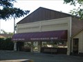
 view gallery view galleryNE20.4 km | Cascade, Montana 59421 in U.S. Post Offices Small town Montana PO posted by: ZenPanda location: Montana date approved: 03/22/2008 last visited: 06/19/2011 |
 view gallery view galleryNE20.9 km |  Wedsworth Memorial Library- Cascade, Montana Wedsworth Memorial Library- Cascade, Montana
in Libraries Small town library posted by: ZenPanda location: Montana date approved: 09/01/2007 last visited: 11/30/2008 |
 view gallery view galleryNE21.7 km |  American Legion Veteran's Memorial Cascade MT American Legion Veteran's Memorial Cascade MT
in Non-Specific Veteran Memorials Wall dedicated to all Montana War veterans posted by: ZenPanda location: Montana date approved: 06/20/2007 last visited: 11/30/2008 |
 view gallery view galleryNE22 km |  Hillside Cemetery Cascade Montana USA Hillside Cemetery Cascade Montana USA
in Worldwide Cemeteries Very small cemetery on the side of a hill. Near veterans' memorial posted by: ZenPanda location: Montana date approved: 06/21/2007 last visited: 11/30/2008 |
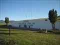
 view gallery view gallerySW25.9 km | The Central Montana Railroad (South bound) in Montana Historical Markers Identical to the Northbound sign. posted by: ZenPanda location: Montana date approved: 07/19/2008 last visited: 06/19/2018 |
 view gallery view gallerySW26.1 km | Central Montana Railroad in Montana Historical Markers Located at a rest stop along I 15 northbound. posted by: ZenPanda location: Montana date approved: 10/02/2007 last visited: 06/19/2018 |
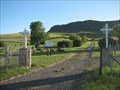
 view gallery view galleryW26.2 km | Dearborn Cemetery - Wolf Creek, Montana in Worldwide Cemeteries Dearborn Cemetery is north of Wolf Creek about 24 km on Hwy. 434. Also at this location is the historic Dearborn Memorial Chapel. posted by: T0SHEA location: Montana date approved: 02/02/2018 last visited: never |
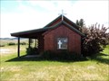 view gallery view galleryW26.2 km |  Burggraff - Wolf Creek, Montana Burggraff - Wolf Creek, Montana
in Citizen Memorials Mr. & Mrs. Peter Burggraff and Mr. & Mrs. Adolf Burggraff plaque is by the entrance to the Dearborn Memorial Chapel next to the Dearborn Cemetery. posted by: T0SHEA location: Montana date approved: 02/06/2018 last visited: never |
 view gallery view gallery NW26.7 km NW26.7 km
| Bowmans Webcam - Wolf Creek, M in Web Cameras This is one of 73 (as of January 2017) Road Weather Information System cameras operated by the Montana Department of Transportation to aid motorists as they make their way across BIG SKY Country. posted by: T0SHEA location: Montana date approved: 01/11/2017 last visited: never |
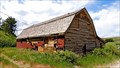 view gallery view galleryW30.6 km | Stearns Hall - Wolf Creek, MT in U.S. National Register of Historic Places On Highway 434 2 miles North of the junction with Highway 200, few people will ever stumble across this one time community hall. posted by: T0SHEA location: Montana date approved: 07/07/2017 last visited: never |
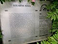 view gallery view galleryW30.6 km | Stearns Hall - Wolf Creek, MT in Montana Historical Markers On Highway 434 2 miles North of the junction with Highway 200, few people will ever stumble across this one time community hall. posted by: T0SHEA location: Montana date approved: 07/08/2017 last visited: never |
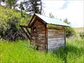 view gallery view galleryW30.6 km |  Stearns Hall - Wolf Creek, MT Stearns Hall - Wolf Creek, MT
in Outhouses On Highway 434 2 miles North of the junction with Highway 200, few people will ever stumble across this one time community hall or its little outhouse. posted by: T0SHEA location: Montana date approved: 07/07/2017 last visited: never |
 view gallery view gallerySW32 km | Sieben Web Camera - Sieben, MT in Web Cameras This is one of 73 (as of February 2017) Road Weather Information System camera sites operated by the Montana Department of Transportation to aid motorists as they make their way across BIG SKY Country. posted by: T0SHEA location: Montana date approved: 02/09/2017 last visited: never |
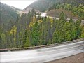 view gallery view galleryW37 km | Roger's Pass South Web Camera - Lincoln, MT in Web Cameras This is one of 73 (as of February 2017) Road Weather Information System camera sites operated by the Montana Department of Transportation to aid motorists as they make their way across BIG SKY Country. posted by: T0SHEA location: Montana date approved: 02/16/2017 last visited: never |
|