 view gallery view gallery NE1.4 km NE1.4 km
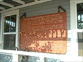
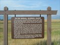
|   Big Blackfoot Railroad (at original spot) Big Blackfoot Railroad (at original spot)
in Montana Historical Markers Similar to the one in Ovando but this is the original placement. posted by:  ZenPanda ZenPanda location: Montana date approved: 08/29/2007 last visited: 09/19/2014 |
 view gallery view gallery SW14.2 km SW14.2 km
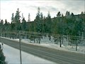
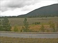
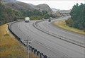
|  Greenough Hill Camera - Greenough, MT Greenough Hill Camera - Greenough, MT
in Web Cameras This is one of 73 (as of January 2017) Road Weather Information System camera sites operated by the Montana Department of Transportation to aid motorists as they make their way across BIG SKY Country. posted by: T0SHEA location: Montana date approved: 01/27/2017 last visited: never |
 view gallery view gallery N18.2 km N18.2 km
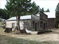
|  Seeley Lake Historic Museum Seeley Lake Historic Museum
in History Museums A local museum with displays in the stalls of an old barn. posted by:  Ramblin Ron Ramblin Ron location: Montana date approved: 02/27/2008 last visited: never |
 view gallery view gallery E18.7 km E18.7 km
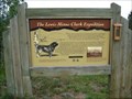
|  Lewis without Clark - Blackfoot River Valley - Ovando, MT Lewis without Clark - Blackfoot River Valley - Ovando, MT
in Lewis and Clark Trail After splitting the expedition into two parties at Travler's Rest, Clark continued back along the Bitteroot River, while Lewis ventured north along the Blackfoot River. posted by: CerealBoxMonsters location: Montana date approved: 10/31/2009 last visited: 10/12/2013 |
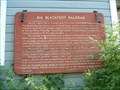 view gallery view galleryE18.8 km | Big Blackfoot Railroad in Montana Historical Markers Historical marker commemorating the Big Blackfoot Railroad, a railroad built to service the logging industry in Montana. posted by:  BruceS BruceS location: Montana date approved: 08/29/2007 last visited: 04/03/2022 |
 view gallery view galleryE18.8 km |  Ovando, Montana Ovando, Montana
in American Guide Series Ovando is a small town in central Montana. posted by: BruceS location: Montana date approved: 02/03/2008 last visited: never |
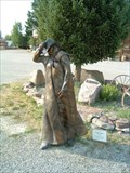 view gallery view galleryE18.8 km |  Damn Wind by JR Eason - Ovando, Montana Damn Wind by JR Eason - Ovando, Montana
in Figurative Public Sculpture Sculpture of a cowboy walking in the wind. posted by: BruceS location: Montana date approved: 08/29/2007 last visited: 08/29/2009 |
 view gallery view galleryE18.8 km |  Ovando's Douglas Fir - Ovando, MT Ovando's Douglas Fir - Ovando, MT
in Exceptional Tree Growth Ring Displays Located outside of Ovando's Historical Museum, this Douglas Fir dates all the way back to 1483. posted by: CerealBoxMonsters location: Montana date approved: 10/06/2009 last visited: 10/12/2013 |
 view gallery view galleryE18.8 km | Bob Marshall Wilderness Country ("The Bob") #2 in Montana Historical Markers Historical marker commemorating the Bob Marshal Wilderness located at the Brand Bar Museum in Ovando, Montana. posted by: BruceS location: Montana date approved: 08/29/2007 last visited: 08/29/2009 |
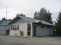 view gallery view galleryE18.8 km |  Ovando Montana 59854 Ovando Montana 59854
in U.S. Post Offices Small PO in another Montana small town filled with great history posted by: ZenPanda location: Montana date approved: 08/28/2007 last visited: 11/05/2014 |
 view gallery view gallery S19.6 km S19.6 km
|  Garnet Ghost Mining Town, MT Garnet Ghost Mining Town, MT
in Ghost Towns The Bureau of Land Management and the Garnet Preservation Association work together to preserve many original buildings, including the stately Wells Hotel, for posterity. Behind the scenes at Garnet, workers stabilize the old buildings to keep them from falling down. The goal is to retain the ghostly nature of the abandoned buildings while preserving the roofs from caving in and the walls from giving away.
posted by: SeabeckTribe location: Montana date approved: 05/03/2006 last visited: 09/06/2019 |
 view gallery view galleryN21.1 km | Seeley Lake, Montana 59868 in U.S. Post Offices Lakeside town in rural Montana. posted by: ZenPanda location: Montana date approved: 08/11/2007 last visited: 08/29/2014 |
 view gallery view gallery NW23 km NW23 km
|  Tamaracks Resort Tamaracks Resort
in Chalet, Cottage, and Cabin Style Lodging Tamaracks Resort offers 17 fully furnished individual cabins with full kitchens, and 14 campsites right on Seeley Lake in North-Western Montana. The resort is perfect for family reunions, weddings, retreats, and special get-away's. Open all year. posted by: tamaracks resort location: Montana date approved: 02/25/2009 last visited: never |
 view gallery view galleryNW23.3 km |  Camp Paxson Boy Scout Camp (24MO77) Camp Paxson Boy Scout Camp (24MO77)
in U.S. National Register of Historic Places A historic boy scout camp now used by numerous types of groups located on the shore of Seeley Lake. posted by: Ramblin Ron location: Montana date approved: 05/07/2008 last visited: 08/03/2014 |
 view gallery view galleryE26.9 km | Bob Marshall Wilderness Country in Montana Historical Markers Marker commemorating the creation of the huge Bob Marshall Wilderness in Montana. posted by: BruceS location: Montana date approved: 08/28/2007 last visited: 08/29/2009 |
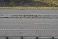
 view gallery view galleryE30.7 km | Helmville Camera - Ovando, MT in Web Cameras This is one of 73 (as of January 2017) Road Weather Information System camera sites operated by the Montana Department of Transportation to aid motorists as they make their way across BIG SKY Country. posted by: T0SHEA location: Montana date approved: 01/27/2017 last visited: never |
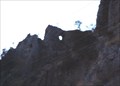 view gallery view galleryS31.5 km |  Unnamed MT Arch Unnamed MT Arch
in Natural Arches While taking several geology classes I was lucky enough to accompany a field trip to this location. It is on private property but is visible from the roadway. posted by: Jennifer&Dean location: Montana date approved: 11/18/2005 last visited: 08/24/2009 |
 view gallery view galleryS32 km | Bearmouth Southwest Webcam - Drummond, MT in Web Cameras This is one of 73 (as of January 2017) Road Weather Information System cameras operated by the Montana Department of Transportation to aid motorists as they make their way across BIG SKY Country. posted by: T0SHEA location: Montana date approved: 01/10/2017 last visited: never |
 view gallery view galleryS32 km | Bearmouth East Webcam - Drummond, MT in Web Cameras This is one of 73 (as of January 2017) Road Weather Information System cameras operated by the Montana Department of Transportation to aid motorists as they make their way across BIG SKY Country. posted by: T0SHEA location: Montana date approved: 01/10/2017 last visited: never |
 view gallery view galleryS32 km | Bearmouth Roadway Webcam - Drummond, MT in Web Cameras This is one of 73 (as of January 2017) Road Weather Information System cameras operated by the Montana Department of Transportation to aid motorists as they make their way across BIG SKY Country. posted by: T0SHEA location: Montana date approved: 01/10/2017 last visited: never |
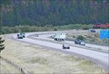 view gallery view galleryS32 km | Bearmouth SE S-curve Webcam - Drummond, MT in Web Cameras This is one of 73 (as of January 2017) Road Weather Information System cameras operated by the Montana Department of Transportation to aid motorists as they make their way across BIG SKY Country. posted by: T0SHEA location: Montana date approved: 01/10/2017 last visited: never |
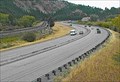
 view gallery view galleryS33.2 km |  Bear Mouth Rest Area, Interstate I-90 EB, Montana Bear Mouth Rest Area, Interstate I-90 EB, Montana
in Highway Rest Areas This is a pleasant stop on Interstate I-90, east of Missoula, Montana (near Drummond). posted by: Queens Blessing location: Montana date approved: 10/18/2010 last visited: 08/28/2018 |
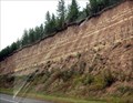 view gallery view galleryS33.2 km |  Madison Limestone and the Garnet Mountains, Montana Madison Limestone and the Garnet Mountains, Montana
in Places of Geologic Significance This geological feature is highlighted by the State of Montana with a special informative road sign. posted by: Queens Blessing location: Montana date approved: 10/16/2010 last visited: 08/28/2018 |
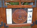
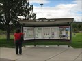
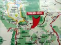 view gallery view galleryS33.2 km |  Piltner Scenic Route wayside, Montana Piltner Scenic Route wayside, Montana
in 'You Are Here' Maps There are TWO "You Are Here" Maps on this display panel in the Bear Mouth Rest Area, east of Missoula and west of Drummond, MT. posted by: Queens Blessing location: Montana date approved: 10/16/2010 last visited: 09/02/2013 |
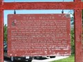 view gallery view galleryS33.2 km | Bear Mouth Historical Marker in Montana Historical Markers Bear Mouth Historical Marker. posted by: tsunrisebey location: Montana date approved: 06/25/2008 last visited: 09/20/2010 |
|