 view gallery view gallery SW16.6 km SW16.6 km
|   Barrage Kipawa Barrage Kipawa
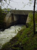
in Water Dams Le Barrage Kipawa sert à régulariser le niveau du lac Kipawa.
The Kipawa Dam serves to regulate the level of Lake Kipawa. posted by:  caius caius location: Québec, Canada date approved: 05/28/2009 last visited: never |
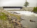 view gallery view gallerySW20.3 km | Barrage Tee in Water Dams Le Barrage du lac Tee a été construit en 2006 pour régulariser le niveau des eaux du lac Tee.
The Tee Lake Dam was built in 2006 to regulate the water level of Lake Tee. posted by: caius location: Québec, Canada date approved: 05/24/2009 last visited: never |
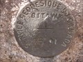
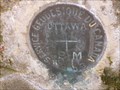
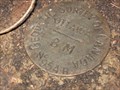
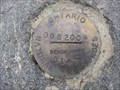
 view gallery view gallerySW24.8 km |  Transport Québec 93 KS Z 53 Transport Québec 93 KS Z 53
in Canadian Benchmarks Situé à l'est de la voie de contournement de la ville de Témiscaming.
Located east of the bypass of the town of Temiscaming. posted by: caius location: Québec, Canada date approved: 05/31/2009 last visited: never |
 view gallery view gallerySW26.4 km | Barrage Lumsden in Water Dams Construit en 1918 pour alimenter l'usine de Pâte et papier de la Riordon pulp & paper ainsi que la ville de Témiscaming.
Built in 1918 to feed the pulp and paper in the Riordon Pulp & paper, and the city of Temiscaming. posted by: caius location: Québec, Canada date approved: 05/24/2009 last visited: never |
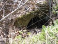
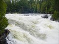
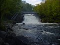 view gallery view gallerySW27.2 km |  Chute Gordon Chute Gordon
in Waterfalls Situé sur le ruisseau Gordon qui relie le Lac Kipawa au lac Témiscamingue.
Located on the Gordon Creek which connects Lake Kipawa to Lake Timiskaming. posted by: caius location: Québec, Canada date approved: 05/31/2009 last visited: never |
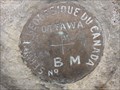
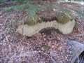
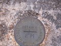
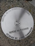 view gallery view gallerySW27.2 km | Special Purpose BM in Temiscaming Quebec in Canadian Benchmarks One of Canada 200 or so High Definition Network Geodetic monuments located at top of hill of highway 101 leading out of Temiscaming. posted by: bandsaw1 location: Québec, Canada date approved: 05/07/2010 last visited: never |
 view gallery view gallerySW27.5 km |  Témiscaming BL 5.5 inch MkIII Témiscaming BL 5.5 inch MkIII
in Static Artillery Displays BL 5.5inch Medium Gun MkIII de la place des vétérans dans la ville de Témiscaming au Québec.
BL 5.5inch Medium Gun MkIII on Veterans place in Témiscaming, Québec posted by: caius location: Québec, Canada date approved: 06/03/2009 last visited: never |
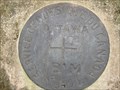
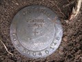
 view gallery view gallerySW27.8 km | CPR MP 33.60 Temiscaming Sub in Canadian Benchmarks Geodetic Vertical Benchmark located at MP 33.60 on the CPR Temiscaming Sub posted by: bandsaw1 location: Québec, Canada date approved: 04/15/2010 last visited: never |
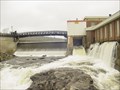
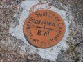
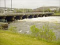 view gallery view gallerySW28.3 km | Barrage Temiscaming in Water Dams Situé sur la frontière Québec-Ontario, sur le cours de l'Outaouais supérieure.
Located on the Ontario-Quebec border, on the upper Ottawa River. posted by: caius location: Québec, Canada date approved: 05/24/2009 last visited: never |
 view gallery view gallerySW28.8 km | MP 39.04 CPR Temiscaming Sub in Canadian Benchmarks Geodetic Vertical Benchmark located at Mile Post 39.04 Temiscaming Sub on the CPR Line posted by: bandsaw1 location: Québec, Canada date approved: 04/15/2010 last visited: never |
 view gallery view gallerySW29 km | CPR MP 37.08 Temiscaming Sub in Canadian Benchmarks Geodetic Vertical Bench Mark located at Mile Post 37.08 on the CPR Temiscaming Sub posted by: bandsaw1 location: Québec, Canada date approved: 04/15/2010 last visited: never |
 view gallery view gallerySW29.9 km | MP 31.18 CPR Temiscaming Sub in Canadian Benchmarks Geodetic Vertical Benchmark located at Mile Post 31.18 CPR Temiscaming Sub posted by: bandsaw1 location: Québec, Canada date approved: 04/15/2010 last visited: never |
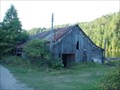 view gallery view gallery W30.4 km W30.4 km
|  Opémican Opémican
in Unoccupied Buildings, Shacks, and Cabins Opémican sur le lac Témiscamingue
Opemican on Lake Temiscaming posted by: caius location: Québec, Canada date approved: 09/06/2009 last visited: never |
 view gallery view gallerySW31.5 km | CPR MP 28.94 Temiscaming Sub in Canadian Benchmarks Geodetic Vertical Bench Mark located at Mile 28.94 CPR Temiscaming Sub posted by: bandsaw1 location: Québec, Canada date approved: 04/15/2010 last visited: never |
 view gallery view gallery S37.3 km S37.3 km
| CPR MP 23.00 Temiscaming Sub in Canadian Benchmarks Geodetic Vertical Bench Mark located at Mile Post 23.00 CPR Temiscaming Sub. posted by: bandsaw1 location: Québec, Canada date approved: 07/30/2013 last visited: never |
 view gallery view galleryS37.3 km | CPR Mile 23.00 Temiscaming Sub in Canadian Benchmarks Geodetic Vertical Benchmark located on the CPR Temiscaming Sub at Milepost 23.00 posted by: bandsaw1 location: Québec, Canada date approved: 04/18/2010 last visited: never |
 view gallery view galleryS39.3 km | CPR MP 18.85 Temiscaming Sub in Canadian Benchmarks Geodetic Vertical Benchmark located at Mile Post 18.85 CPR Temiscaming Sub posted by: bandsaw1 location: Québec, Canada date approved: 04/15/2010 last visited: never |
 view gallery view galleryS40.4 km | CPR Mile 16.97 Temiscaming Sub in Canadian Benchmarks Geodetic Vertical Benchmark located on the CPR Temiscaming Sub at MP 16.97 posted by: bandsaw1 location: Québec, Canada date approved: 04/18/2010 last visited: never |
 view gallery view galleryS41.5 km | Horizontal Control - Midway along MTO Highway 533 in Canadian Benchmarks Horizontal Control for MTO Highway 533 located in a graval pit halfway between Mattawa and Highway 63 along Highway 533 posted by: bandsaw1 location: Ontario, Canada date approved: 05/07/2010 last visited: never |
 view gallery view gallerySW43.9 km | Horizontal Control - Top End of MTO Highway 533 in Canadian Benchmarks Horizontal Control located toward the top end of Highway 533 near Highway 63. posted by: bandsaw1 location: Ontario, Canada date approved: 05/07/2010 last visited: never |
 view gallery view galleryS44.7 km | CPR Mile 12.50 Temiscaming Sub in Canadian Benchmarks Geodetic Vertical Benchmark located on the CPR Temiscaming Sub on the Bridge at Mile Post 12.50 posted by: bandsaw1 location: Québec, Canada date approved: 04/18/2010 last visited: never |
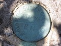 view gallery view galleryS47.3 km | CPR Mile 10.92 Temiscaming Sub in Canadian Benchmarks Geodetic Vertical Benchmark located on the CPR Temiscaming Sub at Mile post 10.92 posted by: bandsaw1 location: Québec, Canada date approved: 04/18/2010 last visited: never |
 view gallery view galleryS48.4 km | BM on MTO Highway 530 - Near Mattawa in Canadian Benchmarks GPS Horizontal Control located along Highway 530 outside of Mattawa. posted by: bandsaw1 location: Ontario, Canada date approved: 05/07/2010 last visited: never |
 view gallery view galleryS48.6 km | CPR Mile 9.13 Temiscaming Sub in Canadian Benchmarks Geodetic Vertical Benchmark located at mile 9.13 CPR Temiscaming Sub posted by: bandsaw1 location: Québec, Canada date approved: 04/18/2010 last visited: never |
 view gallery view gallery NW49.7 km NW49.7 km
| La Grande Chute in Waterfalls La Grande Chute, aussi connue sous le nom de chute Topping.
The Grande Chute, also know as Topping Fall. posted by: caius location: Québec, Canada date approved: 06/03/2009 last visited: 09/18/2010 |
|