 view gallery view gallery N2.1 km N2.1 km
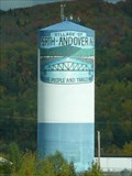
|   Perth-Andover Watertower Perth-Andover Watertower
in Water Towers This very colourful water tower is just East of Hwy 2 near Perth-Andover, New Brunswick. posted by:  PeterNoG PeterNoG location: New Brunswick, Canada date approved: 05/29/2010 last visited: 04/21/2016 |
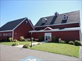
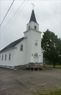 view gallery view galleryN7.1 km |  Our Lady of Mercy Catholic Church in Aroostook, New Brunswick Our Lady of Mercy Catholic Church in Aroostook, New Brunswick
in Roman Catholic Churches Our Lady of Mercy Catholic Church, Aroostook, New Brunswick posted by:  marchanddeboeufs marchanddeboeufs location: New Brunswick, Canada date approved: 04/16/2014 last visited: 06/03/2012 |
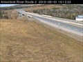 view gallery view galleryN9.7 km |  Aroostook River Highway Webcam - Aroostook, NB Aroostook River Highway Webcam - Aroostook, NB
in Web Cameras The province of New Brunswick operates a network of highway webcams throughout the province to aid motorists in avoiding blizzards, downpours and any other nasty phenomena Mother Nature may have up her sleeve. posted by: T0SHEA location: New Brunswick, Canada date approved: 05/01/2015 last visited: never |
 view gallery view galleryN10.1 km |  Four Falls, New Brunswick Four Falls, New Brunswick
in Waterfalls Four Falls is a series of waterfalls formed by the Limestone Stream as it cascades wildly into the Aroostook River. posted by: Team Goju location: New Brunswick, Canada date approved: 09/30/2011 last visited: 07/24/2016 |
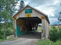 view gallery view gallery NE17.4 km NE17.4 km
|  Tomlinson Mill Bridge Tomlinson Mill Bridge
in Covered Bridges A nice little covered bridge in western New Brunswick. They keep their bridges well maintained. posted by: CoveredBridgeGuy location: New Brunswick, Canada date approved: 03/18/2007 last visited: 08/29/2017 |
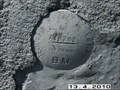 view gallery view galleryN20.9 km |  BENCHMARK# 71B203 BENCHMARK# 71B203
in Canadian Benchmarks ST. PATRICK'S CHURCH (1953) ON EAST SIDE OF TRANS CANADA HIGHWAY, 15.9 KM SOUTH OF BRIDGE OVER SAINT JOHN RIVER, 0.3 KM SOUTH OF JUNCTION WITH OF HIGHWAY NO. 375 (TO GILLESPIE SETTLEMENT), 100 M NORTH OF SIDE ROAD TO LIMESTONE SIDING, TABLET IN SOUTH SIDE CONCRETE FOUNDATION WALL, 3.50 M FROM SOUTHWEST FRONT CORNER OF NEW ADDITION, 18 CM BELOW STONE WALL, 1.5 M ABOVE HIGHWAY LEVEL. posted by: Firefighter001 location: New Brunswick, Canada date approved: 05/02/2010 last visited: 05/07/2010 |
 view gallery view galleryN22.2 km | BENCHMARK # 71B204 in Canadian Benchmarks DEPARTMENT OF HIGHWAYS DEPOT (DISTRICT 11, DIVISION 2, GRAND FALLS), ON EAST SIDE OF TRANS CANADA HIGHWAY, 14.8 KM SOUTH OF BRIDGE OVER SAINT JOHN RIVER, 0.9 KM NORTH OF JUNCTION WITH OF HIGHWAY NO. 375 (TO GILLESPIE SETTLEMENT), TABLET IN WEST SIDE CONCRETE FOUNDATION WALL, 30 CM FROM SOUTHWEST CORNER, 85 CM BELOW SIDING, AT ROAD LEVEL posted by: Firefighter001 location: New Brunswick, Canada date approved: 05/02/2010 last visited: never |
 view gallery view gallery W22.2 km W22.2 km
|  Mustard Fields - Presque Isle ME Mustard Fields - Presque Isle ME
in Flower Fields In July the mustard fields are in bloom and it is like looking out over a sea of yellow. Unbelievable site posted by: nomadwillie location: Maine date approved: 11/13/2009 last visited: 07/20/2009 |
 view gallery view gallery SW22.9 km SW22.9 km
|  Edward C. Dahlgren-Mars Hill, ME Edward C. Dahlgren-Mars Hill, ME
in Medal Of Honor Resting Places World War II Medal of Honor Recipient for action at Oberhoffen, France on February 11, 1945. He is buried in Pierce Cemetery, Mars Hill, ME. posted by: Don.Morfe location: Maine date approved: 11/01/2017 last visited: 12/19/2021 |
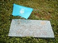
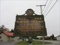 view gallery view galleryW22.9 km |  U.S. Route 1 - Caribou, Maine U.S. Route 1 - Caribou, Maine
in Blue Star Memorial Highway Markers This Blue Star Memorial Highway marker is located along side of U.S. Route 1 in Caribou, Maine. It is near the intersection of Hogan Road and State Street. posted by: UMainah location: Maine date approved: 11/05/2014 last visited: 10/16/2014 |
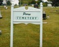 view gallery view gallerySW22.9 km |  Pierce Cemetery - Mars Hill ME Pierce Cemetery - Mars Hill ME
in Worldwide Cemeteries Pierce Cemetery is located on Route U.S. 1A in Mars Hill ME 04758. Buried in the cemetery is 2nd Lt. Edward C. Dahlgren, World War II Medal of Honor Recipient for action on February 11, 1945 at Oberhoffen, France. posted by: Don.Morfe location: Maine date approved: 02/24/2024 last visited: 02/24/2024 |
 view gallery view galleryW24.5 km |  Maine Solar System Presque Isle to Houlton ME Maine Solar System Presque Isle to Houlton ME
in Outdoor Interactive Science Displays Stretching from Presque Isle to Houlton is a scale model of our solar system. The coordinates are at Folsum Hall, University of Maine in Presque Isle where the sun is localted posted by: nomadwillie location: Maine date approved: 03/02/2013 last visited: 06/19/2013 |
 view gallery view gallery NW25.3 km NW25.3 km
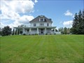
|  McElwain House - Caribou ME McElwain House - Caribou ME
in U.S. National Register of Historic Places The McElwain House is located at the intersection of Presque Isle Road and Main Street in Caribou ME. It was listed in 1982.
N46 49.910 W68 00.616 posted by: nomadwillie location: Maine date approved: 07/26/2009 last visited: 07/20/2009 |
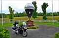 view gallery view gallerySW26.7 km |  First Successful Transatlantic Balloon Flight - Presque Isle ME First Successful Transatlantic Balloon Flight - Presque Isle ME
in First of its Kind Double Eagle II, piloted by Ben Abruzzo, Maxie Anderson, and Larry Newman, became the first balloon to cross the Atlantic Ocean when it landed 17 August 1978 in Miserey near Paris, 137 hours 6 minutes after leaving Presque Isle, Maine. posted by: nomadwillie location: Maine date approved: 06/27/2013 last visited: never |
 NW26.9 km |  Caribou Public Library Caribou Public Library
in Wi-Fi Hotspots Located at the Caribou Public Library, 30 High Street, in Caribou, Maine. posted by: blevesque location: Maine date approved: 11/19/2005 last visited: 05/26/2009 |
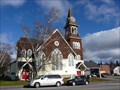 view gallery view galleryNW27.2 km | Gray Memorial United Methodist Church and Parsonage - Caribou ME in U.S. National Register of Historic Places Grey Memorial is located at 8 Prospect St and was built in 1912 posted by: nomadwillie location: Maine date approved: 07/04/2011 last visited: 10/30/2010 |
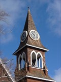 view gallery view galleryNW27.2 km |  Grey Memorial Church Clock - Caribou ME Grey Memorial Church Clock - Caribou ME
in Town Clocks Located at 8 Prospect St in Caribou, ME posted by: nomadwillie location: Maine date approved: 07/04/2011 last visited: 10/30/2010 |
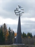 view gallery view galleryNW28.5 km |  Unique Windmill - Caribou ME Unique Windmill - Caribou ME
in Windmills Located on Washburn St between Mitchell Rd and York St posted by: nomadwillie location: Maine date approved: 07/04/2011 last visited: 10/29/2010 |
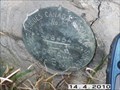
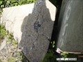 view gallery view galleryN31.4 km | BENCHMARK # 71B210 in Canadian Benchmarks Bridge (Portage rd) over rapide des femmes creek. Accessible by passenger car or light truck and a walk of less than 50 m. Benchmark possibly missing ? posted by: Firefighter001 location: New Brunswick, Canada date approved: 07/21/2008 last visited: 07/18/2008 |
 view gallery view galleryN31.9 km | BENCHMARK # 71B209 in Canadian Benchmarks "Rapide des femmes bridge" benchmark is accessible by passenger car or light truck and a walk of less than 50 m. Found on Rue ouellette, turn right at the end of Portage road. Used to be on old trans Canada highway route 2. posted by: Firefighter001 location: New Brunswick, Canada date approved: 07/17/2008 last visited: 07/19/2008 |
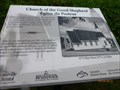 view gallery view gallery S32.3 km S32.3 km
|  The church of the good shepherd-New Brunswick-Canada The church of the good shepherd-New Brunswick-Canada
in Signs of History L'Église du Pasteur! the church of Good Shepherd! posted by: gemeloj location: New Brunswick, Canada date approved: 08/27/2013 last visited: 08/28/2013 |
 view gallery view galleryS32.8 km |  Potato World - Florenceville-Bristol, NB Potato World - Florenceville-Bristol, NB
in Oddball Museums Come and discover the impact the humble potato has had on the survival of New Brunswick’s early settlers and how important it is to the economy of the Province today. posted by: model12 location: New Brunswick, Canada date approved: 09/10/2011 last visited: 09/24/2022 |
 view gallery view galleryS33.3 km | Florenceville Bridge - Florenceville-Bristol, New Brunswick, Canada in Covered Bridges Florenceville Bridge posted by: marchanddeboeufs location: New Brunswick, Canada date approved: 04/16/2014 last visited: 06/01/2012 |
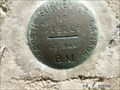
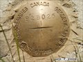 view gallery view galleryN33.3 km | BENCHMARK #92B025 in Canadian Benchmarks Can be found off of portage road in Grand Falls on the cemetary grounds. Found on the front side of the brick storage hut facing the road, just to the right of the door near the bottom at ground level. Co-ordinates are in (WSG 84) Map Datum. posted by: Firefighter001 location: New Brunswick, Canada date approved: 05/05/2010 last visited: never |
 view gallery view galleryN33.8 km | BENCHMARK # 78B454 in Canadian Benchmarks IN DRUMMOND
BRICK SCHOOL ON SOUTHWEST SIDE OF HIGHWAY #108, DIRECTLY OPPOSITE CHURCH, TABLET IN NORTHEAST CONCRETE FOUNDATION (BELOW 1949 STONE), 28 CM SOUTHEAST OF NORTH CORNER AND 13 CM BELOW WATER-TABLE. posted by: Firefighter001 location: New Brunswick, Canada date approved: 05/02/2010 last visited: never |
|