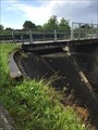
 view gallery view gallery NE0.2 km NE0.2 km
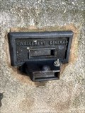
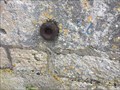
|   Repère de nivellement - Maison de Gare - Le Pechereau - Centre Val de Loire - France Repère de nivellement - Maison de Gare - Le Pechereau - Centre Val de Loire - France
in French Benchmarks Repère de nivellement sur l'ancienne gare du Pechereau. posted by:  lynx36 lynx36 location: Centre-Val-de-Loire, France date approved: 06/09/2022 last visited: 06/09/2022 |
 view gallery view gallery W2.3 km W2.3 km
| Repère de nivellement - Mur du canal - Argenton, France in French Benchmarks Repère de nivellement sur le mur du canal, proche du moulin d'Argenton sur Creuse. posted by: lynx36 location: Centre-Val-de-Loire, France date approved: 11/17/2018 last visited: 11/17/2018 |
 view gallery view gallery NW2.4 km NW2.4 km
| Repère de nivellement - Pont Vieux - Argenton sur Creuse in French Benchmarks Repère de nivellement sur le Pont Vieux, parapet amont , face à la route posted by: lynx36 location: Nouvelle-Aquitaine, France date approved: 11/22/2018 last visited: 08/26/2018 |
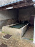 view gallery view galleryW2.7 km | ") Lavoir de Chateauneuf - Argenton sur Creuse - Indre - Centre Val de Loire - FRA Lavoir de Chateauneuf - Argenton sur Creuse - Indre - Centre Val de Loire - FRA
in Lavoir (wash houses) Le lavoir de Chateauneuf est un captage de la Font Furat posted by: lynx36 location: Centre-Val-de-Loire, France date approved: 01/06/2023 last visited: 01/06/2023 |
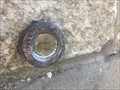
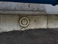
 view gallery view galleryW2.7 km | Repère de nivellement de l'Eglise St marcel in French Benchmarks Repère de nivellement de l'Eglise - Angle Ouest du mur Nord posted by: lynx36 location: Centre-Val-de-Loire, France date approved: 11/22/2018 last visited: 08/26/2018 |
 view gallery view galleryNW2.7 km | Repère de nivellement - Gare d'Argenton sur Creuse - Centre Val de Loire - FRA in French Benchmarks Repère de nivellement sur le quai de la gare d'Argenton
Cachée sous un banc ! posted by: lynx36 location: Centre-Val-de-Loire, France date approved: 09/04/2022 last visited: 09/04/2022 |
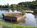
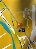 view gallery view galleryNW2.9 km |  Vous êtes ici - Argenton sur Creuse et Voie Verte - Indre - Centre Val de Loire - FRA Vous êtes ici - Argenton sur Creuse et Voie Verte - Indre - Centre Val de Loire - FRA
in 'You Are Here' Maps Panneau d'information sur Argenton sur Creuse et aussi la Voie Verte (voie vélo) posted by: lynx36 location: Centre-Val-de-Loire, France date approved: 09/04/2022 last visited: 09/04/2022 |
 view gallery view gallery S2.9 km S2.9 km
| Repère de Nivellement Chapelle de Villarnoux in French Benchmarks Soubassement du mur pignon Ouest posted by: lynx36 location: Centre-Val-de-Loire, France date approved: 07/09/2017 last visited: 07/09/2017 |
 view gallery view galleryS3.2 km | Repère de Nivellement - Chemin de fer in French Benchmarks Mur de soutènement attenant au Nord-Est du pont. posted by: lynx36 location: Centre-Val-de-Loire, France date approved: 07/09/2017 last visited: 07/09/2017 |
 view gallery view galleryNW3.4 km | Repère de Nivellement Moulin St Etienne in French Benchmarks Mur pignon sud du moulin St Etienne posted by: lynx36 location: Centre-Val-de-Loire, France date approved: 09/16/2017 last visited: 09/15/2017 |
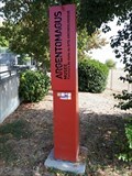
 view gallery view galleryNW3.4 km |  Le pont romain - Argenton-sur-Creuse (Indre), France Le pont romain - Argenton-sur-Creuse (Indre), France
in Ancient Roman Civilization [FR] Ce pont représente un ouvrage d'art de l'ancienne voie romaine entre Argentomagus et Lemovices (Limoges). [EN] The remains were formerly a bridge which linked Argentomagus and Lemovices (Limoges) during the Roman period. posted by: RakeInTheCache location: Centre-Val-de-Loire, France date approved: 10/10/2020 last visited: 11/13/2022 |
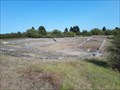
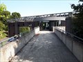 view gallery view galleryNW3.5 km | Le Musée et site archéologiques d'Argentomagus - Saint-Marcel (Indre) - France in Ancient Roman Civilization [FR] Le musée archéologique de Saint-Marcel fut ouvert en 1990 et expose les objets mis au jour sur le site. [EN] The archological museum was opened in 1990 and exhibits objects found at the site. posted by: RakeInTheCache location: Centre-Val-de-Loire, France date approved: 10/05/2020 last visited: 06/21/2022 |
 view gallery view galleryNW3.5 km |  Le Musée et site archéologiques d'Argentomagus - Saint-Marcel (Indre) - France Le Musée et site archéologiques d'Argentomagus - Saint-Marcel (Indre) - France
in History Museums [FR] Le musée archéologique de Saint-Marcel fut ouvert en 1990 et expose les objets mis au jour sur le site. [EN] The archological museum was opened in 1990 and exhibits objects found at the site. posted by: RakeInTheCache location: Centre-Val-de-Loire, France date approved: 10/07/2020 last visited: 06/21/2022 |
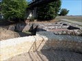 view gallery view galleryNW3.5 km |  Aqueduc Romain et Bassins Collecteurs - Saint-Marcel (Indre) - France Aqueduc Romain et Bassins Collecteurs - Saint-Marcel (Indre) - France
in Ancient Aqueducts [FR] Un mur aqueduc à contreforts et arcs de décharge amenant très probablement l’eau captée en amont. [EN] A buttressed aqueduct wall very probably carried water diverted upstream. posted by: RakeInTheCache location: Centre-Val-de-Loire, France date approved: 10/05/2020 last visited: 06/21/2022 |
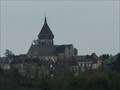
 view gallery view galleryNW3.7 km |  Église Saint-Marcel - Saint-Marcel (Indre), France Église Saint-Marcel - Saint-Marcel (Indre), France
in Romanesque Architecture [FR] L'église actuelle est construite sur une crypte romano-byzantine du viiie siècle. [EN] Today's church is constructed over a Romano-byzantine crypt from the 8th century. posted by: RakeInTheCache location: Centre-Val-de-Loire, France date approved: 10/10/2020 last visited: never |
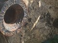
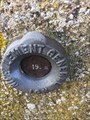
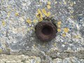 view gallery view galleryNW3.7 km | Repère de Nivellement Eglise St Marcel in French Benchmarks Repère de nivellement sur l'église St Marcel classée Monument Historique posted by: lynx36 location: Centre-Val-de-Loire, France date approved: 03/01/2016 last visited: 02/28/2016 |
 view gallery view galleryNW3.7 km | Relevé géodésique de l'Eglise St Marcel in French Benchmarks Point Géodésique
Point B Clocher Base Croix
Point C Centre Croix
Point A Borne ?? posted by: lynx36 location: Centre-Val-de-Loire, France date approved: 03/01/2016 last visited: 02/28/2016 |
 view gallery view galleryNW3.9 km | Théâtre romain d'Argentomagus - Saint Marcel (Indre), France in Ancient Roman Civilization [FR] Argentomagus est un oppidum du peuple gaulois des Bituriges qui a été occupé par les Romains. [EN] The city of Argentomagus reached its peak during the Gallo-Roman period in the 2nd and 3rd century CE. posted by: RakeInTheCache location: Centre-Val-de-Loire, France date approved: 10/09/2020 last visited: 06/21/2022 |
 view gallery view gallery N6.4 km N6.4 km
|  Pont couvert du Pont-Chretien-Chabenet, France Pont couvert du Pont-Chretien-Chabenet, France
in Wikipedia Entries [FR] Pont couvert en bois, franchissant la Bouzanne, y compris les ouvrages en maçonnerie du chemin d'accès à l'Ouest [EN] Wooden covered bridge over the Bouzanne River, including the masonry structures of the access road to the west posted by: Blanko36 location: Centre-Val-de-Loire, France date approved: 10/09/2022 last visited: 10/09/2022 |
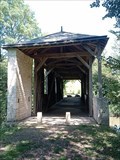 view gallery view galleryN6.4 km |  Pont couvert du Pont-Chretien-Chabenet, France Pont couvert du Pont-Chretien-Chabenet, France
in Monuments Historiques Français [FR] Pont couvert en bois, franchissant la Bouzanne, y compris les ouvrages en maçonnerie du chemin d'accès à l'Ouest. [EN] Wooden covered bridge over the Bouzanne River, including the masonry structures of the access road to the west. posted by: Blanko36 location: Centre-Val-de-Loire, France date approved: 10/09/2022 last visited: 10/09/2022 |
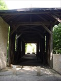 view gallery view galleryN6.4 km |  Pont couvert de Pont-Chretien-Chabanet. France Pont couvert de Pont-Chretien-Chabanet. France
in Covered Bridges Pont couvert de Pont-Chretien-Chabanet posted by: lulu_et_compagnie location: Centre-Val-de-Loire, France date approved: 09/02/2015 last visited: 10/08/2022 |
 view gallery view gallery SW7.1 km SW7.1 km
| Repère de nivellement - Eglise St Germain - Celon - Indre - Centre Val de Loire in French Benchmarks Repère de nivellement sur l’église St Germain de Celon posted by: lynx36 location: Centre-Val-de-Loire, France date approved: 01/24/2021 last visited: 01/23/2021 |
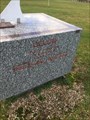 view gallery view gallerySW7.1 km |  N 46° 31' 15 E 1° 30'5 - Celon - Indre - Centre Val de Loire N 46° 31' 15 E 1° 30'5 - Celon - Indre - Centre Val de Loire
in Permanent Geographic Coordinates Plaque CELON avec les coordonnées et Cadran solaire posted by: lynx36 location: Centre-Val-de-Loire, France date approved: 02/06/2021 last visited: 01/23/2021 |
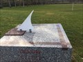 view gallery view gallerySW7.4 km |  Cadran Solaire - Celon - Indre - Centre Val de Loire Cadran Solaire - Celon - Indre - Centre Val de Loire
in Sundials Cadran solaire posé sur un bloc de granit près du stade municipal posted by: lynx36 location: Centre-Val-de-Loire, France date approved: 01/24/2021 last visited: 01/23/2021 |
 view gallery view galleryN7.6 km | Repère de nivellement - Eglise Saint Etienne, Tendu, France in French Benchmarks [FR] Repère de nivellement à gauche de la porte [EN] Leveling mark on the left side of the door posted by: Blanko36 location: Centre-Val-de-Loire, France date approved: 08/19/2022 last visited: 08/22/2022 |
|