 view gallery view gallery SW11.3 km SW11.3 km
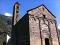
|   Church of San Nicola - Giornico, TI, Switzerland Church of San Nicola - Giornico, TI, Switzerland
in Austrian and Swiss National Heritage Sites This church from the 12th century is the most impressive example of Lombard Romanesque architecture in Switzerland. posted by:  fi67 fi67 location: Ticino, Switzerland date approved: 09/26/2013 last visited: never |
 view gallery view gallerySW11.3 km |  Church of San Nicola - Giornico, TI, Switzerland Church of San Nicola - Giornico, TI, Switzerland
in Romanesque Architecture This church from the 12th century is the most impressive example of Lombard Romanesque architecture in Switzerland. posted by: fi67 location: Ticino, Switzerland date approved: 07/17/2018 last visited: never |
 view gallery view gallerySW11.3 km |  Church of San Nicola - Giornico, TI, Switzerland Church of San Nicola - Giornico, TI, Switzerland
in Medieval Churches This church from the 12th century is the most impressive example of Lombard Romanesque architecture in Switzerland. posted by: fi67 location: Ticino, Switzerland date approved: 09/26/2013 last visited: never |
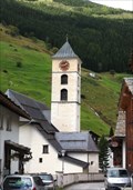
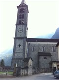 view gallery view gallerySW11.3 km |  Chiesa Parrocchiale di San Michele - Giornico, TI, Switzerland Chiesa Parrocchiale di San Michele - Giornico, TI, Switzerland
in This Old Church The parish church of Giornico. posted by: fi67 location: Ticino, Switzerland date approved: 09/27/2013 last visited: never |
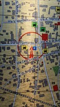 view gallery view gallery S14.2 km S14.2 km
|  You are here circle&arrow - Biasca, Ticino, Switzerland You are here circle&arrow - Biasca, Ticino, Switzerland
in 'You Are Here' Maps In the small town center of Biasca you will find a parkinglot and the map of the city on it. posted by:  T-Team! T-Team! location: Ticino, Switzerland date approved: 09/01/2022 last visited: never |
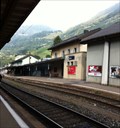
 view gallery view galleryS15 km | Bahnhof - Biasca, TI, Switzerland in Austrian and Swiss National Heritage Sites The railway station of Biasca. posted by: fi67 location: Ticino, Switzerland date approved: 09/26/2013 last visited: 10/16/2016 |
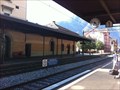 view gallery view galleryS15 km |  Biasca, TI, Switzerland Biasca, TI, Switzerland
in Train Stations/Depots The railway station of Biasca. posted by: fi67 location: Ticino, Switzerland date approved: 09/26/2013 last visited: 10/16/2016 |
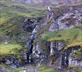
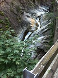 view gallery view gallery W15.4 km W15.4 km
|  Gola del Piottino Waterfalls - Rodi-Fiesso, TI, Switzerland Gola del Piottino Waterfalls - Rodi-Fiesso, TI, Switzerland
in Waterfalls One of the waterfalls in Piottino Gorge. posted by: fi67 location: Ticino, Switzerland date approved: 09/25/2013 last visited: never |
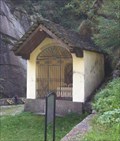 view gallery view galleryW15.4 km | Waychapel in the Piottino Gorge - Rodi-Fiesso, TI, Switzerland in Waychapels A waychapel in the Piottino Gorge north of Rodi-Fiesso. posted by: fi67 location: Ticino, Switzerland date approved: 09/25/2013 last visited: never |
 view gallery view gallery E16.7 km E16.7 km
|  Passo San Bernardino, Graubünden, CH Passo San Bernardino, Graubünden, CH
in Named Mountain Gaps San Bernardino Pass (elevation 2,066 metres or 6,778 feet) is a high mountain pass in the Swiss Alps connecting the Hinterrhein and the Mesolcina (Misox) valleys between Thusis (Graubünden) and Bellinzona (Ticino). posted by: André de Montbard location: Graubünden, Switzerland date approved: 04/06/2015 last visited: 06/12/2023 |
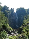 view gallery view gallerySW20.8 km | Ticino Waterfall in Waterfalls Geocache GCK3AY posted by: Schmusebär location: Ticino, Switzerland date approved: 02/12/2006 last visited: 10/17/2016 |
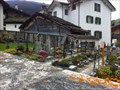 view gallery view gallery NE22.7 km NE22.7 km
|  Friedhof - Vals, GR, Switzerland Friedhof - Vals, GR, Switzerland
in Worldwide Cemeteries The cemetery of Vals. posted by: fi67 location: Graubünden, Switzerland date approved: 12/16/2014 last visited: never |
 view gallery view galleryNE22.7 km | St. Peter und Paul - Vals, GR, Switzerland in Austrian and Swiss National Heritage Sites The Roman Catholic parish church of Vals dates from the 15th century. posted by: fi67 location: Graubünden, Switzerland date approved: 12/15/2014 last visited: never |
 view gallery view galleryNE22.7 km | St. Peter und Paul - Vals, GR, Switzerland in Roman Catholic Churches The Roman Catholic parish church of Vals dates from the 15th century. posted by: fi67 location: Graubünden, Switzerland date approved: 12/15/2014 last visited: never |
 view gallery view galleryNE24.5 km | Tomülbach Waterfall - Vals, GR, Switzerland in Waterfalls A great waterfall at the hiking trail between Tomülpass and Vals. posted by: fi67 location: Graubünden, Switzerland date approved: 12/11/2014 last visited: never |
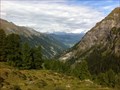 view gallery view galleryNE26.1 km |  Tomülpass - Safien, GR, Switzerland Tomülpass - Safien, GR, Switzerland
in Scenic Hikes The hiking trail over Tomülpass connects the valleys of Safien and Vals and takes about five to six hours. posted by: fi67 location: Graubünden, Switzerland date approved: 12/14/2014 last visited: never |
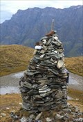 view gallery view galleryNE26.2 km |  Cairn at Tomülpass - Safien, GR, Switzerland Cairn at Tomülpass - Safien, GR, Switzerland
in Cairns This summit cairn is located at the summit of Tomülpass. posted by: fi67 location: Graubünden, Switzerland date approved: 12/13/2014 last visited: never |
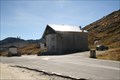
 view gallery view galleryW26.7 km | Airolo, TI, Switzerland in Train Stations/Depots Airolo is located directly at the southern end of Gotthard Tunnel. posted by: fi67 location: Ticino, Switzerland date approved: 09/25/2013 last visited: never |
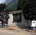 view gallery view galleryW26.9 km | Traforo del Gottardo - Airolo, TI, Switzerland in Austrian and Swiss National Heritage Sites A monument at the railway station of Airolo, dedicated to the workers killed during the construction of the Gotthard Tunnel. posted by: fi67 location: Ticino, Switzerland date approved: 09/24/2013 last visited: never |
 view gallery view galleryW26.9 km |  Traforo del Gottardo - Airolo, TI, Switzerland Traforo del Gottardo - Airolo, TI, Switzerland
in Occupational Monuments A monument at the railway station of Airolo, dedicated to the workers killed during the construction of the Gotthard Tunnel. posted by: fi67 location: Ticino, Switzerland date approved: 09/24/2013 last visited: never |
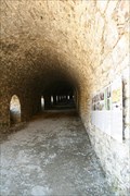
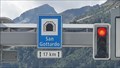 view gallery view galleryW27.4 km |  LONGEST - Road tunnel in Switzerland - Göschenen, Uri, Switzerland LONGEST - Road tunnel in Switzerland - Göschenen, Uri, Switzerland
in Superlatives The Gotthart Road tunnel was (went it was built in 1980) the longest road tunnel in the world. Now it can still claim to be the longest... but in Switzerland. posted by: T-Team! location: Uri, Switzerland date approved: 09/01/2022 last visited: never |
 view gallery view galleryE28.6 km |  Splügengalerie - Graubünden, CH Splügengalerie - Graubünden, CH
in Official Local Tourism Attractions Die Splügengalerie auf dem Splügenpass. posted by: Tharandter location: Graubünden, Switzerland date approved: 10/07/2013 last visited: never |
 view gallery view galleryE29 km |  Splügenpass - Graubünden (CH) / Lombardia (I) Splügenpass - Graubünden (CH) / Lombardia (I)
in Border Crossings Der Grenzübergang Splügenpass. The Spluegen border crossing between Switzerland and Italy. posted by: Tharandter location: Graubünden, Switzerland date approved: 10/08/2013 last visited: 10/03/2018 |
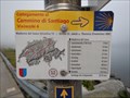 view gallery view galleryW30.6 km |  Way Marker San Gottardo, TI, Switzerland Way Marker San Gottardo, TI, Switzerland
in Way of St. James Way Marker pass San Gottardo posted by: DerEinsameSucher location: Ticino, Switzerland date approved: 10/21/2016 last visited: never |
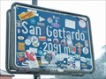 view gallery view galleryW30.9 km |  Gotthard Pass, Switzerland (2091) Gotthard Pass, Switzerland (2091)
in Elevation Signs Gotthard Pass (Italian: Passo del San Gottardo) (el. 2106 m.) a high mountain pass in Switzerland. posted by: tijgetje location: Ticino, Switzerland date approved: 08/31/2009 last visited: 12/05/2015 |
|