 view gallery view gallery NW3.7 km NW3.7 km
|   Oeschinen See - Kandersteg, Switzerland Oeschinen See - Kandersteg, Switzerland
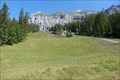
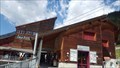
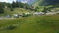
in Winter Sports Locations The ski area above Kandersteg. Easy and stress-free access from Thun, Bern, or Solothurn posted by:  tofixe tofixe location: Bern, Switzerland date approved: 08/24/2018 last visited: never |
 view gallery view gallery N3.9 km N3.9 km
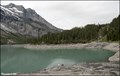
|  Oeschinensee / Lake Oeschinen - Bernese Oberland (Switzerland) Oeschinensee / Lake Oeschinen - Bernese Oberland (Switzerland)
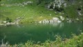
in Natural Lakes Oeschinensee (Lake Oeschinen), is a beautiful Alpine lake, fed by the glacial brooks of the 3000 meters high peaks of Blüemlisalp, Oeschinenhorn, Fründenhorn and Doldenhorn. Lake is located 4 km east of Kandersteg in the Oeschinen valley... posted by: Dorcadion Team location: Bern, Switzerland date approved: 03/27/2012 last visited: 06/01/2016 |
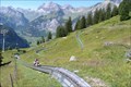 view gallery view galleryNW4.8 km |  Alpine Slide Oeschinensee - Kandersteg, Bern, Switzerland Alpine Slide Oeschinensee - Kandersteg, Bern, Switzerland
in Bobsleigh Chutes and Mountain Slides In the slopes of Kandersteg you'll find this moutain slide. posted by: tofixe location: Bern, Switzerland date approved: 07/31/2018 last visited: never |
 view gallery view gallery W5.5 km W5.5 km
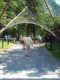
|  International scouting Camp, Kandersteg, Switzerland International scouting Camp, Kandersteg, Switzerland
in Campgrounds Permanent international scouting camp in Switzerland posted by: tijgetje location: Bern, Switzerland date approved: 08/31/2009 last visited: 06/01/2016 |
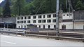
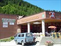
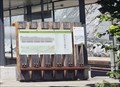
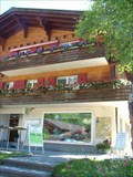 view gallery view galleryNW5.6 km |  Tourist Information Kandersteg, Switzerland Tourist Information Kandersteg, Switzerland
in Tourist Information Centers - Visitor Centers Information Office in the city Kandersteg posted by: tijgetje location: Bern, Switzerland date approved: 08/31/2009 last visited: 06/11/2013 |
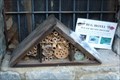 view gallery view galleryW5.6 km |  Insect hotel in Kandersteg - Switzerland Insect hotel in Kandersteg - Switzerland
in Insect Hotels In Kandersteg you'll find a nice insect hotel. posted by: tofixe location: Bern, Switzerland date approved: 09/05/2017 last visited: never |
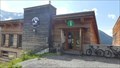
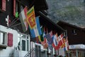 view gallery view galleryW5.6 km |  KISC - Kandersteg, BE, Switzerland KISC - Kandersteg, BE, Switzerland
in Flags of the World Outside KISC's Head Quarters you'll find severall flags form countries around the world. posted by: tofixe location: Bern, Switzerland date approved: 09/20/2017 last visited: never |
 view gallery view gallery SE6.9 km SE6.9 km
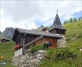
|  Antonius-Kapelle Weritzalp - Blatten im Lötschental, VS, Switzerland Antonius-Kapelle Weritzalp - Blatten im Lötschental, VS, Switzerland
in Waychapels The small chapel on Weritzalp was built in 1976. posted by: fi67 location: Valais, Switzerland date approved: 12/02/2019 last visited: never |
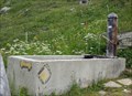 view gallery view gallerySE6.9 km |  Brunnen Weritzalp - Blatten im Lötschental, VS, Switzerland Brunnen Weritzalp - Blatten im Lötschental, VS, Switzerland
in Fountains A simple concrete fountain next to a hiking trail in the Alpine hamlet Weritzalp. posted by: fi67 location: Valais, Switzerland date approved: 12/01/2019 last visited: never |
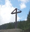
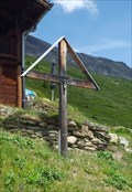 view gallery view gallerySE6.9 km |  Wooden Cross Weritzalp - Blatten im Lötschental, VS, Switzerland Wooden Cross Weritzalp - Blatten im Lötschental, VS, Switzerland
in Christian Crosses A wooden cross next to a hiking trail in the Alpine hamlet Weritzalp. posted by: fi67 location: Valais, Switzerland date approved: 12/02/2019 last visited: never |
 view gallery view gallerySE7.1 km | Tourist Information Lötschental - Lauchernalp - Wiler,VS, Switzerland in Tourist Information Centers - Visitor Centers An information center of the Lötschental tourist information, next to the top station of the aerial tramway to Lauchernalp. posted by: fi67 location: Valais, Switzerland date approved: 10/31/2019 last visited: never |
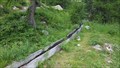 view gallery view gallerySE7.6 km |  Hori-Suon Tellialp - Blatten im Lötschental, VS, Switzerland Hori-Suon Tellialp - Blatten im Lötschental, VS, Switzerland
in Ancient Aqueducts A traditional irrigation canal near Tellistaffel at the northern slope of Lötschental. posted by: fi67 location: Valais, Switzerland date approved: 12/17/2019 last visited: never |
 view gallery view gallerySE8 km |  Luftseilbahn Wiler-Lauchernalp - Wiler,VS, Switzerland Luftseilbahn Wiler-Lauchernalp - Wiler,VS, Switzerland
in Aerial Lifts An aerial tramway in the Lötschental region. posted by: fi67 location: Valais, Switzerland date approved: 10/27/2019 last visited: never |
 view gallery view gallerySE8.7 km | Schwarzsee - Blatten im Lötschental, VS, Switzerland in Natural Lakes Schwarzsee on 1860 meters above sea level north of Blatten im Lötschental. posted by: fi67 location: Valais, Switzerland date approved: 12/07/2019 last visited: never |
 view gallery view gallery E9.8 km E9.8 km
| Wooden Cross - Fafleralp, VS, Switzerland in Christian Crosses A wooden cross on a boulder north of Fafleralp. posted by: fi67 location: Valais, Switzerland date approved: 12/15/2019 last visited: never |
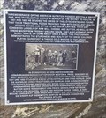 view gallery view galleryE9.8 km |  Weston A. Price - Fafleralp, VS, Switzerland Weston A. Price - Fafleralp, VS, Switzerland
in Citizen Memorials A plaque on Fafleralp to commemorate a visit of the American nutrition pioneer Weston A. Price in the early 1930s. posted by: fi67 location: Valais, Switzerland date approved: 12/08/2019 last visited: never |
 view gallery view galleryE10.5 km | Camping Gletscheralp - Fafleralp, VS, Switzerland in Campgrounds A small campground near Fafleralp. posted by: fi67 location: Valais, Switzerland date approved: 12/17/2019 last visited: never |
 view gallery view gallery S11.3 km S11.3 km
|  Goppenstein, VS, Switzerland Goppenstein, VS, Switzerland
in Train Stations/Depots The railway station at the southern end of the Lötschberg tunnel. posted by: fi67 location: Valais, Switzerland date approved: 12/22/2019 last visited: never |
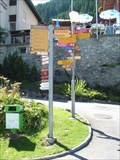
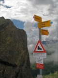 view gallery view galleryW12.4 km |  Sign Over Adelboden, Switzerland Sign Over Adelboden, Switzerland
in Direction and Distance Arrows Sign over the valley. posted by:  Dáin & Olík Dáin & Olík location: Bern, Switzerland date approved: 05/26/2009 last visited: 06/11/2013 |
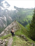 view gallery view galleryW12.9 km |  From Adelboden to Engstligenalp, Switzerland From Adelboden to Engstligenalp, Switzerland
in Scenic Hikes Beautiful trail from Adelboden up to Engstligenalp posted by: Dáin & Olík location: Bern, Switzerland date approved: 05/26/2009 last visited: never |
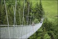 view gallery view galleryNW13.7 km |  Steel-rope Bridge - Switzerland Steel-rope Bridge - Switzerland
in Pedestrian Suspension Bridges Wonderful pedestrian suspension bridge over a valley. posted by: Dáin & Olík location: Bern, Switzerland date approved: 05/04/2009 last visited: 05/31/2008 |
 view gallery view gallery NE16.1 km NE16.1 km
| Tourist Information Mürren, Switzerland in Tourist Information Centers - Visitor Centers Information Office in the city Mürren posted by: tijgetje location: Bern, Switzerland date approved: 08/23/2008 last visited: never |
 view gallery view galleryNE16.3 km | Where do you want to go - Mürren, Switzerland in Direction and Distance Arrows At the corner of the "Hehmatten" and Low road "Im usseren Dorf" posted by: tijgetje location: Bern, Switzerland date approved: 08/21/2008 last visited: 08/25/2009 |
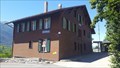 view gallery view galleryS16.4 km | Hohtenn, VS, Switzerland in Train Stations/Depots The railway station of Hohtenn, opened in 1913. posted by: fi67 location: Valais, Switzerland date approved: 08/01/2020 last visited: never |
 view gallery view galleryS16.4 km |  Lötschberger Südrampe - Hohtenn, VS, Switzerland Lötschberger Südrampe - Hohtenn, VS, Switzerland
in Rails to Trails Lötschberger Südrampe is a hiking trail along the railway tracks between Hohtenn and Brig. It was not only the first trail for railway enthusiasts when it opened in 1960, it also uses the roadbed of the former construction railway when possible. posted by: fi67 location: Valais, Switzerland date approved: 07/28/2020 last visited: never |
|