 view gallery view gallery W3.5 km W3.5 km
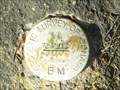
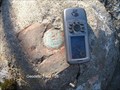
|   73U203 73U203
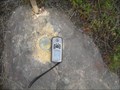
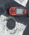
in Canadian Benchmarks A geodetic Benchmark East of old section of hwy 69 just south of Gladu Road near Geocache GC2DK5X in Greater Sudbury.
Measured coordinates N5141063 E508787 posted by:  broder broder location: Ontario, Canada date approved: 09/04/2010 last visited: 09/03/2010 |
 view gallery view gallery S5.1 km S5.1 km
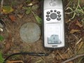
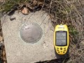
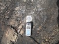
| 73U200 in Canadian Benchmarks A geodetic benchmark located on the west side of old section hwy 69 opposite the new access road to the new portion of hwy 69 and south of the Horseshoe Lake Rd. The measured coordinates are N= 5136336 E= 510868 posted by: broder location: Ontario, Canada date approved: 09/06/2010 last visited: never |
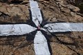
 view gallery view galleryS5.8 km | 73U199 in Canadian Benchmarks A geodetic benchmark located on the west side of old section of hwy 69 north of the Wanapitei River. My measured coordinates are N= 5135620 E= 512355 posted by: broder location: Ontario, Canada date approved: 09/08/2010 last visited: 08/23/2017 |
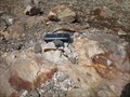
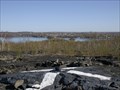
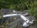
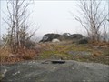
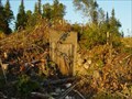 view gallery view galleryS6.3 km |  Bunker exposed due to clearing for Highway 69 Bunker exposed due to clearing for Highway 69
in Earth Homes This bunker was built in 1957. Previously hidden by trees and over growth. posted by:  wd57 wd57 location: Ontario, Canada date approved: 08/12/2006 last visited: 09/30/2007 |
 view gallery view gallery NW7.1 km NW7.1 km
| Sudbury 64-32 in Canadian Benchmarks A 1964 Horizontal control point that utilized a 1929 Topographical Disk. It is located just east and south of the SW bypass bridge over the CPR tracks near Romford. posted by: broder location: Ontario, Canada date approved: 11/26/2010 last visited: never |
 view gallery view galleryNW7.6 km | Sudbury 64-31 in Canadian Benchmarks A 1964 survey disk posted by: broder location: Ontario, Canada date approved: 04/12/2011 last visited: never |
 view gallery view gallery NE7.7 km NE7.7 km
|  Wahnapitae P.O. P0M 3C0 Wahnapitae P.O. P0M 3C0
in Canada Post Offices Wahnapitae Post office posted by: bushman003 location: Ontario, Canada date approved: 06/19/2010 last visited: 02/10/2011 |
 view gallery view galleryNE8 km | 027SPT-3 in Canadian Benchmarks One of a group of 10 located in the eastern part of the City Of Greater Sudbury, Ontario. Accessible from the north side of Highway 17 at the bottom of the hill in the village of Wahnapitae, and a round-trip hike of less than 3 kms. posted by: tec_64 location: Ontario, Canada date approved: 08/10/2012 last visited: never |
 view gallery view galleryNW8.2 km | Sudbury 64-35 in Canadian Benchmarks A Topographical survey monument. posted by: broder location: Ontario, Canada date approved: 03/16/2010 last visited: never |
 view gallery view gallery N8.2 km N8.2 km
| 027SPT-8 in Canadian Benchmarks One of a group of 10 located in the eastern part of the City Of Greater Sudbury, Ontario. Accessible from the north side of Highway 17 just east of RR90 Garson-Coniston Road and a round-trip hike of about 3 kms. posted by: tec_64 location: Ontario, Canada date approved: 09/12/2011 last visited: never |
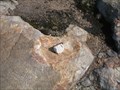
 view gallery view galleryS8.4 km | Geodetic Survey of Canada 73U195 in Canadian Benchmarks Disk along HWY 69 Southeast of Sudbury posted by: bushman003 location: Ontario, Canada date approved: 06/17/2010 last visited: 04/24/2010 |
 view gallery view galleryNW8.5 km | 730935 in Canadian Benchmarks A second order horizontal control point located on a prominent rock off the ENE end of South Bay Road in Sudbury. posted by: tec_64 location: Ontario, Canada date approved: 04/29/2010 last visited: 06/15/2010 |
 view gallery view galleryNW8.9 km | Sudbury - Fresh Paint in Canadian Benchmarks Accessible by car and a walk of less than 20m. Located right beside the south side of South Bay Road at house number 2319 in Sudbury, Ontario. posted by: tec_64 location: Ontario, Canada date approved: 05/29/2010 last visited: 06/15/2010 |
 view gallery view galleryN8.9 km | 027SPT-2 in Canadian Benchmarks One of a group of 10 located in the eastern part of the City Of Greater Sudbury, Ontario. Accessible from the north side of Highway 17 just west of RR90 Garson-Coniston Road and a round-trip hike of about 5 kms. posted by: tec_64 location: Ontario, Canada date approved: 09/17/2011 last visited: 09/18/2011 |
 view gallery view galleryW9 km | 73U214 BM Lake Laurentian Conservation Area in Canadian Benchmarks Nice spot over looking Lake Laurentian. Very close to another benchmark. posted by: jwinther location: Ontario, Canada date approved: 11/03/2010 last visited: 02/27/2023 |
 view gallery view galleryW9 km | 663402 - NASA in Canadian Benchmarks NASA-GSFC Field Facilities Branch marker listed in the CSRS database.
This is the base and mount for a satellite tracking camera from the mid-sixties. posted by: tec_64 location: Ontario, Canada date approved: 04/16/2006 last visited: 02/27/2023 |
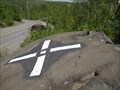
 view gallery view galleryW9.8 km | The old Ski Hill in Canadian Benchmarks A painted marker on top of the Old Ski Hill looking over Hwy 69. posted by: jwinther location: Ontario, Canada date approved: 05/18/2011 last visited: never |
 view gallery view galleryS10.1 km | Paddy 753006 in Canadian Benchmarks A 1975 first order marker located on a hill near an old Forestry Service tower footing. Drive south from Sudbury, Ontario on Hwy 69. Exit at Estaire Road and continue south on the old highway to Horseshoe Lake road. See further directions below. posted by: tec_64 location: Ontario, Canada date approved: 09/24/2010 last visited: never |
 view gallery view galleryNW10.3 km | Sudbury 64-36 Kingsway East in Canadian Benchmarks A Topographical Survey Monument located Southwest Side Kingsway Southeast of Third Ave posted by: broder location: Ontario, Canada date approved: 03/12/2010 last visited: never |
 view gallery view galleryNW10.9 km | Sudbury 64-26 in Canadian Benchmarks A Topographical Survey Monument Sudbury 64-26 South of Weller St
near the Branch 76 Legion posted by: broder location: Ontario, Canada date approved: 04/06/2010 last visited: 05/06/2013 |
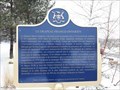 view gallery view galleryNW10.9 km |  LE DRAPEAU FRANCO-ONTARIEN LE DRAPEAU FRANCO-ONTARIEN
in Ontario Provincial Plaques A plaque describing the history and contribution of the Franco-Ontarian Flag very close to the spot it first flew in 1975. posted by: Loonwatcher location: Ontario, Canada date approved: 04/24/2018 last visited: never |
 view gallery view galleryNW11.7 km | Sudbury 64-19 Laurentian in Canadian Benchmarks A 1964 Topographical Survey Monument. In 1973 it was numbered 73U308 and in 1994 it was numbered 643119. posted by: broder location: Ontario, Canada date approved: 03/10/2010 last visited: 03/12/2010 |
 view gallery view galleryN11.7 km | Sudbury 64-49 in Canadian Benchmarks Topographical Survey Monument destroyed posted by: broder location: Ontario, Canada date approved: 03/28/2010 last visited: never |
 view gallery view galleryW11.7 km | 820105 in Canadian Benchmarks A bolt & washer on a hill top overlooking Mallard's Landing Subdivision. Easiest way from end Mallards Landing Drive walk South-West. There are 3 Reference Bolts & Washers in close proximity. posted by: broder location: Ontario, Canada date approved: 09/01/2010 last visited: never |
 view gallery view galleryNW11.9 km | Sudbury 64-47 in Canadian Benchmarks A 1964 topographical survey monument which has been destroyed is located west of the south end of Brookfield Ave in New Sudbury and 12 meters south and 4 meters west of Waymark 02719790043. posted by: broder location: Ontario, Canada date approved: 11/15/2010 last visited: never |
|