 view gallery view gallery NE1 km NE1 km
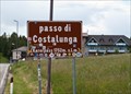
|   Passo di Costalunga (1752m) Passo di Costalunga (1752m)
in Elevation Signs Elevation sign on top of the mountain pass. posted by:  KateBum KateBum location: Trentino–Alto Adige, Italy date approved: 07/15/2009 last visited: 06/23/2013 |
 view gallery view galleryNE2.1 km | Rifugio Paolina (2125m) in Elevation Signs Mountain hut in the Rosengarten group. posted by: KateBum location: Trentino–Alto Adige, Italy date approved: 07/15/2009 last visited: 07/24/2018 |
 view gallery view galleryNE3.2 km | Rifugio Roda di Vael (2283m) in Elevation Signs Mountain hut in the Rosengarten group. posted by: KateBum location: Trentino–Alto Adige, Italy date approved: 07/15/2009 last visited: 08/01/2015 |
 view gallery view gallery SW4.8 km SW4.8 km
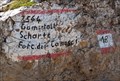
| Forcella del Camosci, Latemar (2564m) Gamsstallscharte in Elevation Signs Mountain gorge in the Latemar Group. posted by: KateBum location: Trentino–Alto Adige, Italy date approved: 07/19/2009 last visited: 07/17/2018 |
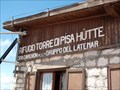 view gallery view gallerySW5.3 km | Rifugio Torre di Pisa (2671m) in Elevation Signs Mountain hut in the Latemar group. posted by: KateBum location: Trentino–Alto Adige, Italy date approved: 07/17/2009 last visited: 07/16/2018 |
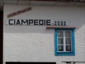 view gallery view galleryNE6.3 km | Rifugio Ciampedie SAT (2000m) in Elevation Signs Mountain hut in the Rosengarten group. posted by: KateBum location: Trentino–Alto Adige, Italy date approved: 07/17/2009 last visited: never |
 view gallery view gallery N6.3 km N6.3 km
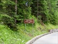
| Passo Nigra (1690m) in Elevation Signs Mountain pass at Rosengarten group. posted by: KateBum location: Trentino–Alto Adige, Italy date approved: 07/17/2009 last visited: never |
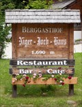 view gallery view galleryN6.3 km | Niger Joch Haus (1690m) in Elevation Signs Mountain hut near Passo Nigra at Rosengarten group.
posted by: KateBum location: Trentino–Alto Adige, Italy date approved: 07/17/2009 last visited: never |
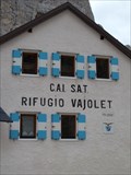 view gallery view galleryN6.9 km | Rifugio Vajolet SAT (2243m) in Elevation Signs Mountain hut in the Rosengarten group.
posted by: KateBum location: Trentino–Alto Adige, Italy date approved: 07/17/2009 last visited: 07/16/2019 |
 view gallery view galleryN8.7 km | Rifugio Passo Principe (2600m) in Elevation Signs Mountain hut in the Rosengarten group. posted by: KateBum location: Trentino–Alto Adige, Italy date approved: 07/17/2009 last visited: never |
 view gallery view galleryN8.7 km | Passo Principe (2601m) in Elevation Signs Mountain gorge in the Rosengarten group.
posted by: KateBum location: Trentino–Alto Adige, Italy date approved: 07/17/2009 last visited: never |
 view gallery view galleryN12.1 km | Rifugio Bolzano (2457m) in Elevation Signs Mountain hut at Schlern, Dolomies. posted by: KateBum location: Trentino–Alto Adige, Italy date approved: 07/17/2009 last visited: 03/12/2011 |
 view gallery view galleryN12.7 km | Saltner Hütte (1850m) in Elevation Signs Mountain hut at Alpe di Siusi. posted by: KateBum location: Trentino–Alto Adige, Italy date approved: 07/17/2009 last visited: 08/21/2009 |
 view gallery view gallery W14.5 km W14.5 km
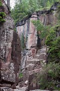
|  Die Dolomiten - Bletterbach Schlucht Die Dolomiten - Bletterbach Schlucht
in World Heritage Sites Die geologisch interessante Bletterbach-Schlucht ist seit 2009 'World Heritage Site' der UNESCO. /
The Bletterbach canyon and its interesting geological features have become a UNESCO World Heritage Site in 2009. posted by: netdust location: Trentino–Alto Adige, Italy date approved: 07/11/2011 last visited: 07/19/2017 |
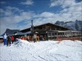 view gallery view galleryNE17.1 km |  Il Rifugio Club Moritzino (Piz La Ila), Italy Il Rifugio Club Moritzino (Piz La Ila), Italy
in Ski Lodges Club Moritzino on Piz La Ila Mountain is, besides your casual break from skiing, a gathering point for society and a must for all who love entertainment. The club’s fish evenings, DJ music, and evening skiing sessions are also legendary. posted by: btrodrigues location: Trentino–Alto Adige, Italy date approved: 10/23/2011 last visited: never |
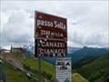 view gallery view galleryNE17.5 km | Passo Sella (2240m) in Elevation Signs Elevation sign on top of the mountain pass. posted by: KateBum location: Trentino–Alto Adige, Italy date approved: 07/15/2009 last visited: 08/24/2020 |
 view gallery view gallery NW18.5 km NW18.5 km
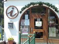
|  Tourist Information Center - Colllalbo, Italy Tourist Information Center - Colllalbo, Italy
in Tourist Information Centers - Visitor Centers Official tourist center for the Collalbo region posted by: tijgetje location: Trentino–Alto Adige, Italy date approved: 06/14/2010 last visited: never |
 view gallery view galleryN18.8 km | Tourist Information Center - Castelrotto, Italy in Tourist Information Centers - Visitor Centers Official tourist center for the Castelrotto region posted by: tijgetje location: Trentino–Alto Adige, Italy date approved: 06/14/2010 last visited: 07/03/2006 |
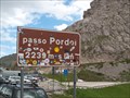 view gallery view galleryNE18.8 km | Passo Pordoi (2239m) in Elevation Signs Elevation sign on top of the mountain pass. posted by: KateBum location: Trentino–Alto Adige, Italy date approved: 07/16/2009 last visited: 09/06/2010 |
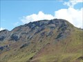 view gallery view galleryNE19.2 km |  Col del Cuc 2558m Col del Cuc 2558m
in Mountain Summits Col del Cuc 2558m posted by: DasUmmi location: Veneto, Italy date approved: 10/11/2011 last visited: never |
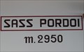 view gallery view galleryNE19.5 km | Sass Pordoi (2950m) in Elevation Signs Within the aerial ropeway station on the Sass Pordoi. posted by: KateBum location: Trentino–Alto Adige, Italy date approved: 07/16/2009 last visited: 09/06/2010 |
 view gallery view galleryNW19.8 km |  Erdpyramiden Renon, Italy Erdpyramiden Renon, Italy
in Places of Geologic Significance Erdpyramiden Renon, Italy posted by: luzzi-reloaded location: Trentino–Alto Adige, Italy date approved: 10/19/2011 last visited: 07/03/2006 |
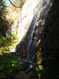 view gallery view galleryNE19.8 km |  Pilon Waterfall - Santa Catharina, Trentino, Italy Pilon Waterfall - Santa Catharina, Trentino, Italy
in Waterfalls Pilon Waterfall - Santa Catharina, Trentino, Italy posted by: luzzi-reloaded location: Trentino–Alto Adige, Italy date approved: 10/06/2012 last visited: 10/01/2015 |
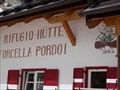 view gallery view galleryNE19.8 km | Rifugio Forcella Pordoi (2848m) in Elevation Signs Mountain hut at the way to Piz Boe. posted by: KateBum location: Trentino–Alto Adige, Italy date approved: 07/15/2009 last visited: 07/28/2015 |
 view gallery view galleryNE19.8 km | Tourist Information Center - Sankt Christina, Italy in Tourist Information Centers - Visitor Centers Official tourist center for Sankt Christina in Groden posted by: tijgetje location: Trentino–Alto Adige, Italy date approved: 06/14/2010 last visited: 01/05/2020 |
|