 view gallery view gallery SE0.2 km SE0.2 km
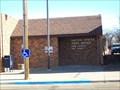
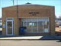
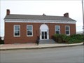
|   New Leipzig, North Dakota 58562 New Leipzig, North Dakota 58562
in U.S. Post Offices Small town post office. posted by:  NGComets NGComets location: North Dakota date approved: 11/01/2012 last visited: never |
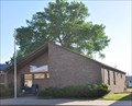
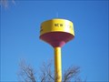 view gallery view gallerySE0.3 km |  Watertower - New Leipzig, North Dakota Watertower - New Leipzig, North Dakota
in Water Towers Modern style watertower in a small town on the prairie. posted by: NGComets location: North Dakota date approved: 11/03/2012 last visited: never |
 view gallery view gallery SW1.1 km SW1.1 km
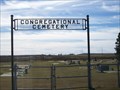
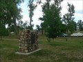
|  Congregational Cemetery, New Leipzig, North Dakota Congregational Cemetery, New Leipzig, North Dakota
in Worldwide Cemeteries Just west of town, with about 250 graves. posted by: NGComets location: North Dakota date approved: 11/26/2012 last visited: never |
 view gallery view gallery W28.6 km W28.6 km
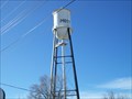
| Watertower, Mott, North Dakota in Water Towers Classic style watertower in a small town. posted by: NGComets location: North Dakota date approved: 11/01/2012 last visited: never |
 view gallery view galleryW29 km | Mott, North Dakota 58646 in U.S. Post Offices Small town post office. posted by: NGComets location: North Dakota date approved: 11/01/2012 last visited: never |
 view gallery view gallery E29.9 km E29.9 km
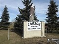
|  Carson ND - Pop. 286 Carson ND - Pop. 286
in Population Signs This Population Sign is on Highway 21 at Main Street South on the south side of Carson, North Dakota. posted by: PeterNoG location: North Dakota date approved: 11/21/2014 last visited: 12/03/2014 |
 view gallery view galleryE29.9 km |  Carson ND - Elev. 2341 Carson ND - Elev. 2341
in Elevation Signs This Elevation Sign is on Highway 21 at Main Street South on the south side of Carson, North Dakota. posted by: PeterNoG location: North Dakota date approved: 11/17/2014 last visited: 12/03/2014 |
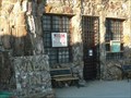
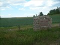
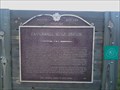 view gallery view gallerySE40.2 km |  Cannonball Stage Station Cannonball Stage Station
in North Dakota Historical Markers This was the fifth stop after Bismarck on the Bismarck-Deadwood Trail. posted by:  WFKellers WFKellers location: North Dakota date approved: 09/02/2009 last visited: 02/10/2010 |
 view gallery view galleryW46.8 km |  The Tin Family - Regent ND The Tin Family - Regent ND
in Roadside Attractions This Roadside Attraction is The Tin Family and it's part of the Enchanted Highway. It's about 1.5 miles north of Regent, North Dakota. posted by: PeterNoG location: North Dakota date approved: 12/19/2011 last visited: 12/14/2021 |
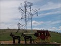 view gallery view galleryW48 km | Theodore Roosevelt Rides Again - Enchanted Highway in Roadside Attractions This Roadside Attraction is Theodore Roosevelt Rides Again and it's part of the Enchanted Highway. It's about 26.6 miles south of I-94 (Exit 72) and 4.9 miles north of Regent, North Dakota. posted by: PeterNoG location: North Dakota date approved: 12/20/2011 last visited: 12/14/2021 |
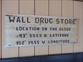 view gallery view gallerySW48.1 km |  N 43° 59.63 W 102° 14.55 - Wall, SD N 43° 59.63 W 102° 14.55 - Wall, SD
in Permanent Geographic Coordinates Permanent Coordinates displayed on the corner of Wall Drug posted by: Bon Echo location: South Dakota date approved: 11/05/2015 last visited: 04/24/2011 |
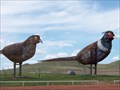 view gallery view galleryW49.1 km | Pheasants on the Prairie - Enchanted Hwy in Roadside Attractions This Roadside Attraction is Pheasants on the Prairie and it's part of the Enchanted Highway. It's about 24.4 miles south of I-94 (Exit 72) and 7 miles north of Regent, North Dakota. posted by: PeterNoG location: North Dakota date approved: 12/20/2011 last visited: 12/14/2021 |
 view gallery view gallery N49.7 km N49.7 km
| Glen Ullin, North Dakota 58631 in U.S. Post Offices This Post Office is located at 115 S Main Street in Glen Ullin, North Dakota. posted by: brwhiz location: North Dakota date approved: 06/30/2013 last visited: never |
 view gallery view gallery S51 km S51 km
| Lemmon, South Dakota 57638 in U.S. Post Offices Small town post office. posted by: NGComets location: South Dakota date approved: 11/01/2011 last visited: never |
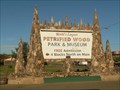
 view gallery view galleryS51 km |  Petrified Wood Park & Museum - Lemmon, SD Petrified Wood Park & Museum - Lemmon, SD
in Science Museums World's Largest Petrified Wood Park and Museum in Lemmon, South Dakota posted by: plainsdrifter358 location: South Dakota date approved: 07/07/2006 last visited: 06/24/2006 |
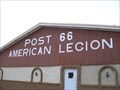 view gallery view galleryS51.2 km |  "American Legion Post 66" Lemmon, South Dakota "American Legion Post 66" Lemmon, South Dakota
in Legion Posts and Branches Named for Henry Brattvet and Melvin Green. posted by: NGComets location: South Dakota date approved: 11/15/2011 last visited: never |
 view gallery view galleryS51.7 km | Petrified Wood Park and Museum Sign in Lemmon, SD in Roadside Attractions Road sign advertising the World's Largest Petrified Wood Park and Museum along US Hwy 12 at the Main Street of Lemmon, SD. posted by: plainsdrifter358 location: South Dakota date approved: 07/05/2006 last visited: 06/04/2003 |
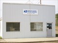 view gallery view galleryS51.8 km | Morristown, South Dakota 57645 in U.S. Post Offices Small town post office. posted by: NGComets location: South Dakota date approved: 11/01/2011 last visited: never |
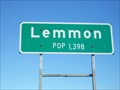 view gallery view galleryS52 km | Lemmon, South Dakota in Population Signs Small town in northern South Dakota. posted by: NGComets location: South Dakota date approved: 11/14/2011 last visited: never |
 view gallery view gallery NW52 km NW52 km
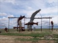
| Fisherman's Dream - Enchanted Highway in Roadside Attractions This Roadside Attraction is Fisherman's Dream and it's part of the Enchanted Highway. It's about 20 miles south of I-94 (Exit 72) and 11.5 miles north of Regent, North Dakota. posted by: PeterNoG location: North Dakota date approved: 12/16/2011 last visited: 12/14/2021 |
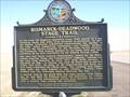 view gallery view gallerySE52.9 km |  Bismarck-Deadwood Stage Trail, Morristown, South Dakota Bismarck-Deadwood Stage Trail, Morristown, South Dakota
in South Dakota Historical Markers Historic marker along US Highway 12. posted by: NGComets location: South Dakota date approved: 11/20/2012 last visited: never |
 view gallery view galleryE55.7 km | Flasher Centennial Railroad Park 1889 ~ 1989 in North Dakota Historical Markers The Northern Pacific Railroad made Flasher, ND a boom town by 1913, three years after the railroad reached Flasher. posted by: plainsdrifter358 location: North Dakota date approved: 07/05/2006 last visited: 05/22/2009 |
 view gallery view galleryNW56.5 km | Grasshopper's Delight in Roadside Attractions This Roadside Attraction is Grasshopper's Delight and it's part of the Enchanted Highway. It's about 15.5 south of I-94 (Exit 72) and 1.3 miles south of Lefor, North Dakota. posted by: PeterNoG location: North Dakota date approved: 12/19/2011 last visited: 12/14/2021 |
 view gallery view galleryE56.8 km | Bismarck to Deadwood Stage Trail in North Dakota Historical Markers This 240 mile route from Bismarck to Deadwood was authorized by the Territorial Legislature in 1877. posted by: plainsdrifter358 location: North Dakota date approved: 07/05/2006 last visited: 09/01/2009 |
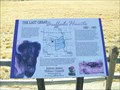 view gallery view gallerySW57.8 km | The Last Great Buffalo Hunt, Haynes, North Dakota in North Dakota Historical Markers The end of the great buffalo herds. posted by: NGComets location: North Dakota date approved: 11/25/2011 last visited: never |
|