 view gallery view gallery NW5.5 km NW5.5 km
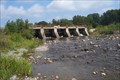
|   Ottertail Lake Dam - Rydal Bank, Ontario Ottertail Lake Dam - Rydal Bank, Ontario
in Water Dams Located along Hwy 638 right within the village. posted by:  Lakeport Lakeport location: Ontario, Canada date approved: 07/01/2008 last visited: never |
 view gallery view gallery W6.6 km W6.6 km
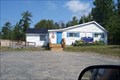
|  "Canadian Legion Branch #211" - Bruce Mines "Canadian Legion Branch #211" - Bruce Mines
in Legion Posts and Branches Only branch in town. posted by: Lakeport location: Ontario, Canada date approved: 08/18/2007 last visited: never |
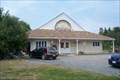
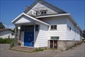
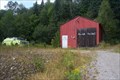
 view gallery view galleryW6.8 km |  Bruce Mines Volunteer Fire Department Bruce Mines Volunteer Fire Department
in Firehouses This location can be found right on Hwy. 17 on the Eastern side of town. posted by: Lakeport location: Ontario, Canada date approved: 06/27/2008 last visited: never |
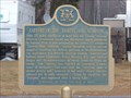
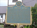 view gallery view galleryW6.8 km |  "THE BRUCE MINES" -- Bruce Mines "THE BRUCE MINES" -- Bruce Mines
in Ontario Provincial Plaques Mining started here in 1847, at what became the first commercially successful copper mine in Canada. posted by: Timo Explorer location: Ontario, Canada date approved: 09/07/2010 last visited: 08/22/2020 |
 view gallery view galleryW6.9 km |  Bruce Mines & Plummer Additional Union Public Library Bruce Mines & Plummer Additional Union Public Library
in Libraries Only location in town. posted by: Lakeport location: Ontario, Canada date approved: 09/05/2007 last visited: never |
 view gallery view gallery SE12.9 km SE12.9 km
| "CAPTURE OF THE "TIGRESS" AND "SCORPION" -- Thessalon in Ontario Provincial Plaques A key naval victory by the British, in the War of 1812. posted by: Timo Explorer location: Ontario, Canada date approved: 04/17/2011 last visited: 07/09/2019 |
 view gallery view gallerySE13.5 km | "CANADIAN LEGION BRANCH 182" - Thessalon, Ontario in Legion Posts and Branches This location isn't hard to find. posted by: Lakeport location: Ontario, Canada date approved: 08/18/2007 last visited: never |
 view gallery view gallery N14.5 km N14.5 km
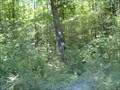
|  Rock Lake Shoe Tree Rock Lake Shoe Tree
in Shoe Trees This tree is in Aberdeen Township. posted by: Lakeport location: Ontario, Canada date approved: 02/11/2007 last visited: never |
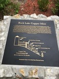 view gallery view galleryN14.6 km |  Rock Lake Copper Mine Rock Lake Copper Mine
in Signs of History Here's a wonderful piece of forgotten history. posted by: Lakeport location: Ontario, Canada date approved: 08/30/2019 last visited: never |
 view gallery view galleryN15.6 km | Havilah Fire Hall in Firehouses Located on Highway 638 between Hwy 670 & Poplar Dale Rd. posted by: Lakeport location: Ontario, Canada date approved: 08/14/2007 last visited: never |
 view gallery view galleryW19.2 km | "RIPPLE ROCK" -- near Desbarats in Ontario Provincial Plaques Explains the geological formation of the unique markings in adjacent sandstone. posted by: Timo Explorer location: Ontario, Canada date approved: 04/17/2011 last visited: 09/08/2022 |
 view gallery view gallery SW23.3 km SW23.3 km
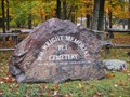
|  WM Wright Memorial Pet Cemetery - St. Joseph Island, ON, Canada WM Wright Memorial Pet Cemetery - St. Joseph Island, ON, Canada
in Pet Cemeteries Pet Cemetery on St. Joseph Island, ON, Canada posted by:  SweetPea57 SweetPea57 location: Ontario, Canada date approved: 01/26/2015 last visited: never |
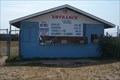 view gallery view galleryNW29.5 km |  Laird International Raceway - Laird, Ontario Laird International Raceway - Laird, Ontario
in Racetracks Short track at its best. posted by: Lakeport location: Ontario, Canada date approved: 07/03/2008 last visited: 07/19/2008 |
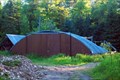 view gallery view galleryW31.9 km |  Neebish Island nearly Goneset Hut Neebish Island nearly Goneset Hut
in Quonset Huts Located on Neebish Island just down the St. Mary's River from the Sault Saint Marie Locks. The ferry runs 4-6 times a day depending on the season and the day of the week. posted by: S5280ft location: Michigan date approved: 07/09/2008 last visited: 12/31/2011 |
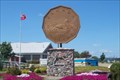 view gallery view galleryNW33.6 km |  Loonie Monument - Hwy 17, Echo Bay Loonie Monument - Hwy 17, Echo Bay
in Ginormous Everyday Objects Ode to the Loonie posted by: Lakeport location: Ontario, Canada date approved: 08/17/2007 last visited: 05/07/2010 |
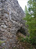 view gallery view gallerySW34.8 km |  Lime Kilns Lime Kilns
in Preserved Architectural Remnants and Ruins The Lime Kilns on Lime Island posted by: Dsprig location: Michigan date approved: 08/26/2015 last visited: never |
 view gallery view gallery S39.6 km S39.6 km
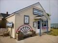
|  Detour Passage - Historical Museum - Michigan, USA Detour Passage - Historical Museum - Michigan, USA
in Official Local Tourism Attractions Detour Passage - Historical Museum - this small museum has a little bit of everything about DeTour, Native American history, and, of course, the ferry and other local marine operations. posted by: veritas vita location: Michigan date approved: 01/08/2013 last visited: 09/23/2016 |
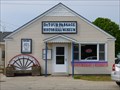 view gallery view galleryS39.6 km |  Detour Passage - Historical Museum - Michigan, USA. Detour Passage - Historical Museum - Michigan, USA.
in History Museums Detour Passage - Historical Museum - Opposite the ferry dock, this small museum has a little bit of everything about DeTour, Native American history, and, of course, the ferry and other local marine operations. posted by: veritas vita location: Michigan date approved: 01/08/2013 last visited: 09/23/2016 |
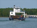 view gallery view galleryS39.6 km |  Drumond Island Ferry - DeTour, Michigan. Drumond Island Ferry - DeTour, Michigan.
in Ferries and Ferry Landings Drumond Island Ferry, Carries 100,000 cars per year across the 'Detour passage of the St Marys River' which leads to Lake Superior, from Lake Huron, and Lake Michigan. posted by: veritas vita location: Michigan date approved: 06/10/2012 last visited: 09/23/2016 |
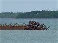 view gallery view galleryS39.9 km |  Shipwreck - DeTour Passage - Michegan. Shipwreck - DeTour Passage - Michegan.
in Shipwrecks Shipwreck JOHN W. CULLEN - The wreck lies in 5 to 40 feet of water, just south of the Sainte Marie wreck, south of DeTour and approximately 600 feet north of Frying Pan Island. It is accessible from shore at a nearby park in DeTour. posted by: veritas vita location: Michigan date approved: 06/10/2012 last visited: 09/23/2016 |
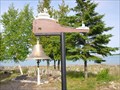 view gallery view galleryS40.4 km |  Gone Missing - Detour - Michigan. Gone Missing - Detour - Michigan.
in Maritime Monuments and Memorials 'Gone Missing' a maritime memorial in the botanical gardens on the shores of the Detour passage of the St Marys river, between Lake Superior and the Huron and Michigan lakes. posted by: veritas vita location: Michigan date approved: 06/11/2012 last visited: 09/23/2016 |
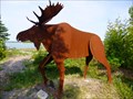 view gallery view galleryS40.4 km |  Marvin the Moose - Detour - Michigan. Marvin the Moose - Detour - Michigan.
in Silhouette Public Art Sculptures Marvin the Moose, a lifesize Silhouette Sculpture, made from sheet steel by local artist Bob Hill. Placed in 2004, in the Botanical Gardens on the shores of Lake Huron, Detour, Michigan. posted by: veritas vita location: Michigan date approved: 05/28/2012 last visited: 09/23/2016 |
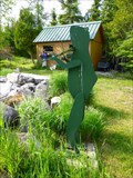 view gallery view galleryS40.4 km | Fiddling Frog - DeTour - Michigan. in Silhouette Public Art Sculptures A silhouette sculpture of a frog playing a fiddle made entirely from sheet steel, painted green. This frog stands approx five feet tall, by the side of a frog pond, located in the botanical gardens on the shores of Lake Huron, DeTour, Michigan posted by: veritas vita location: Michigan date approved: 05/29/2012 last visited: 09/23/2016 |
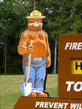 view gallery view galleryS41.2 km |  Smokey Bear - Detour - Michigan. Smokey Bear - Detour - Michigan.
in Smokey Bear Sign Sightings Smokey Bear, on the foreshore of Lake Huron, De Tour State Park, Detour, Michigan. posted by: veritas vita location: Michigan date approved: 05/28/2012 last visited: 09/23/2016 |
 view gallery view galleryS41.2 km | Smokey Bear - Detour - Michigan. USA. in Smokey Bear Sign Sightings A silhouette of Smokey Bear, stands on the foreshore of Lake Huron, De Tour State Park, Detour, Michigan, USA. posted by: luzzi-reloaded location: Michigan date approved: 04/25/2015 last visited: 04/17/2017 |
|