 view gallery view gallery SW2.1 km SW2.1 km
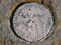
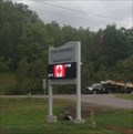
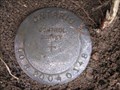
|   CPR Mile 90.68 North Bay Sub Bench Mark CPR Mile 90.68 North Bay Sub Bench Mark
in Canadian Benchmarks CSRS83 Class B Geodetic Horizontal & Vertical Control Bench Mark located at Mile Post 90.68 North Bay Sub of the CPR Line in Rutherglen Ontario posted by:  bandsaw1 bandsaw1 location: Ontario, Canada date approved: 04/04/2010 last visited: never |
 view gallery view gallery E4 km E4 km
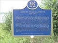
|  "LOUISE DE KIRILINE LAWRENCE 1892-1994" "LOUISE DE KIRILINE LAWRENCE 1892-1994"
in Ontario Provincial Plaques A historical plaque commemorating the contributions of a nearby ornithologist. posted by: Loonwatcher location: Ontario, Canada date approved: 08/27/2018 last visited: never |
 view gallery view gallerySW10.8 km |  Bonfield,ON PO P0H 1E0 Bonfield,ON PO P0H 1E0
in Canada Post Offices Bonfield Post office - Fire Hall - Police (O.P.P.) posted by:  bushman003 bushman003 location: Ontario, Canada date approved: 04/11/2010 last visited: 01/05/2018 |
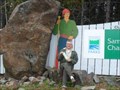 view gallery view galleryE12.9 km |  Samuel de Champlain Provincial Park - Mattawa, Ontario Samuel de Champlain Provincial Park - Mattawa, Ontario
in State/Provincial Parks An Ontario Provincial Park located on Highway 17, halfway between Mattawa and North Bay. posted by: Loonwatcher location: Ontario, Canada date approved: 05/19/2015 last visited: 06/08/2015 |
 view gallery view gallery NE17.5 km NE17.5 km
| BM on MTO Highway 530 - Near Mattawa in Canadian Benchmarks GPS Horizontal Control located along Highway 530 outside of Mattawa. posted by: bandsaw1 location: Ontario, Canada date approved: 05/07/2010 last visited: never |
 view gallery view gallery W20.6 km W20.6 km
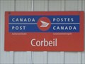
| Corbeil, ON PO P0H 1K0 in Canada Post Offices Rural Postal outlet posted by: bushman003 location: Ontario, Canada date approved: 04/11/2010 last visited: 02/11/2011 |
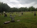 view gallery view gallerySW22.4 km |  St. Thomas D'Aquin Cemetery - Astorville, ON St. Thomas D'Aquin Cemetery - Astorville, ON
in Worldwide Cemeteries Cemetery outside of Astorville, ON posted by: stinger503 location: Ontario, Canada date approved: 08/16/2012 last visited: 09/01/2016 |
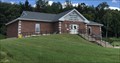 view gallery view gallerySW22.5 km |  East Ferris Public Library - Astorville, ON East Ferris Public Library - Astorville, ON
in Libraries Library for the area of East Ferris posted by: stinger503 location: Ontario, Canada date approved: 08/08/2022 last visited: never |
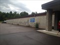 view gallery view gallerySW22.7 km |  Nosbonsing Curling Club - Astorville, ON Nosbonsing Curling Club - Astorville, ON
in Curling Clubs Large curling rink near Lake Nosbonsing posted by: stinger503 location: Ontario, Canada date approved: 08/26/2012 last visited: never |
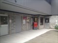 view gallery view gallerySW22.7 km | Astorville PO P0H 1B0 in Canada Post Offices Small post office in rural community centre posted by: stinger503 location: Ontario, Canada date approved: 08/10/2012 last visited: never |
 view gallery view gallerySW22.7 km |  East Ferris Community Centre Time/Temp Sign - Astorville, ON East Ferris Community Centre Time/Temp Sign - Astorville, ON
in Time and Temperature Signs Sign displaying Time and Temperature in Astorville posted by: stinger503 location: Ontario, Canada date approved: 08/10/2012 last visited: never |
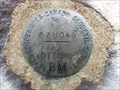 view gallery view gallery NW22.9 km NW22.9 km
| HWY 63 Rock Cut BM# 82U048 in Canadian Benchmarks A First Order Canadian Benchmark posted by: Cargoman location: Ontario, Canada date approved: 09/14/2010 last visited: never |
 view gallery view galleryE23 km | CPR Mile 73.12 North Bay Sub Bench Mark in Canadian Benchmarks Geodetic Vertical Control located at Mile 73.12 North Bay Sub of the Canadian Pacific Railway posted by: bandsaw1 location: Ontario, Canada date approved: 04/04/2010 last visited: never |
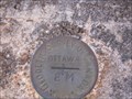
 view gallery view galleryNE23.3 km | CPR Mile 10.92 Temiscaming Sub in Canadian Benchmarks Geodetic Vertical Benchmark located on the CPR Temiscaming Sub at Mile post 10.92 posted by: bandsaw1 location: Québec, Canada date approved: 04/18/2010 last visited: never |
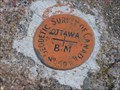 view gallery view galleryNE24.1 km | CPR Mile 9.13 Temiscaming Sub in Canadian Benchmarks Geodetic Vertical Benchmark located at mile 9.13 CPR Temiscaming Sub posted by: bandsaw1 location: Québec, Canada date approved: 04/18/2010 last visited: never |
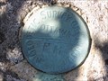
 view gallery view gallery N24.3 km N24.3 km
| Horizontal Control - Midway along MTO Highway 533 in Canadian Benchmarks Horizontal Control for MTO Highway 533 located in a graval pit halfway between Mattawa and Highway 63 along Highway 533 posted by: bandsaw1 location: Ontario, Canada date approved: 05/07/2010 last visited: never |
 view gallery view galleryE24.5 km | CPR Mile 72.27 North Bay Sub Bench Mark in Canadian Benchmarks MTO Geodetic Vertical Benchmark located at MP 72.27 North Bay sub, just east of the switch that leads to the CPR Temiscaming sub. posted by: bandsaw1 location: Ontario, Canada date approved: 04/04/2010 last visited: never |
 view gallery view galleryE24.6 km | CPR Mile 3.01 Temiscaming Sub in Canadian Benchmarks Geodetic Vertical Bench Mark located at Mile Post 3.01 on the CPR Temiscaming Sub posted by: bandsaw1 location: Québec, Canada date approved: 04/18/2010 last visited: never |
 view gallery view galleryE24.8 km |  Musée de Mattawa Museum - Mattawa, ON, Canada Musée de Mattawa Museum - Mattawa, ON, Canada
in History Museums A community museum focusing on local logging, farming, trapping and transportation industries. posted by: Loonwatcher location: Ontario, Canada date approved: 05/30/2015 last visited: 10/05/2022 |
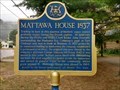 view gallery view galleryE24.8 km | "MATTAWA HOUSE, 1837" - Mattawa, Ontario in Ontario Provincial Plaques Located on the north side of Main Street (Road 533)
just west of the Mattawa River bridge posted by: The Burrow location: Ontario, Canada date approved: 10/05/2022 last visited: never |
 view gallery view galleryE24.8 km | "FRENCH CANADIAN SETTLEMENT AND THE CPR IN THE MATTAWA AREA" in Ontario Provincial Plaques This plaque details the influence that the Canadian Pacific Railway line had on settlement in the Mattawa area. posted by: entogeek location: Ontario, Canada date approved: 09/29/2010 last visited: 10/05/2022 |
 view gallery view galleryNE24.8 km | CPR Mile 12.50 Temiscaming Sub in Canadian Benchmarks Geodetic Vertical Benchmark located on the CPR Temiscaming Sub on the Bridge at Mile Post 12.50 posted by: bandsaw1 location: Québec, Canada date approved: 04/18/2010 last visited: never |
 view gallery view galleryE24.9 km |  "Lest We Forget" War Memorial - Mattawa, Ontario "Lest We Forget" War Memorial - Mattawa, Ontario
in Non-Specific Veteran Memorials A multi-war memorial monument set next to the "forks" in Mattawa. posted by: Loonwatcher location: Ontario, Canada date approved: 12/07/2013 last visited: 03/30/2021 |
 view gallery view galleryE24.9 km | "CANOE ROUTES TO THE WEST" - Mattawa in Ontario Provincial Plaques An OHP detailing the importance of the canoe and fur trading routes in exploring Canada's interior. posted by: Loonwatcher location: Ontario, Canada date approved: 09/04/2013 last visited: 10/05/2022 |
 view gallery view galleryE24.9 km |  Mattawa Route National Historic Event of Canada, Mattawa, Ontario Mattawa Route National Historic Event of Canada, Mattawa, Ontario
in Canadian National Historic Sites This crossroads on the inland waterways the voyageurs frequented had to be one of the most beautiful in Canada. Here one made a hard left when heading up the Ottawa River heading to the interior fur bearing lands and the Canadian West. posted by: colincan location: Ontario, Canada date approved: 05/02/2010 last visited: 10/05/2022 |
|