 view gallery view gallery W0 km W0 km
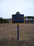
|   Burwash, ON (Ghost town) Burwash, ON (Ghost town)
in Ghost Towns Burwash, Ontario was once the site of a large correctional facility in northern Ontario. posted by:  InGodsHands InGodsHands location: Ontario, Canada date approved: 04/24/2012 last visited: 05/18/2013 |
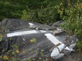
 view gallery view gallery NE4 km NE4 km
|  "BURWASH INDUSTRIAL FARM" - Burwash ON "BURWASH INDUSTRIAL FARM" - Burwash ON
in Ontario Provincial Plaques The Township of Burwash
4 km south of Estaire, turn right onto a military road, which runs west off of Highway 69. Drive for approximately .25 km, turn left and immediately left again. posted by: Treknschmidt location: Ontario, Canada date approved: 04/06/2012 last visited: 05/02/2015 |
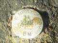
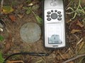
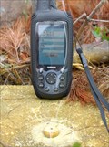
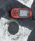
 view gallery view galleryNE11.4 km |  29317 BURWASH FT 29317 BURWASH FT
in Canadian Benchmarks A 1929 1st order marker at the former site of an old forestry tower.
Take highway 69 south from Sudbury Ontario to the village of Estaire. Near the south end of Estaire, take Nepewassi Lake Road eastward to the parking coordinates listed below. posted by:  tec_64 tec_64 location: Ontario, Canada date approved: 09/06/2010 last visited: 09/08/2011 |
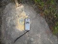
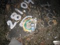
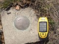
 view gallery view gallery N11.7 km N11.7 km
| Paddy 753006 in Canadian Benchmarks A 1975 first order marker located on a hill near an old Forestry Service tower footing. Drive south from Sudbury, Ontario on Hwy 69. Exit at Estaire Road and continue south on the old highway to Horseshoe Lake road. See further directions below. posted by: tec_64 location: Ontario, Canada date approved: 09/24/2010 last visited: never |
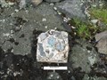
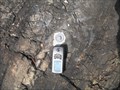
 view gallery view galleryN12.7 km | Geodetic Survey of Canada 73U195 in Canadian Benchmarks Disk along HWY 69 Southeast of Sudbury posted by: bushman003 location: Ontario, Canada date approved: 06/17/2010 last visited: 04/24/2010 |
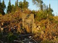 view gallery view galleryN14.5 km |  Bunker exposed due to clearing for Highway 69 Bunker exposed due to clearing for Highway 69
in Earth Homes This bunker was built in 1957. Previously hidden by trees and over growth. posted by: wd57 location: Ontario, Canada date approved: 08/12/2006 last visited: 09/30/2007 |
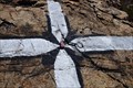
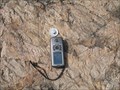
 view gallery view galleryN14.8 km | 73U199 in Canadian Benchmarks A geodetic benchmark located on the west side of old section of hwy 69 north of the Wanapitei River. My measured coordinates are N= 5135620 E= 512355 posted by: broder location: Ontario, Canada date approved: 09/08/2010 last visited: 08/23/2017 |
 view gallery view galleryN15.8 km | 73U200 in Canadian Benchmarks A geodetic benchmark located on the west side of old section hwy 69 opposite the new access road to the new portion of hwy 69 and south of the Horseshoe Lake Rd. The measured coordinates are N= 5136336 E= 510868 posted by: broder location: Ontario, Canada date approved: 09/06/2010 last visited: never |
 view gallery view galleryN20.6 km | 73U203 in Canadian Benchmarks A geodetic Benchmark East of old section of hwy 69 just south of Gladu Road near Geocache GC2DK5X in Greater Sudbury.
Measured coordinates N5141063 E508787 posted by: broder location: Ontario, Canada date approved: 09/04/2010 last visited: 09/03/2010 |
 view gallery view gallery NW22.2 km NW22.2 km
| Broder Geodetic in Canadian Benchmarks Broder Geodetic south of Long Lake. The first Survey Station I found with a Garmin 45 in 1996. posted by: broder location: Ontario, Canada date approved: 03/16/2010 last visited: never |
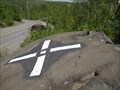
 view gallery view galleryNW22.7 km | The old Ski Hill in Canadian Benchmarks A painted marker on top of the Old Ski Hill looking over Hwy 69. posted by: jwinther location: Ontario, Canada date approved: 05/18/2011 last visited: never |
 view gallery view gallery SE23.7 km SE23.7 km
| Delamere 30300 in Canadian Benchmarks A first order marker located at the center of a former Ontario Forestry Services tower site on a prominent hill located approximately 52 km. SE of Sudbury, Ontario. Please carefully read the note below. posted by: tec_64 location: Ontario, Canada date approved: 09/27/2010 last visited: never |
 view gallery view galleryNW23.8 km | BARE Geodetic in Canadian Benchmarks In Sudbury south of SW buypass 1km east of Long Lake road and near GC1WRX1 posted by: broder location: Ontario, Canada date approved: 11/19/2009 last visited: 03/11/2010 |
 view gallery view galleryNW24.6 km | Sudbury 988004 in Canadian Benchmarks A benchmark located on the west side of Long Lake Road just south of the new HWY 17 buypass overhead. posted by: broder location: Ontario, Canada date approved: 08/30/2010 last visited: never |
 view gallery view galleryNW24.8 km | 820105 in Canadian Benchmarks A bolt & washer on a hill top overlooking Mallard's Landing Subdivision. Easiest way from end Mallards Landing Drive walk South-West. There are 3 Reference Bolts & Washers in close proximity. posted by: broder location: Ontario, Canada date approved: 09/01/2010 last visited: never |
 view gallery view galleryNW25.1 km | 840034 in Canadian Benchmarks A bolt & washer in rock located 31 meters SE Geocache Wallyworld GC29YKD and east of the new Wallmart store on Long Lake Raod. There are 3 reference bolts and washers close by. posted by: broder location: Ontario, Canada date approved: 08/30/2010 last visited: never |
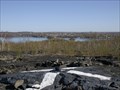
 view gallery view galleryN25.1 km | 73U214 BM Lake Laurentian Conservation Area in Canadian Benchmarks Nice spot over looking Lake Laurentian. Very close to another benchmark. posted by: jwinther location: Ontario, Canada date approved: 11/03/2010 last visited: 02/27/2023 |
 view gallery view galleryN25.1 km | 663402 - NASA in Canadian Benchmarks NASA-GSFC Field Facilities Branch marker listed in the CSRS database.
This is the base and mount for a satellite tracking camera from the mid-sixties. posted by: tec_64 location: Ontario, Canada date approved: 04/16/2006 last visited: 02/27/2023 |
 view gallery view galleryN25.3 km | Sudbury - Fresh Paint in Canadian Benchmarks Accessible by car and a walk of less than 20m. Located right beside the south side of South Bay Road at house number 2319 in Sudbury, Ontario. posted by: tec_64 location: Ontario, Canada date approved: 05/29/2010 last visited: 06/15/2010 |
 view gallery view galleryNW25.7 km | Sudbury 9750028 in Canadian Benchmarks A Rock Bar and Cap on a hilltop north of Treeview road and east of Middle Lake. There are 3 reference bolts and washers located nearby. posted by: broder location: Ontario, Canada date approved: 09/14/2010 last visited: never |
 view gallery view galleryN25.9 km | 730935 in Canadian Benchmarks A second order horizontal control point located on a prominent rock off the ENE end of South Bay Road in Sudbury. posted by: tec_64 location: Ontario, Canada date approved: 04/29/2010 last visited: 06/15/2010 |
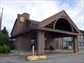 view gallery view galleryNW26.2 km |  Super 8 by Wyndham - Sudbury, ON Super 8 by Wyndham - Sudbury, ON
in Recommended Accommodation Clean, comfortable and economical hotel located in Sudbury's 4 Corners district. posted by: jiggs11 location: Ontario, Canada date approved: 09/02/2020 last visited: never |
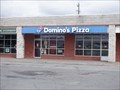 view gallery view galleryNW26.2 km |  Domino's - Sudbury, ON Domino's - Sudbury, ON
in Domino's Pizza Domino's outlet located near the 4 Corners of Sudbury. posted by: jiggs11 location: Ontario, Canada date approved: 09/02/2020 last visited: never |
 view gallery view galleryN26.4 km | Sudbury 64-31 in Canadian Benchmarks A 1964 survey disk posted by: broder location: Ontario, Canada date approved: 04/12/2011 last visited: never |
 view gallery view galleryNW26.6 km | Sudbury 64-15 in Canadian Benchmarks A 1964 Topographical Survey monument located on the South side of Maki Ave and overlooking Nepahwin Lake. The monument has been partially destroyed. posted by: broder location: Ontario, Canada date approved: 11/15/2010 last visited: never |
|