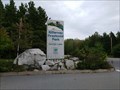
 view gallery view gallery NW8.4 km NW8.4 km
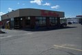
|   Tim Hortons - Hwy. 17 - McKerrow, ON Tim Hortons - Hwy. 17 - McKerrow, ON
in Tim Horton's Restaurants This location is at the junction of Highway 17 & Highway 6. posted by:  Lakeport Lakeport location: Ontario, Canada date approved: 08/19/2007 last visited: 11/07/2013 |
 view gallery view gallery S13.4 km S13.4 km
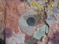
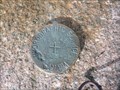
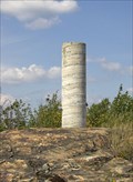
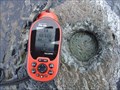
|  8839122 - Isle TP2213 8839122 - Isle TP2213
in Canadian Benchmarks Hydrographic Service posted by: renzotobias location: Ontario, Canada date approved: 08/08/2011 last visited: never |
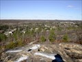
 view gallery view galleryS18.5 km |  Whitefish River First Nation - Whitefish River, Ontario Whitefish River First Nation - Whitefish River, Ontario
in Nations Within Nations Whitefish River First Nation is "A Place of Visions and Dreams" 1,200 Members of Ojibway ancestry with approximately 440 living here on the First Nation. posted by:  Trail Blaisers Trail Blaisers location: Ontario, Canada date approved: 03/14/2014 last visited: 07/22/2019 |
 view gallery view gallery SW31.5 km SW31.5 km
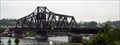
|  Little Current Swing Bridge Little Current Swing Bridge
in Moving Bridges The swing bridge connects Manitoulin Island to Sudbury District. It's the only bridge to the Island posted by: northernpenguin location: Ontario, Canada date approved: 07/26/2010 last visited: 09/07/2022 |
 view gallery view gallerySW31.7 km | Hydrographic Service Canada 8939111 Goat Island, Ontario in Canadian Benchmarks Hydrographic Service Canada medallion numbered 8939111 located on the man made dock in the south west corner of Goat Island, Georgian Bay (Lake Huron), Ontario Canada.
posted by: rlaughton location: Ontario, Canada date approved: 08/13/2008 last visited: never |
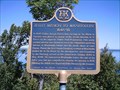
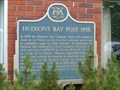 view gallery view gallerySW31.9 km |  "HUDSON'S BAY POST 1856" -- Little Current "HUDSON'S BAY POST 1856" -- Little Current
in Ontario Provincial Plaques Site of Hudson's Bay Post that was never used after it was built, due to opposition from Native leaders. posted by: Timo Explorer location: Ontario, Canada date approved: 06/27/2011 last visited: 08/22/2020 |
 view gallery view gallery SE32.2 km SE32.2 km
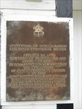
|  Centennial of Confederation of Canada - Killarney Centennial Museum, Killarney, Ontario Centennial of Confederation of Canada - Killarney Centennial Museum, Killarney, Ontario
in Community Commemoration Although the museum has since moved to a neighbouring structure, the original Killarney Centennial Museum was opened in 1967. posted by: Bon Echo location: Ontario, Canada date approved: 12/03/2018 last visited: 08/04/2019 |
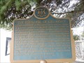 view gallery view gallerySE32.2 km | "THE FOUNDING OF KILLARNEY" in Ontario Provincial Plaques Describes the founding on this small village in the early 1800's posted by: Bon Echo location: Ontario, Canada date approved: 09/28/2017 last visited: 08/04/2019 |
 view gallery view gallerySE32.7 km | Hydrographic Service Canada 9039422 Killarney, Ontario in Canadian Benchmarks Hydrographic Service Canada 9039422 Killarney, Ontario posted by: Treknschmidt location: Ontario, Canada date approved: 11/03/2013 last visited: never |
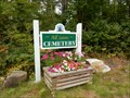 view gallery view gallerySE33 km |  All Saints Cemetery - Killarney, Ontario, Canada All Saints Cemetery - Killarney, Ontario, Canada
in Worldwide Cemeteries Small cemetery near Killarney Ontario. posted by: Bon Echo location: Ontario, Canada date approved: 09/22/2017 last visited: never |
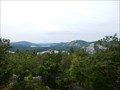 view gallery view gallerySE33.5 km |  The Crack - Killarney PP, Ontario The Crack - Killarney PP, Ontario
in Scenic Overlooks One of the most popular lookouts in Killarney Provincial Park. posted by: Bon Echo location: Ontario, Canada date approved: 09/27/2017 last visited: never |
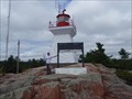 view gallery view gallerySE33.5 km |  Killarney Lightstation - Killarney Ontario Canada Killarney Lightstation - Killarney Ontario Canada
in Coastal Lighthouses Built in 1866 to help warn ships of the Blood Red Gneiss Shoreline ahead. posted by: Juicepig location: Ontario, Canada date approved: 09/08/2008 last visited: 02/12/2019 |
 view gallery view gallerySE33.8 km |  Killarney Provincial Park - Ontario, Canada Killarney Provincial Park - Ontario, Canada
in State/Provincial Parks Ontario Provincial Park posted by: Bon Echo location: Ontario, Canada date approved: 12/03/2018 last visited: 02/12/2019 |
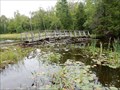 view gallery view gallerySE34.6 km |  The Crack trail footbridge - Killarney PP, Ontario The Crack trail footbridge - Killarney PP, Ontario
in Hiking Path Footbridges Bridge over Kakakise Creek posted by: Bon Echo location: Ontario, Canada date approved: 09/22/2017 last visited: never |
 view gallery view gallery E34.9 km E34.9 km
|  Silver Peak (Killarney Provincial Park) in Ontario, Canada Silver Peak (Killarney Provincial Park) in Ontario, Canada
in Mountain Summits Silver Peak which is 539 meters high, is the 3rd highest mountain in Ontario and is located in Killarney Provincial Park. posted by: res2100 location: Ontario, Canada date approved: 08/30/2005 last visited: 07/13/2011 |
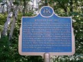
 view gallery view galleryS40.4 km | OHP - "JESUIT MISSION TO MANITOULIN 1648-1650" in Ontario Provincial Plaques A very scenic roadside stop on HWY6 between Little Current and South Baymouth posted by: bwmick location: Ontario, Canada date approved: 08/13/2006 last visited: 07/01/2013 |
 view gallery view gallery NE45.1 km NE45.1 km
| 680287 - Bolted Rock in Canadian Benchmarks Take the trail northward across from Gorman St. in Naughton. Be careful crossing the tracks. It's a good climb. Just follow the trail. Marker is a bolted disk. posted by: tec_64 location: Ontario, Canada date approved: 03/20/2010 last visited: never |
 view gallery view galleryNE45.2 km | OHP - "SALTER'S MERIDIAN 1856" in Ontario Provincial Plaques A roadside stop just west of Sudbury on HWY 55. posted by: bwmick location: Ontario, Canada date approved: 08/13/2006 last visited: 06/25/2011 |
 view gallery view galleryNE45.2 km | OHP - "WHITEFISH LAKE POST" in Ontario Provincial Plaques A small rest area just west of Sudbury on HWY 55 posted by: bwmick location: Ontario, Canada date approved: 08/13/2006 last visited: 06/25/2011 |
 view gallery view galleryNE46.8 km | GSD 963014 Sudbury, ON. in Canadian Benchmarks This is a dual marker pillar. The main marker is a GPS accuracy plate. The old marker (a different number) is an apendage on the side near the bottom. posted by: tec_64 location: Ontario, Canada date approved: 08/18/2006 last visited: 07/15/2019 |
 view gallery view galleryNE47.6 km | 008701701 in Canadian Benchmarks A 1970 Horizontal Second Order mark located on a large moderately-wooded rock hill just south of the town of Lively, Ontario; just west of Sudbury, Ontario. See details below. posted by: tec_64 location: Ontario, Canada date approved: 11/03/2010 last visited: never |
 view gallery view galleryNE47.6 km |  Sudbury Basin - Onaping River Sudbury Basin - Onaping River
in Impact Craters The Sudbury Basin, also known as Sudbury Structure is a major geologic structure in Ontario, Canada. It is the second-largest known impact crater or astrobleme on Earth, as well as one of the oldest. posted by: Skyecat location: Ontario, Canada date approved: 06/11/2012 last visited: 05/19/2013 |
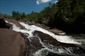 view gallery view galleryNE47.8 km |  Onaping Falls Onaping Falls
in Waterfalls A waterfall made famous by A.Y. Jackson posted by: northernpenguin location: Ontario, Canada date approved: 08/03/2010 last visited: 05/10/2012 |
 view gallery view galleryNE48.9 km | Tim Hortons - Regional Road 24 - Lively, ON in Tim Horton's Restaurants Located in a nice little section of town. posted by: Lakeport location: Ontario, Canada date approved: 08/19/2007 last visited: 04/16/2013 |
 view gallery view galleryNE49.4 km | 70 1714 Lively (Skihill) Control Survey Mark in Canadian Benchmarks Control survey marker on Lively Ski hill. Elevation 310m. posted by: jwinther location: Ontario, Canada date approved: 11/07/2010 last visited: never |
|