 view gallery view gallery SE0.2 km SE0.2 km
|   Tim Horton's - Causley St., Blind River Tim Horton's - Causley St., Blind River
in Tim Horton's Restaurants This location on the North side of Causley Street. posted by:  Lakeport Lakeport location: Ontario, Canada date approved: 08/19/2007 last visited: 01/13/2021 |
 view gallery view gallery NW0.6 km NW0.6 km
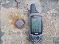
|  Blind River, Ontario - High Rock Hill Triangulation Point Blind River, Ontario - High Rock Hill Triangulation Point
in Canadian Benchmarks Iron spike atop High Rock Hill in Blind River posted by:  Juicepig Juicepig location: Ontario, Canada date approved: 05/14/2010 last visited: 05/11/2010 |
 view gallery view gallery NE32.5 km NE32.5 km
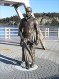
|  Occupational Monument - Elliot Lake Mining Monument Occupational Monument - Elliot Lake Mining Monument
in Occupational Monuments The Elliot Lake Mining Monument pays tribute to the people involved directly and indirectly in the uranium mining industry, and their important contribution to the history of the town of Elliot Lake. posted by: geocite location: Ontario, Canada date approved: 01/28/2009 last visited: 09/06/2020 |
 view gallery view gallery E34.3 km E34.3 km
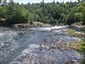
|  Kennebec Falls - Algoma Mills, ON Kennebec Falls - Algoma Mills, ON
in Waterfalls Beautiful cascading waterfall located on the Serpent River in Northern Ontario. posted by: jiggs11 location: Ontario, Canada date approved: 09/05/2020 last visited: 09/08/2022 |
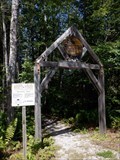 view gallery view galleryE34.3 km |  Kennebec Falls Trailhead - Algoma Mills, ON Kennebec Falls Trailhead - Algoma Mills, ON
in Hiking and walking trailheads Trailhead for the beautiful Kennebec Falls trail. posted by: jiggs11 location: Ontario, Canada date approved: 09/20/2020 last visited: 09/08/2022 |
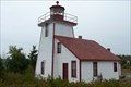 view gallery view gallery SW38.8 km SW38.8 km
|  Mississagi Lighthouse Mississagi Lighthouse
in Coastal Lighthouses The Mississagi Lighthouse on Manatoulin Island on Lake Huron near Meldrum Bay. posted by: Avernar location: Ontario, Canada date approved: 08/29/2008 last visited: 06/25/2011 |
 view gallery view gallery W47 km W47 km
|  "CANADIAN LEGION BRANCH 182" - Thessalon, Ontario "CANADIAN LEGION BRANCH 182" - Thessalon, Ontario
in Legion Posts and Branches This location isn't hard to find. posted by: Lakeport location: Ontario, Canada date approved: 08/18/2007 last visited: never |
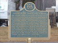 view gallery view galleryW47.6 km |  "CAPTURE OF THE "TIGRESS" AND "SCORPION" -- Thessalon "CAPTURE OF THE "TIGRESS" AND "SCORPION" -- Thessalon
in Ontario Provincial Plaques A key naval victory by the British, in the War of 1812. posted by: Timo Explorer location: Ontario, Canada date approved: 04/17/2011 last visited: 07/09/2019 |
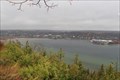 view gallery view gallerySE48.9 km |  Harold Noble Memorial Lookout - Gore Bay, Ontario Harold Noble Memorial Lookout - Gore Bay, Ontario
in Scenic Roadside Look-Outs The Harold Noble Memorial Lookout lookout offers a beautiful view over Gore Bay and to the town of Gore Bay. This photo is from November - it would be great to capture what it looks like in other times of the year. posted by: Trail Blaisers location: Ontario, Canada date approved: 12/01/2013 last visited: 05/23/2005 |
 view gallery view gallerySE62.1 km | OHP - "KAGAWONG MILL -1925-" in Ontario Provincial Plaques A spot near a very nice beach and a very good chocolate shop. posted by: bwmick location: Ontario, Canada date approved: 08/09/2006 last visited: 02/10/2014 |
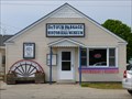
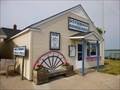
 view gallery view gallerySE62.8 km |  Millstone - Kagawong, Ontario Millstone - Kagawong, Ontario
in Millstones A late 19th century millstone located in the parking area for Bridal Veil Falls. posted by: Trail Blaisers location: Ontario, Canada date approved: 12/01/2013 last visited: 09/07/2022 |
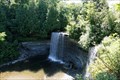 view gallery view gallerySE62.8 km | Bridal Veil Falls - Kagawong, Ontario in Waterfalls Bridal Veil Falls is located in the village of Kagawong on Manatoulin Island. posted by: Avernar location: Ontario, Canada date approved: 09/18/2008 last visited: 09/07/2022 |
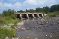 view gallery view galleryW63.6 km |  Ottertail Lake Dam - Rydal Bank, Ontario Ottertail Lake Dam - Rydal Bank, Ontario
in Water Dams Located along Hwy 638 right within the village. posted by: Lakeport location: Ontario, Canada date approved: 07/01/2008 last visited: never |
 view gallery view galleryW65.2 km | "Canadian Legion Branch #211" - Bruce Mines in Legion Posts and Branches Only branch in town. posted by: Lakeport location: Ontario, Canada date approved: 08/18/2007 last visited: never |
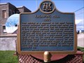
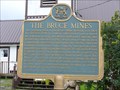 view gallery view galleryW65.2 km | "THE BRUCE MINES" -- Bruce Mines in Ontario Provincial Plaques Mining started here in 1847, at what became the first commercially successful copper mine in Canada. posted by: Timo Explorer location: Ontario, Canada date approved: 09/07/2010 last visited: 08/22/2020 |
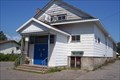
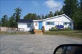
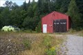
 view gallery view galleryW65.2 km |  Bruce Mines Volunteer Fire Department Bruce Mines Volunteer Fire Department
in Firehouses This location can be found right on Hwy. 17 on the Eastern side of town. posted by: Lakeport location: Ontario, Canada date approved: 06/27/2008 last visited: never |
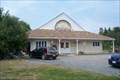 view gallery view galleryW65.5 km |  Bruce Mines & Plummer Additional Union Public Library Bruce Mines & Plummer Additional Union Public Library
in Libraries Only location in town. posted by: Lakeport location: Ontario, Canada date approved: 09/05/2007 last visited: never |
 view gallery view galleryNW66.9 km | Havilah Fire Hall in Firehouses Located on Highway 638 between Hwy 670 & Poplar Dale Rd. posted by: Lakeport location: Ontario, Canada date approved: 08/14/2007 last visited: never |
 view gallery view galleryNW68.2 km |  Rock Lake Shoe Tree Rock Lake Shoe Tree
in Shoe Trees This tree is in Aberdeen Township. posted by: Lakeport location: Ontario, Canada date approved: 02/11/2007 last visited: never |
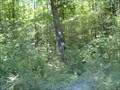
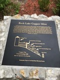 view gallery view galleryNW68.6 km |  Rock Lake Copper Mine Rock Lake Copper Mine
in Signs of History Here's a wonderful piece of forgotten history. posted by: Lakeport location: Ontario, Canada date approved: 08/30/2019 last visited: never |
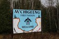 view gallery view gallerySE73.4 km |  M'Chigeeng First Nation - Manitoulin Island, Ontario M'Chigeeng First Nation - Manitoulin Island, Ontario
in Nations Within Nations M'Chigeeng First Nation is an Ojibwe First Nation in the Manitoulin District. posted by: Trail Blaisers location: Ontario, Canada date approved: 12/01/2013 last visited: never |
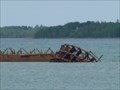 view gallery view galleryW75.8 km |  Shipwreck - DeTour Passage - Michegan. Shipwreck - DeTour Passage - Michegan.
in Shipwrecks Shipwreck JOHN W. CULLEN - The wreck lies in 5 to 40 feet of water, just south of the Sainte Marie wreck, south of DeTour and approximately 600 feet north of Frying Pan Island. It is accessible from shore at a nearby park in DeTour. posted by: veritas vita location: Michigan date approved: 06/10/2012 last visited: 09/23/2016 |
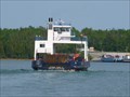 view gallery view galleryW75.8 km |  Drumond Island Ferry - DeTour, Michigan. Drumond Island Ferry - DeTour, Michigan.
in Ferries and Ferry Landings Drumond Island Ferry, Carries 100,000 cars per year across the 'Detour passage of the St Marys River' which leads to Lake Superior, from Lake Huron, and Lake Michigan. posted by: veritas vita location: Michigan date approved: 06/10/2012 last visited: 09/23/2016 |
 view gallery view galleryW75.8 km |  Detour Passage - Historical Museum - Michigan, USA. Detour Passage - Historical Museum - Michigan, USA.
in History Museums Detour Passage - Historical Museum - Opposite the ferry dock, this small museum has a little bit of everything about DeTour, Native American history, and, of course, the ferry and other local marine operations. posted by: veritas vita location: Michigan date approved: 01/08/2013 last visited: 09/23/2016 |
 view gallery view galleryW75.8 km |  Detour Passage - Historical Museum - Michigan, USA Detour Passage - Historical Museum - Michigan, USA
in Official Local Tourism Attractions Detour Passage - Historical Museum - this small museum has a little bit of everything about DeTour, Native American history, and, of course, the ferry and other local marine operations. posted by: veritas vita location: Michigan date approved: 01/08/2013 last visited: 09/23/2016 |
|