 view gallery view gallery NE3.1 km NE3.1 km
|   Delamere 30300 Delamere 30300
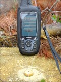
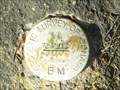
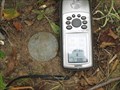
in Canadian Benchmarks A first order marker located at the center of a former Ontario Forestry Services tower site on a prominent hill located approximately 52 km. SE of Sudbury, Ontario. Please carefully read the note below. posted by:  tec_64 tec_64 location: Ontario, Canada date approved: 09/27/2010 last visited: never |
 view gallery view gallery S9.8 km S9.8 km
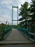
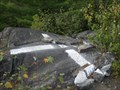
|  LARGEST - French River Snowmobile Bridge - Canada LARGEST - French River Snowmobile Bridge - Canada
in Superlatives The largest snowmobile bridge in the world, or simply the largest cable supported snowmobile bridge in Canada? posted by: Bon Echo location: Ontario, Canada date approved: 10/13/2017 last visited: 05/27/2018 |
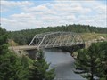 view gallery view galleryS10 km |  French River Bridge on Trans-Canada Highway French River Bridge on Trans-Canada Highway
in Truss Bridges Truss Bridge over the historic French River, the path of the Voyageurs. posted by:  Skyecat Skyecat location: Ontario, Canada date approved: 07/18/2011 last visited: 08/29/2017 |
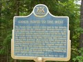 view gallery view galleryS10.1 km |  "CANOE ROUTE TO THE WEST" "CANOE ROUTE TO THE WEST"
in Ontario Provincial Plaques The French River formed the most important link for early explorers and fur-traders, to reach the lands and waterways to the west. posted by: Timo Explorer location: Ontario, Canada date approved: 09/07/2010 last visited: 08/19/2020 |
 view gallery view galleryS10.1 km |  "PIERRE-ESPRIT RADISSON" c1640-1710 In 1659 -- French River, Ontario "PIERRE-ESPRIT RADISSON" c1640-1710 In 1659 -- French River, Ontario
in Canadian National Historic Sites Fur trader and explorer, helped found the Hudson's Bay Company, 1670. posted by: Timo Explorer location: Ontario, Canada date approved: 09/07/2010 last visited: 08/29/2017 |
 view gallery view galleryS10.1 km |  French River - Ontario, Canada French River - Ontario, Canada
in National Wild and Scenic Rivers The 110 km French River was the first river to be designated to the Canadian Heritage Rivers System in 1986 (source: chrs.ca/the-rivers/french/designation/) posted by: Bon Echo location: Ontario, Canada date approved: 09/24/2017 last visited: 07/08/2023 |
 view gallery view galleryNE18.8 km |  Shoe Tree HWY 535 in Northern Ontario Shoe Tree HWY 535 in Northern Ontario
in Shoe Trees A shoe tree in Northern Ontario posted by: The Burrow location: Ontario, Canada date approved: 09/20/2017 last visited: 06/23/2018 |
 view gallery view gallery NW23 km NW23 km
| "BURWASH INDUSTRIAL FARM" - Burwash ON in Ontario Provincial Plaques The Township of Burwash
4 km south of Estaire, turn right onto a military road, which runs west off of Highway 69. Drive for approximately .25 km, turn left and immediately left again. posted by: Treknschmidt location: Ontario, Canada date approved: 04/06/2012 last visited: 05/02/2015 |
 view gallery view galleryNW23.3 km |  Burwash, ON (Ghost town) Burwash, ON (Ghost town)
in Ghost Towns Burwash, Ontario was once the site of a large correctional facility in northern Ontario. posted by: InGodsHands location: Ontario, Canada date approved: 04/24/2012 last visited: 05/18/2013 |
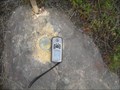
 view gallery view galleryNW26.1 km | 29317 BURWASH FT in Canadian Benchmarks A 1929 1st order marker at the former site of an old forestry tower.
Take highway 69 south from Sudbury Ontario to the village of Estaire. Near the south end of Estaire, take Nepewassi Lake Road eastward to the parking coordinates listed below. posted by: tec_64 location: Ontario, Canada date approved: 09/06/2010 last visited: 09/08/2011 |
 view gallery view galleryNW31.5 km | Geodetic Survey of Canada 73U195 in Canadian Benchmarks Disk along HWY 69 Southeast of Sudbury posted by: bushman003 location: Ontario, Canada date approved: 06/17/2010 last visited: 04/24/2010 |
 view gallery view galleryNW33.5 km | Paddy 753006 in Canadian Benchmarks A 1975 first order marker located on a hill near an old Forestry Service tower footing. Drive south from Sudbury, Ontario on Hwy 69. Exit at Estaire Road and continue south on the old highway to Horseshoe Lake road. See further directions below. posted by: tec_64 location: Ontario, Canada date approved: 09/24/2010 last visited: never |
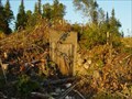 view gallery view galleryNW33.6 km |  Bunker exposed due to clearing for Highway 69 Bunker exposed due to clearing for Highway 69
in Earth Homes This bunker was built in 1957. Previously hidden by trees and over growth. posted by: wd57 location: Ontario, Canada date approved: 08/12/2006 last visited: 09/30/2007 |
 view gallery view galleryNW34.3 km | 73U199 in Canadian Benchmarks A geodetic benchmark located on the west side of old section of hwy 69 north of the Wanapitei River. My measured coordinates are N= 5135620 E= 512355 posted by: broder location: Ontario, Canada date approved: 09/08/2010 last visited: 08/23/2017 |
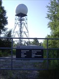 view gallery view galleryS35.2 km |  Environment Canada - Britt Radar Environment Canada - Britt Radar
in Weather Radars Environment Canada's radar station for the Near North districts posted by: northernpenguin location: Ontario, Canada date approved: 07/27/2010 last visited: 02/18/2015 |
 view gallery view galleryNW35.9 km | 73U200 in Canadian Benchmarks A geodetic benchmark located on the west side of old section hwy 69 opposite the new access road to the new portion of hwy 69 and south of the Horseshoe Lake Rd. The measured coordinates are N= 5136336 E= 510868 posted by: broder location: Ontario, Canada date approved: 09/06/2010 last visited: never |
 view gallery view galleryNW40.9 km | 73U203 in Canadian Benchmarks A geodetic Benchmark East of old section of hwy 69 just south of Gladu Road near Geocache GC2DK5X in Greater Sudbury.
Measured coordinates N5141063 E508787 posted by: broder location: Ontario, Canada date approved: 09/04/2010 last visited: 09/03/2010 |
 view gallery view gallery N41.7 km N41.7 km
| CPR Cartier Sub MP 49.65 in Canadian Benchmarks CPR Railway Cartier Sub, Mile Post 49.65 posted by: bandsaw1 location: Ontario, Canada date approved: 03/28/2010 last visited: never |
 view gallery view galleryN42 km | CPR Cartier Sub MP 52.20 in Canadian Benchmarks 1921 CGC Survey Bolt located at Mile 52.20 of CPR Cartier Subdivision posted by: bandsaw1 location: Ontario, Canada date approved: 03/28/2010 last visited: never |
 view gallery view galleryNE42.6 km | CPR BM loacted at Mile 47.16 CPR Cartier Sub in Canadian Benchmarks Geodetic Vertical Benchmark located at Mile 47.16 on the CPR Cartier Subdivision posted by: bandsaw1 location: Ontario, Canada date approved: 04/26/2010 last visited: never |
 view gallery view galleryNE42.6 km | CPR BM Located at MP 46.20 Cartier Sub in Canadian Benchmarks A 1970 Geodetic Vertical Benchmark located at Mile 46.20 on the CPR Cartier Subdivsion. posted by: bandsaw1 location: Ontario, Canada date approved: 04/26/2010 last visited: never |
 view gallery view galleryNE43.8 km | MP 44.05 CPR Cartier Sub in Canadian Benchmarks 1921 CGC Railway Survey Bench Mark located at Mile Post 44.05 Cartier Subdivision, CPR Railway posted by: bandsaw1 location: Ontario, Canada date approved: 04/12/2010 last visited: never |
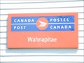 view gallery view galleryN44.1 km |  Wahnapitae P.O. P0M 3C0 Wahnapitae P.O. P0M 3C0
in Canada Post Offices Wahnapitae Post office posted by: bushman003 location: Ontario, Canada date approved: 06/19/2010 last visited: 02/10/2011 |
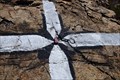 view gallery view galleryNW44.7 km | The old Ski Hill in Canadian Benchmarks A painted marker on top of the Old Ski Hill looking over Hwy 69. posted by: jwinther location: Ontario, Canada date approved: 05/18/2011 last visited: never |
 view gallery view galleryN45.1 km | CPR BM Located at Mile 58.23 Cartier Sub in Canadian Benchmarks Geodetic Vertical Benchmark located at Mile Post 58.23 on the CPR Cartier Subdivision posted by: bandsaw1 location: Ontario, Canada date approved: 04/26/2010 last visited: never |
|