 view gallery view gallery N2.7 km N2.7 km
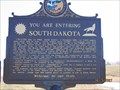
|   You are entering South Dakota (2) You are entering South Dakota (2)
in South Dakota Historical Markers Welcome to South Dakota! Created with its twin North Dakota, 2 November 1889, its 77,047 square miles ranks 15th in size. posted by:  MNSearchers MNSearchers location: South Dakota date approved: 04/16/2007 last visited: 09/15/2019 |
 view gallery view galleryN2.7 km | You are entering Roberts County South Dakota 4 in South Dakota Historical Markers Long the home of Sisseton, Wahpeton & Cuthead Yanktonaise Sioux, it became part of Deuel & Cheyenne Counties in 1862. posted by: MNSearchers location: South Dakota date approved: 04/16/2007 last visited: 09/15/2019 |
 view gallery view galleryN2.7 km | You are now leaving South Dakota in South Dakota Historical Markers You are now leaving South Dakota posted by: MNSearchers location: South Dakota date approved: 04/16/2007 last visited: 09/15/2019 |
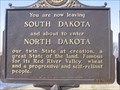
 view gallery view galleryN2.7 km | You are about to enter Richland County ND in South Dakota Historical Markers The southerly most 4 miles of Richland County posted by: MNSearchers location: South Dakota date approved: 04/16/2007 last visited: 09/15/2019 |
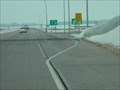
 view gallery view galleryN2.7 km |  ND / SD on State Hwy 127 ND / SD on State Hwy 127
in Border Crossings This quiet Border Crossing is on State Highway 127 between North Dakota and South Dakota. posted by: PeterNoG location: South Dakota date approved: 12/27/2011 last visited: 09/15/2019 |
 view gallery view gallery E4 km E4 km
|  White Rock South Dakota White Rock South Dakota
in Ghost Towns Ghost Town. In 2000 the census had the population of 18 and in recent years I understand there is only like 2 people here now. posted by: MNSearchers location: South Dakota date approved: 04/17/2007 last visited: 11/13/2011 |
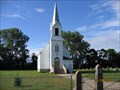
 view gallery view galleryE4 km |  Augustana Lutheran Church - SD Augustana Lutheran Church - SD
in Country Churches A church located in the ghost town of.... posted by: MNSearchers location: South Dakota date approved: 04/19/2007 last visited: 04/19/2007 |
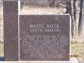
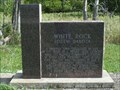 view gallery view galleryE4.2 km | White Rock, South Dakota in South Dakota Historical Markers This historical marker features the now very small town of White Rock, located along the Bois de Sioux River in Roberts County, South Dakota. posted by: Marine Biologist location: South Dakota date approved: 08/31/2009 last visited: 11/13/2011 |
 view gallery view galleryE4.2 km |  White Rock, South Dakota White Rock, South Dakota
in Wikipedia Entries The town of White Rock, South Dakota, once had a population of 600. Today's it's essentially a ghost town with a population of only 18 people documented during the 2000 census. posted by: Marine Biologist location: South Dakota date approved: 09/05/2009 last visited: 11/13/2011 |
 view gallery view gallery NE5.3 km NE5.3 km
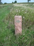
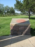
|  Minnesota - North Dakota - South Dakota Tri-point Witness Monument Minnesota - North Dakota - South Dakota Tri-point Witness Monument
in U.S. Historic Survey Stones and Monuments A stone post marking the location where the states of Minnesota, North Dakota, and South Dakota meet near White Rock, South Dakota. However, the monument appears to actually be located in the state of North Dakota. posted by: Marine Biologist location: North Dakota date approved: 09/02/2009 last visited: 08/25/2023 |
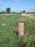 view gallery view galleryNE5.3 km |  Tripoint - Minnesota, North Dakota, and South Dakota Tripoint - Minnesota, North Dakota, and South Dakota
in Tripoints and Multipoints A stone post marks the location where the states of Minnesota, North Dakota, and South Dakota meet near White Rock, South Dakota. posted by: Marine Biologist location: North Dakota date approved: 03/12/2012 last visited: 08/25/2023 |
 view gallery view gallery SW7.2 km SW7.2 km
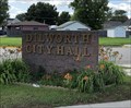
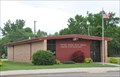
|  Dilworth, MN Dilworth, MN
in City and Town Halls This City Hall is located one block south of Center Ave. on Main Street posted by: m&m O location: Minnesota date approved: 07/03/2020 last visited: never |
 view gallery view gallerySW9.8 km |  Rosholt, South Dakota 57260 Rosholt, South Dakota 57260
in U.S. Post Offices Small town post office. posted by: NGComets location: South Dakota date approved: 07/19/2012 last visited: never |
 view gallery view gallerySW9.8 km |  Black Sheep Burger Company - Rosholt, SD Black Sheep Burger Company - Rosholt, SD
in Best Burgers in Town Located on the south side of highway 127 as it runs through Rosholt. posted by: m&m O location: South Dakota date approved: 06/16/2020 last visited: never |
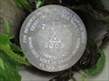 view gallery view galleryE11.1 km |  7806 F 7806 F
in U.S. Benchmarks Minnesota Department of Transportation geodetic control mark in Monson Township. posted by: msrubble location: Minnesota date approved: 01/07/2015 last visited: never |
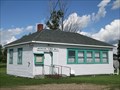 view gallery view galleryE11.1 km | Monson Township, Minnesota in City and Town Halls Town hall for Monson Township, Traverse County, Minnesota. posted by: msrubble location: Minnesota date approved: 01/05/2015 last visited: never |
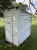 view gallery view galleryE11.1 km |  Former School House Outhouse - Wheaton, MN Former School House Outhouse - Wheaton, MN
in Outhouses This outhouse is behind the Monson Town Hall in Traverse County. posted by: m&m O location: Minnesota date approved: 11/27/2021 last visited: never |
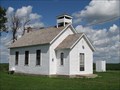 view gallery view galleryNE14.2 km |  District No. 44 School - Taylor Township, Minnesota District No. 44 School - Taylor Township, Minnesota
in One-Room Schoolhouses One-room schoolhouse near Tintah, Minnesota. posted by: msrubble location: Minnesota date approved: 01/09/2015 last visited: never |
 view gallery view gallery W16.1 km W16.1 km
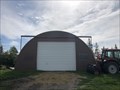
|  City Park Quonset Hut - Fargo, ND City Park Quonset Hut - Fargo, ND
in Quonset Huts Soccer Complex Quonset Hut. posted by: m&m O location: North Dakota date approved: 08/06/2019 last visited: never |
 view gallery view galleryN16.1 km | Fairmount, North Dakota 58030 in U.S. Post Offices This Post Office is located at 202 Main Avenue in Fairmount, North Dakota. posted by: brwhiz location: North Dakota date approved: 06/29/2013 last visited: never |
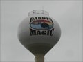 view gallery view galleryW16.7 km |  Dakota Magic Water Tower – Hankinson, North Dakota Dakota Magic Water Tower – Hankinson, North Dakota
in Water Towers This colorful water tower overlooks the Dakota Magic Casino just a stones throw from Hwy. 29 on the border of North and South Dakotas posted by:  wildernessmama wildernessmama location: North Dakota date approved: 08/19/2011 last visited: 07/16/2019 |
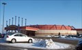 view gallery view galleryW16.7 km |  Dakota Magic Casino - Hankinson ND Dakota Magic Casino - Hankinson ND
in Casinos This casino is 9 miles south of Hankinson just off I-29 Exit 1 in North Dakota. posted by: PeterNoG location: North Dakota date approved: 01/17/2008 last visited: 07/16/2019 |
 view gallery view galleryW17.2 km | ND/SD on I-29 in Border Crossings This busy state border crossing is only Interstate that connects North Dakota and South Dakota. posted by: PeterNoG location: North Dakota date approved: 06/06/2011 last visited: 12/17/2016 |
 view gallery view galleryW18.7 km | Glacial Lakes Rest Stop – New Effington, SD in South Dakota Historical Markers This historical marker is located on the southbound rest area along I-29 south of the North Dakota/South Dakota border. posted by: wildernessmama location: South Dakota date approved: 09/27/2011 last visited: 06/12/2017 |
 view gallery view galleryW21.2 km | Walla Lutheran Church - SD in Country Churches This quaint little Church was just over the ND/SD border near New Effington SD. posted by: MNSearchers location: South Dakota date approved: 06/25/2006 last visited: 06/25/2006 |
|