 view gallery view gallery SE0.3 km SE0.3 km
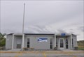
|   Reed Point, Montana 59069 Reed Point, Montana 59069
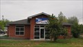
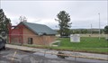
in U.S. Post Offices This Post Office is located at 3 Division Street in Reed Point, Montana. posted by:  brwhiz brwhiz location: Montana date approved: 01/27/2013 last visited: never |
 view gallery view gallery W1.6 km W1.6 km
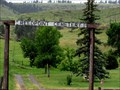
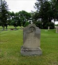
|  Reed Point Cemetery - Reed Point, Montana Reed Point Cemetery - Reed Point, Montana
in Worldwide Cemeteries Reed Point Cemetery is SW of Reed Point north of Hwy. 90. You will need to access the cemetery from Hump Creek Road. You can see the cemetery from the highway. posted by: T0SHEA location: Montana date approved: 01/27/2018 last visited: never |
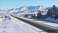
 view gallery view galleryW1.6 km |  Solar plants nearly complete in Reed Point and Hardin Solar plants nearly complete in Reed Point and Hardin
in News Article Locations Driving down I-90 between Big Timber and Columbus this spring we came across our first solar farm. posted by: T0SHEA location: Montana date approved: 09/10/2017 last visited: never |
 view gallery view galleryW1.6 km |  River Bend Solar Farm - Reed Point, MT River Bend Solar Farm - Reed Point, MT
in Solar Power Driving down I-90 between Big Timber and Columbus this spring we came across our first solar farm. posted by: T0SHEA location: Montana date approved: 09/10/2017 last visited: never |
 view gallery view galleryW2.7 km |  Reed Point East Web Camera - Reed Point, MT Reed Point East Web Camera - Reed Point, MT
in Web Cameras This is one of 73 (as of January 2017) Road Weather Information System camera sites operated by the Montana Department of Transportation to aid motorists as they make their way across BIG SKY Country. posted by: T0SHEA location: Montana date approved: 02/07/2017 last visited: never |
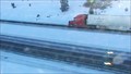 view gallery view galleryW2.7 km | Reed Point Roadway Web Camera - Reed Point, MT in Web Cameras This is one of 73 (as of January 2017) Road Weather Information System camera sites operated by the Montana Department of Transportation to aid motorists as they make their way across BIG SKY Country. posted by: T0SHEA location: Montana date approved: 02/07/2017 last visited: never |
 view gallery view galleryW2.9 km | Reed Point West Web Camera - Reed Point, MT in Web Cameras This is one of 73 (as of January 2017) Road Weather Information System camera sites operated by the Montana Department of Transportation to aid motorists as they make their way across BIG SKY Country. posted by: T0SHEA location: Montana date approved: 02/07/2017 last visited: never |
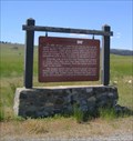 view gallery view galleryW13.7 km |  Thomas Party Killing on Bridger Trail, Montana Thomas Party Killing on Bridger Trail, Montana
in Montana Historical Markers In 1865 William Thomas, his son Charles, and a driver named Schultz were killed at this spot by hostile Indians. Emigrants found the bodies and buried them in one grave. posted by: Rose Red location: Montana date approved: 10/19/2008 last visited: never |
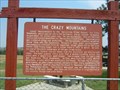 view gallery view galleryW16.9 km | Crazy Mountains in Montana Historical Markers Historical marker commemorating the Crazy Mountains and their role though history. posted by:  BruceS BruceS location: Montana date approved: 08/28/2007 last visited: 05/25/2009 |
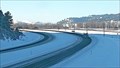
 view gallery view galleryW16.9 km |  Greycliff Eastbound Rest Area Greycliff Eastbound Rest Area
in Highway Rest Areas This Rest Area is located on the south side of Interstate 90 about 4 miles southeast of Greycliff, Montana. posted by: brwhiz location: Montana date approved: 12/18/2012 last visited: never |
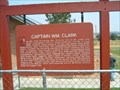 view gallery view galleryW16.9 km | Captain Wm. Clark in Montana Historical Markers Historical marker commemorating the Lewis and Clark Expedition which had passed through the area. posted by: BruceS location: Montana date approved: 08/28/2007 last visited: 05/31/2006 |
 view gallery view galleryW16.9 km |  Greycliff Eastbound Rest Area Greycliff Eastbound Rest Area
in 'You Are Here' Maps You Are Here at the Greycliff Rest Area on the south side of Interstate 90 about 4 miles southeast of Greycliff, Montana. posted by: brwhiz location: Montana date approved: 12/18/2012 last visited: never |
 view gallery view galleryW16.9 km | Greycliff Westbound Rest Area in Highway Rest Areas This Rest Area is located on the north side of Interstate 90 about 4 miles southeast of Greycliff, Montana. posted by: brwhiz location: Montana date approved: 12/18/2012 last visited: 09/30/2016 |
 view gallery view galleryW16.9 km | Greycliff Westbound Rest Area in 'You Are Here' Maps You Are Here at the Greycliff Rest Area on the north side of Interstate 90 about 4 miles southeast of Greycliff, Montana. posted by: brwhiz location: Montana date approved: 12/18/2012 last visited: never |
 view gallery view galleryW19.8 km | Greycliff, Montana 59033 in U.S. Post Offices This Post Office is located at 217 A Street in Greycliff, Montana. posted by: brwhiz location: Montana date approved: 01/27/2013 last visited: 10/30/2016 |
 view gallery view galleryW20.4 km | Greycliff Prairie Dog Town State Park in 'You Are Here' Maps You Are Here at the entrance to Greycliff Prairie Dog Town State Park on the south side of Interstate 90 directly west of Greycliff, Montana. posted by: brwhiz location: Montana date approved: 12/18/2012 last visited: never |
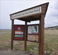 view gallery view galleryW20.4 km |  Greycliff Prairie Dog Town State Park - Montana Greycliff Prairie Dog Town State Park - Montana
in State/Provincial Parks Greycliff Prairie Dog Town State Park is located on the south side of Interstate 90 directly west of Greycliff, Montana. posted by: brwhiz location: Montana date approved: 12/27/2012 last visited: 08/13/2017 |
 view gallery view gallery E22.2 km E22.2 km
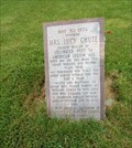
|  Mrs. Lucy Chute - Columbus, Montana Mrs. Lucy Chute - Columbus, Montana
in Citizen Memorials Mrs. Lucy Chute citizen memorial is located in the Mountain View Cemetery west of Columbus on old Hwy. 10. posted by: T0SHEA location: Montana date approved: 01/14/2018 last visited: never |
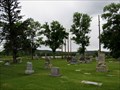 view gallery view galleryE22.2 km | Mountain View Cemetery - Columbus, Montana in Worldwide Cemeteries Mountain View Cemetery is located west of Columbus on Old Hwy. 10, not far from downtown. posted by: T0SHEA location: Montana date approved: 01/14/2018 last visited: never |
 view gallery view galleryE22.2 km |  Mountain View Cemetery - Columbus, MT Mountain View Cemetery - Columbus, MT
in U.S. National Register of Historic Places Just west of Columbus on Old Highway 10, this otherwise unremarkable cemetery has been entered in the National Register. posted by: T0SHEA location: Montana date approved: 04/27/2019 last visited: never |
 view gallery view galleryE22.2 km |  John Shaw - Mountain View Cemetery - Columbus, Montana, United States John Shaw - Mountain View Cemetery - Columbus, Montana, United States
in Doves of peace Mountain View Cemetery is located west of Columbus on Old Hwy. 10, not far from downtown. posted by: T0SHEA location: Montana date approved: 01/14/2018 last visited: never |
 view gallery view gallery S22.7 km S22.7 km
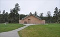
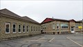
| Sandstone and Cobblestone Schools - Absarokee, MT in U.S. National Register of Historic Places Designed by an engineer and built of local materials by volunteers, Absarokee's old Cobblestone School served as the town's high school until its closing in 1990. It was preceded by the Sandstone School, built in 1910. posted by: T0SHEA location: Montana date approved: 07/22/2017 last visited: never |
 view gallery view galleryS22.7 km |  Former Cobblestone High School - Absarokee, MT Former Cobblestone High School - Absarokee, MT
in Former Schools Designed by an engineer and built of local materials by volunteers, Absarokee's old Cobblestone School served as the town's high school until its closing in 1990. posted by: T0SHEA location: Montana date approved: 07/22/2017 last visited: never |
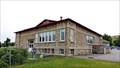
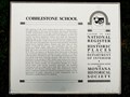 view gallery view galleryS22.7 km | Cobblestone School - Absarokee, MT in Montana Historical Markers Designed by an engineer and built of local materials by volunteers, Absarokee's old Cobblestone School served as the town's high school until its closing in 1990. It was preceded by the Sandstone School, built in 1910. posted by: T0SHEA location: Montana date approved: 07/27/2017 last visited: never |
 view gallery view galleryS22.7 km |  Cobblestone School - Absarokee, MT Cobblestone School - Absarokee, MT
in Cobblestone Buildings Designed by an engineer and built of local materials by volunteers, Absarokee's old Cobblestone School served as the town's high school until its closing in 1990. posted by: T0SHEA location: Montana date approved: 07/23/2017 last visited: never |
|