 view gallery view gallery SE2.1 km SE2.1 km
|   Mist Falls Lodge remains Mist Falls Lodge remains
in Lonely Chimneys A lonely chimney along the Columbia Scenic highway..just east of mm 31. posted by:  rnrgrl rnrgrl location: Oregon date approved: 07/02/2010 last visited: 11/05/2013 |
 view gallery view gallerySE2.4 km |  Wahkeena Falls You Are Here Map Wahkeena Falls You Are Here Map
in 'You Are Here' Maps A you are here map near the parking area for Wahkeena Falls. posted by:  BruceS BruceS location: Oregon date approved: 03/02/2009 last visited: 07/10/2017 |
 view gallery view gallerySE2.6 km |  Wahkeena Falls - Columbia River Gorge Highway - Multnomah County, Oregon Wahkeena Falls - Columbia River Gorge Highway - Multnomah County, Oregon
in American Guide Series Cascade style falls along the Historic Columbia River Gorge Highway. posted by: BruceS location: Oregon date approved: 03/01/2009 last visited: 07/10/2017 |
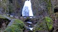
 view gallery view gallerySE2.6 km |  Wahkeena Falls Footbridge and Masonry Guard Walls - Columbia River Highway Historic District Wahkeena Falls Footbridge and Masonry Guard Walls - Columbia River Highway Historic District
in NRHP Historic Districts - Contributing Buildings Stone footbridge directly in front of Wahkeena Falls. posted by: BruceS location: Oregon date approved: 03/01/2009 last visited: 01/02/2014 |
 view gallery view gallerySE2.6 km |  Wahkeena Falls - Oregon Wahkeena Falls - Oregon
in Wikipedia Entries Cascade style falls along the Historic Columbia River Gorge Highway. posted by: BruceS location: Oregon date approved: 02/15/2010 last visited: 07/10/2017 |
 view gallery view gallerySE2.6 km |  Wahkeena Falls - Columbia River Gorge Highway - Multnomah County, Oregon Wahkeena Falls - Columbia River Gorge Highway - Multnomah County, Oregon
in Waterfalls Cascade style falls along the Historic Columbia River Gorge Highway.
posted by: BruceS location: Oregon date approved: 03/02/2009 last visited: 10/03/2019 |
 view gallery view gallerySE2.6 km |  Wahkeena Falls Footbridge, Columbia River Highway, Oregon Wahkeena Falls Footbridge, Columbia River Highway, Oregon
in Stone Bridges This 100 year old stone bridge is going strong. posted by: DocDTA location: Oregon date approved: 12/29/2013 last visited: 07/10/2017 |
 view gallery view gallerySE2.6 km |  Wahkeena Falls Footbridge - Columbia River Highway Wahkeena Falls Footbridge - Columbia River Highway
in Hiking Path Footbridges Stone footbridge directly in front of Wahkeena Falls. posted by: BruceS location: Oregon date approved: 03/02/2009 last visited: 07/10/2017 |
 view gallery view gallery E3.1 km E3.1 km
|  I-84 Rest Area, Multnomah Falls, Oregon I-84 Rest Area, Multnomah Falls, Oregon
in Highway Rest Areas Part of the Multnomah Falls Rest Area is located on the north side of the railroad tracks and the other part on the south side. posted by: Rose Red location: Oregon date approved: 05/30/2007 last visited: 12/29/2022 |
 view gallery view galleryE3.1 km |  I-84 Rest Area, Multnomah Falls, Oregon I-84 Rest Area, Multnomah Falls, Oregon
in Blue Star Memorial Highway Markers This Blue Star Marker, a tribute to the Armed Forces that have defended the United States of America, is located north of Multnomah Falls. posted by: Rose Red location: Oregon date approved: 04/05/2007 last visited: 12/29/2022 |
 view gallery view galleryE3.1 km |  Multnomah Falls Lodge Restaurant reopens Multnomah Falls Lodge Restaurant reopens
in News Article Locations The reopening of the restaurant at the Multnomah Falls Lodge. posted by: saopaulo1 location: Oregon date approved: 07/07/2022 last visited: 12/29/2022 |
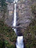
 view gallery view galleryE3.2 km |  Multnomah Falls Lodge and Footpath, Oregon Multnomah Falls Lodge and Footpath, Oregon
in U.S. National Register of Historic Places Multnomah Falls Lodge built in 1925 (improved 1994) and Footpath are located northeast of Bridal Veil on the Historic Columbia River Highway. posted by: Rose Red location: Oregon date approved: 06/23/2006 last visited: 12/29/2022 |
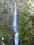
 view gallery view galleryE3.2 km |  Multnomah Falls, Oregon Multnomah Falls, Oregon
in Photos Then and Now Multnomah Falls has been a favorite photo spot for well over the last 100 years. posted by: TheBeanTeam location: Oregon date approved: 05/23/2007 last visited: 12/29/2022 |
 view gallery view galleryE3.2 km | Multnomah Falls, Oregon in American Guide Series The tallest waterfall in Oregon is Multnomah Falls. With a 620 foot drop it is considered to be the fourth tallest in the nation. posted by: TheBeanTeam location: Oregon date approved: 05/22/2007 last visited: 09/04/2024 |
 view gallery view galleryE3.2 km |  Multnomah Falls Smokey Bear Multnomah Falls Smokey Bear
in Smokey Bear Sign Sightings Small Smokey Bear on memorial plaque near the base of the falls. posted by: TheBeanTeam location: Oregon date approved: 07/18/2007 last visited: 12/30/2013 |
 view gallery view galleryE3.2 km |  Multnomah Falls Penny Smasher, Oregon Multnomah Falls Penny Smasher, Oregon
in Penny Smashers This Penny Smasher is located in the gift shop of Multnomah Falls, Oregon. posted by:  alermy alermy location: Oregon date approved: 11/13/2009 last visited: 10/03/2019 |
 view gallery view gallery W3.2 km W3.2 km
|  Cape Horn Scenic Overlook, Washington Cape Horn Scenic Overlook, Washington
in Scenic Roadside Look-Outs Less than 30 minutes east from Portland/Vancouver, the Cape Horn Overlook along Washington's State Highway 14 (Milepost 25) provides one of the most scenic viewpoints in the Columbia River Gorge. posted by: Rose Red location: Washington date approved: 07/07/2007 last visited: 04/04/2008 |
 view gallery view galleryW3.2 km |  Cape Horn, Columbia River Gorge, Washington Cape Horn, Columbia River Gorge, Washington
in Scenic Overlooks Less than 30 minutes east from Portland/Vancouver, the Cape Horn Overlook along Washington's State Highway 14 (Milepost 25) provides one of the most scenic viewpoints in the Columbia River Gorge. posted by: Rose Red location: Washington date approved: 05/25/2007 last visited: 04/02/2023 |
 view gallery view galleryE3.2 km |  Simon Benson ~ Multnomah County, Oregon Simon Benson ~ Multnomah County, Oregon
in Citizen Memorials This Citizen Memorial is located in front of Multnomah Falls on the south side of Crown Point Highway about 15 miles east of Troutdale at Interstate Highway 84 Exit 31. posted by: brwhiz location: Oregon date approved: 02/19/2013 last visited: 07/10/2017 |
 view gallery view galleryE3.2 km | Multnomah Falls Lodge in 'You Are Here' Maps You Are Here at the northeast corner of the Multnomah Falls Lodge at the base of Multnomah Falls posted by: brwhiz location: Oregon date approved: 12/11/2012 last visited: 07/29/2015 |
 view gallery view galleryE3.2 km |  Multnomah Falls Trail, Columbia River Gorge, Oregon Multnomah Falls Trail, Columbia River Gorge, Oregon
in Trail Registers Multnomah Falls Trail is located on the Oregon side of the Columbia River Gorge along I-84, the Columbia River Highway. The visitor/log book is located in the U.S. Forest Service information center on the lower level of the historic Multnomah Lodge. posted by: Rose Red location: Oregon date approved: 06/02/2007 last visited: 11/27/2020 |
 view gallery view galleryE3.2 km |  Missoula Flood & Multnomah Falls, Oregon Missoula Flood & Multnomah Falls, Oregon
in Glacial Lake Missoula Flood Features After the Missoula Flood, the drastically eroded valley walls ended in very steep vertical slopes. It created one of the greatest concentrations of high waterfalls in North America. Multnomah Falls is the largest and best known of these waterfalls. posted by: Rose Red location: Oregon date approved: 02/05/2007 last visited: 12/30/2022 |
 view gallery view galleryE3.2 km |  Multnomah Falls - Bridal Veil, OR Multnomah Falls - Bridal Veil, OR
in Satellite Imagery Oddities Multnomah Falls in Oregon. posted by: saopaulo1 location: California date approved: 07/15/2022 last visited: 12/30/2022 |
 view gallery view galleryE3.2 km | DAR Masonry Drinking Fountain - Columbia River Highway Historic District in NRHP Historic Districts - Contributing Buildings Water fountain dedicated at the opening of the highway in 1916 located next to the Multnomah Falls Lodge.
posted by: BruceS location: Oregon date approved: 03/02/2009 last visited: 07/10/2017 |
 view gallery view galleryE3.4 km | Multnomah Falls - Oregon in Wikipedia Entries Well known and tallest waterfall in Oregon. posted by: BruceS location: Oregon date approved: 02/15/2010 last visited: 12/30/2022 |
|