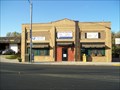
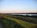
 view gallery view gallery W9.8 km W9.8 km
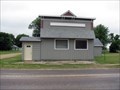
|   LITTLE MINNESOTA - 3 - Barry LITTLE MINNESOTA - 3 - Barry
in There's a Book About It This is the 3rd of the 100 cities described in the book LITTLE MINNESOTA. posted by:  jiggs11 jiggs11 location: Minnesota date approved: 04/28/2014 last visited: never |
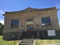
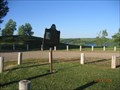
 view gallery view gallery E10.6 km E10.6 km
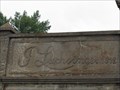
|  1912 - J. Luchsinger Store - Johnson, MN 1912 - J. Luchsinger Store - Johnson, MN
in Dated Buildings and Cornerstones In 2010, the J. Luchsinger Store on Main Street in Johnson, MN was an abandoned relic of the past. Johnson MN is the 42nd of 100 of the cities described in the book LITTLE MINNESOTA. posted by: Benchmark Blasterz location: Minnesota date approved: 07/11/2017 last visited: 07/15/2017 |
 view gallery view gallery S15.9 km S15.9 km
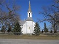
|  St. Pauli Lutheran Church - MN St. Pauli Lutheran Church - MN
in Country Churches Located on hiway 75 south of Clinton MN. posted by: MNSearchers location: Minnesota date approved: 04/17/2007 last visited: 04/17/2007 |
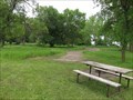 view gallery view galleryS21.9 km |  Meadowbrook Area Campground - Ortonville, Minn. Meadowbrook Area Campground - Ortonville, Minn.
in Campgrounds Tent and RV camping at Big Stone Lake State Park. posted by: msrubble location: Minnesota date approved: 06/18/2020 last visited: 05/17/2021 |
  SW23.7 km SW23.7 km
|  Big Stone Lake Big Stone Lake
in Fishing Holes You will find this fishing hole in front of cramers resort. Great spot for fishing walleyes in the spring and summer. Fall is a great time of year to fish pearch at this location. posted by:  Milbank Milbank location: South Dakota date approved: 10/02/2005 last visited: 05/17/2021 |
 view gallery view gallery SE25.7 km SE25.7 km
| Eidskog Lutheran Church - MN in Country Churches Location Address:
5 Mi N 7 Mi E
Ortonville, MN 56278 posted by: MNSearchers location: Minnesota date approved: 06/08/2006 last visited: 07/02/2007 |
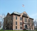 view gallery view galleryS29.5 km |  Big Stone County Courthouse , Ortonville, MN Big Stone County Courthouse , Ortonville, MN
in U.S. National Register of Historic Places This brick and stone courthouse was constructed in 1902. posted by:  NevaP NevaP location: Minnesota date approved: 05/26/2008 last visited: 05/17/2021 |
 view gallery view galleryS29.5 km |  Big Stone County Courthouse, Ortonville, MN Big Stone County Courthouse, Ortonville, MN
in Courthouses This brick and stone courthouse was constructed in 1902. posted by: NevaP location: Minnesota date approved: 05/26/2008 last visited: 05/17/2021 |
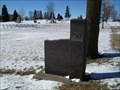 view gallery view galleryS29.6 km |  Greenwood Cemetery, Big Stone City, South Dakota Greenwood Cemetery, Big Stone City, South Dakota
in Worldwide Cemeteries Small town cemetery on the South Dakota/Minnesota border. Elevation 1094 posted by: NGComets location: South Dakota date approved: 05/30/2020 last visited: never |
 view gallery view galleryW30.1 km |  Browns Valley Man Browns Valley Man
in Minnesota Historical Markers In 1933 an amateur archeologist (William Jensen) found the bones of a skeleton buried in a gravel pit. posted by: MNSearchers location: Minnesota date approved: 06/01/2006 last visited: 09/20/2022 |
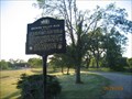
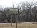
 view gallery view galleryS30.3 km | Geology of Minnesota Ortonville Region in Minnesota Historical Markers Big Stone Lake - Headwaters of the Minnesota River posted by: MNSearchers location: Minnesota date approved: 06/01/2006 last visited: 05/17/2021 |
 view gallery view galleryS31.1 km |  Big Stone City, South Dakota 57216 Big Stone City, South Dakota 57216
in U.S. Post Offices Small town post office. posted by: NGComets location: South Dakota date approved: 10/04/2010 last visited: never |
 view gallery view galleryW31.1 km |  Browns Valley Carnegie Library - Browns Valley, MN Browns Valley Carnegie Library - Browns Valley, MN
in Carnegie Library Buildings This former Carnegie Library stands at the intersection of Broadway and 2nd street. posted by: m&m O location: Minnesota date approved: 07/28/2020 last visited: never |
 view gallery view galleryW31.2 km | Browns Valley, Minnesota 56219 in U.S. Post Offices Small town post office. posted by: NGComets location: Minnesota date approved: 07/19/2012 last visited: 06/12/2017 |
 view gallery view gallerySW31.4 km |  You are entering Roberts County South Dakota You are entering Roberts County South Dakota
in South Dakota Historical Markers This marker is on the south side of Robert County. posted by: Milbank location: South Dakota date approved: 03/15/2006 last visited: never |
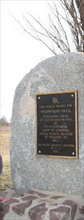 view gallery view galleryW31.7 km | Wadsworth Trail in Minnesota Historical Markers An original pioneer trail blazed in 1864 extending from St. Cloud to Ft. Sisseton (Ft. Wadsworth) South Dakota. posted by: GPX Navigators location: Minnesota date approved: 07/04/2006 last visited: 06/12/2017 |
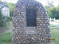
 view gallery view galleryW31.9 km | Sam Brown Log House in Minnesota Historical Markers The city of Browns Valley was founded in 1866 by Major Joseph R. Brown, who owned about 1,000 acres of land in the valley. posted by: MNSearchers location: Minnesota date approved: 06/01/2006 last visited: 06/01/2006 |
 view gallery view galleryW31.9 km | Samuel Jerome Brown in Minnesota Historical Markers Sam Brown the "Paul Revere of the Frontier". posted by: MNSearchers location: Minnesota date approved: 06/01/2006 last visited: 06/01/2006 |
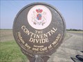
 view gallery view galleryW32.5 km | Continental Divide in Minnesota Historical Markers Today the Minnesota River travels a path that was chartered as the result of glacial movements thousands of years ago. posted by: GPX Navigators location: Minnesota date approved: 07/04/2006 last visited: 06/12/2017 |
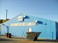 view gallery view galleryS32.5 km |  "American Legion Post 229" Big Stone City, South Dakota "American Legion Post 229" Big Stone City, South Dakota
in Legion Posts and Branches American Legion Post named for John F. Gertje, killed on October 4, 1918, and John Van Lith, killed in action during the Tunisian Campaign, North Africa. posted by: NGComets location: South Dakota date approved: 11/17/2010 last visited: never |
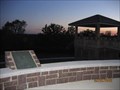
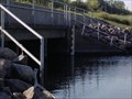 view gallery view galleryW33.3 km |  Gauge at the continental divide, Lake Travese, South Dakota Gauge at the continental divide, Lake Travese, South Dakota
in River Gauges A gauge that is at the bridge between the water that flows to the Hudson Bay and the Gulf of Mexico. posted by: BarbershopDru location: South Dakota date approved: 09/05/2007 last visited: 06/12/2017 |
 view gallery view galleryW33.3 km | Continental Divide, Sisseton, South Dakota in South Dakota Historical Markers A Continental Divide sign near Siseton, South Dakota. posted by: BarbershopDru location: South Dakota date approved: 09/19/2007 last visited: 01/05/2014 |
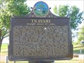 view gallery view galleryW33.8 km | Travare in South Dakota Historical Markers The dream of every townsite company was to be the county seat town. posted by: MNSearchers location: South Dakota date approved: 05/31/2006 last visited: 07/18/2014 |
 view gallery view galleryW33.8 km | Ancient River Warren Channel in South Dakota Historical Markers Ancient River Warren Channel as been designated a registered natural landmark. posted by: MNSearchers location: South Dakota date approved: 05/31/2006 last visited: 06/12/2017 |
 view gallery view galleryW33.8 km | Burial Mounds in South Dakota Historical Markers Eastern South Dakota has many burial mounds. posted by: MNSearchers location: South Dakota date approved: 05/31/2006 last visited: 02/04/2007 |
|