 view gallery view gallery SW3.2 km SW3.2 km
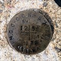
|   NCC BM 1252 - Constance Bay, ON NCC BM 1252 - Constance Bay, ON
in Canadian Benchmarks For public access, use the signed entrances to the beach. Then follow the beach to the navigation light. posted by:  elyob elyob location: Ontario, Canada date approved: 07/02/2022 last visited: never |
 view gallery view gallery S4 km S4 km
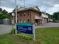
|  Fire Station #63 Fire Station #63
in Firehouses Located in Constance Bay, the station is northwest of the intersection of Bayview Drive and Bishop Davis Drive. posted by: elyob location: Ontario, Canada date approved: 07/31/2022 last visited: never |
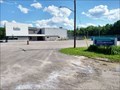 view gallery view gallerySW4.3 km |  NorthWind Wireless Community Centre, Constance Bay, Ontario NorthWind Wireless Community Centre, Constance Bay, Ontario
in Municipal Community Centers The large sign is at the posted co-ordinates. posted by: elyob location: Ontario, Canada date approved: 08/07/2022 last visited: never |
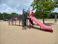 view gallery view gallerySW4.3 km |  Community Centre Playground, Constance Bay, Ontario Community Centre Playground, Constance Bay, Ontario
in Public Playgrounds 262 Len Purcell Drive posted by: elyob location: Ontario, Canada date approved: 07/24/2022 last visited: 07/29/2022 |
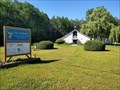 view gallery view galleryS4.7 km |  St. Gabriel's Roman Catholic Church - Constance Bay, Ontario St. Gabriel's Roman Catholic Church - Constance Bay, Ontario
in Roman Catholic Churches The church is on the west side of Bayview Drive, north of Hunter Crescent. posted by: elyob location: Ontario, Canada date approved: 08/14/2022 last visited: never |
 view gallery view galleryS5.6 km |  Constance Bay Little Free Library (#139428) - Constance Bay, Ontario Constance Bay Little Free Library (#139428) - Constance Bay, Ontario
in Free Community Book Exchanges Head south on Baillie Avenue which is near the bend of Constance Bay Road and Bayview Drive. posted by: elyob location: Ontario, Canada date approved: 08/21/2022 last visited: never |
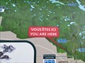
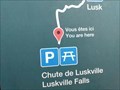 view gallery view gallery E5.6 km E5.6 km
|  You Are Here - Lusk Falls Trail , Gatineau, Quebec You Are Here - Lusk Falls Trail , Gatineau, Quebec
in 'You Are Here' Maps At parking for the Lusk Falls trail. posted by: The Burrow location: Québec, Canada date approved: 09/16/2020 last visited: never |
 view gallery view galleryE5.6 km | You Are Here - Eardley Escarpment , Gatineau, Quebec in 'You Are Here' Maps At parking for the Eardley Escarpment. posted by: The Burrow location: Québec, Canada date approved: 09/16/2020 last visited: never |
 view gallery view galleryE5.8 km |  Luskville Falls ////////// Luskville Falls //////////
in Waterfalls This Gatineau Park waterfall trail is best visited in early Spring and perhaps again in the fall of the year to capture the Autumn colours! posted by: JohnMc location: Québec, Canada date approved: 03/26/2006 last visited: 12/20/2020 |
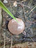 view gallery view galleryS6.8 km | 68U014 - Woodlawn, ON in Canadian Benchmarks This can be a dangerous intersection. posted by: elyob location: Ontario, Canada date approved: 07/21/2022 last visited: never |
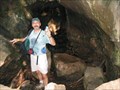 view gallery view gallery NE8.7 km NE8.7 km
| ") Lusk Cave, Gatineau Park, Gatineau, Quebec Lusk Cave, Gatineau Park, Gatineau, Quebec
in Cave Entrances (Natural) A 12,500 year old cave, unusual in that it transects a hill! posted by: bluelamb03 location: Québec, Canada date approved: 05/12/2011 last visited: 11/17/2019 |
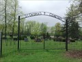
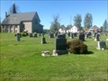 view gallery view galleryS9 km |  St Thomas Anglican Cemetery, Woodlawn, Torbolton Township, Carleton County, Ontario St Thomas Anglican Cemetery, Woodlawn, Torbolton Township, Carleton County, Ontario
in Worldwide Cemeteries St Thomas Anglican Church is located southeast of the intersection of Kinburn Side Road and Woodkilton Road; lot 10, concession III, Torbolton township. posted by: elyob location: Ontario, Canada date approved: 11/13/2015 last visited: never |
 view gallery view galleryS10.1 km | 68U011 in Canadian Benchmarks on the south side of Vances Sideroad, east of Dunrobin Road posted by: elyob location: Ontario, Canada date approved: 10/07/2018 last visited: never |
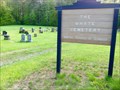
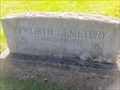 view gallery view galleryS11.1 km | Epworth Cemetery, Fitzroy Township, Carleton County, Ontario in Worldwide Cemeteries The cemetery is located northwest of the intersection of Stonecrest Road and Sol Lane; lot 12, concession 12, Fitzroy township. posted by: elyob location: Ontario, Canada date approved: 11/13/2015 last visited: never |
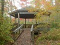 view gallery view galleryS11.3 km |  Ken Cox Field Centre - Dunrobin, Ontario Ken Cox Field Centre - Dunrobin, Ontario
in Gazebos The Bill Mason Centre is beside the West Carleton Secondary School. posted by: elyob location: Ontario, Canada date approved: 10/05/2018 last visited: 04/17/2010 |
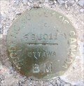
 view gallery view gallery SE12.2 km SE12.2 km
| NCC BM 1051 in Canadian Benchmarks The marker is on the north side of Thomas A Dolan Parkway. posted by: elyob location: Ontario, Canada date approved: 05/21/2017 last visited: never |
 view gallery view gallerySW12.7 km | St George's Anglican Cemetery, Fitzroy Township, Ontario in Worldwide Cemeteries The entrance to the cemetery lane is on Fitzroy Street (N 45° 28.626 W 076° 12.353). posted by: elyob location: Ontario, Canada date approved: 05/26/2017 last visited: never |
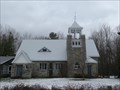 view gallery view gallerySE12.7 km |  St. Mary's Anglican Church - Ottawa, Ontario St. Mary's Anglican Church - Ottawa, Ontario
in Ontario Heritage Properties St. Mary's Anglican Church, erected in 1909, is located on Sixth line road, in the community of Dunrobin, in the City of Ottawa. posted by: Weathervane location: Ontario, Canada date approved: 11/27/2022 last visited: never |
 view gallery view gallerySE12.7 km | St. Mary's Anglican Church - Ottawa, Ontario in This Old Church St. Mary's Anglican Church, located in the community of Dunrobin, in the City of Ottawa, Ontario, was erected in 1909. posted by: Weathervane location: Ontario, Canada date approved: 11/27/2022 last visited: never |
 view gallery view gallerySE12.7 km | Old St. Mary's Anglican Church - Pinhey Point, Ottawa, Ontario in Ontario Heritage Properties The Old St. Mary's Anglican Church, constructed between 1825 and 1827, is located on the Hamnett Kirkes Estate Historic site at Pinhey Point, in Ottawa, Ontario. posted by: Weathervane location: Ontario, Canada date approved: 11/26/2022 last visited: never |
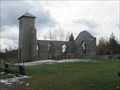 view gallery view gallerySE12.7 km |  Old St. Mary's Anglican Church - Pinhey Point - Ottawa, Ontario Old St. Mary's Anglican Church - Pinhey Point - Ottawa, Ontario
in Preserved Architectural Remnants and Ruins Old St. Mary's Anglican Church was constructed between 1825 and 1827 in rural March Township. The building was largely financed by landowner Hamnett Kirkes Pinhey, a retired London merchant turned landed gentleman. posted by: Weathervane location: Ontario, Canada date approved: 11/26/2022 last visited: never |
 view gallery view gallery W12.7 km W12.7 km
| Whyte Cemetery, Fitzroy Township, Ontario in Worldwide Cemeteries The address is 5401 Canon Smith Road. posted by: elyob location: Ontario, Canada date approved: 05/26/2017 last visited: never |
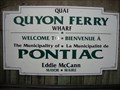 view gallery view galleryW12.9 km |  Quyon Ferry - Quyon, Quebec Quyon Ferry - Quyon, Quebec
in Ferries and Ferry Landings The Quyon Ferry provides and important inter-provincial link and is relied upon by the agriculture, tourism and service industries in the Ottawa Valley and the Outaouais regions. posted by: model12 location: Québec, Canada date approved: 09/06/2010 last visited: 07/03/2017 |
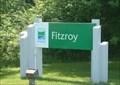 view gallery view gallerySW12.9 km |  Fitzroy Provincial Park - Ottawa ON Fitzroy Provincial Park - Ottawa ON
in Campgrounds Provincial Park close to Ottawa with seasonal camping posted by: oreillypatton location: Ontario, Canada date approved: 06/07/2022 last visited: 07/31/2022 |
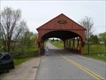 view gallery view gallery N12.9 km N12.9 km
|  1958 Covered Bridge - Gatineau Park, QC 1958 Covered Bridge - Gatineau Park, QC
in Covered Bridges A red painted wooden covered bridge crossing the La Peche River just outside the east entrance to Gatineau Park. posted by: model12 location: Québec, Canada date approved: 05/19/2011 last visited: 11/17/2019 |
|