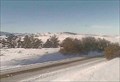
 view gallery view gallery SE26.9 km SE26.9 km
|   Roscoe Hill Northwest Web camera - Roscoe, MT Roscoe Hill Northwest Web camera - Roscoe, MT
in Web Cameras This is one of 73 (as of February 2017) Road Weather Information System camera sites operated by the Montana Department of Transportation to aid motorists as they make their way across BIG SKY Country. posted by:  T0SHEA T0SHEA location: Montana date approved: 02/09/2017 last visited: never |
 view gallery view gallerySE26.9 km | Roscoe Hill Roadway Web camera - Roscoe, MT in Web Cameras This is one of 73 (as of February 2017) Road Weather Information System camera sites operated by the Montana Department of Transportation to aid motorists as they make their way across BIG SKY Country. posted by: T0SHEA location: Montana date approved: 02/09/2017 last visited: never |
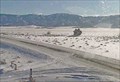 view gallery view gallerySE26.9 km | Roscoe Hill Southeast Web camera - Roscoe, MT in Web Cameras This is one of 73 (as of February 2017) Road Weather Information System camera sites operated by the Montana Department of Transportation to aid motorists as they make their way across BIG SKY Country. posted by: T0SHEA location: Montana date approved: 02/09/2017 last visited: never |
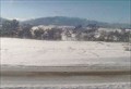
 view gallery view gallery E28.2 km E28.2 km
|  Monument Is Erected to Memory of J.E. Madson, Formerly of Butte Monument Is Erected to Memory of J.E. Madson, Formerly of Butte
in News Article Locations On the east side of Highway 78/289 at a small pullout, this granite monument is a short four miles south of Absarokee and a long eight miles north of the Roscoe turnoff. posted by: T0SHEA location: Montana date approved: 08/03/2017 last visited: never |
 view gallery view galleryE28.2 km |  The Bozeman Trail - Absarokee, MT The Bozeman Trail - Absarokee, MT
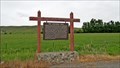
in Roadside Attractions On the east side of Highway 78/289 at a small pullout, this Montana Historical Highway Marker is a short four miles south of Absarokee and a long eight miles north of the Roscoe turnoff. posted by: T0SHEA location: Montana date approved: 04/26/2019 last visited: never |
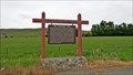 view gallery view galleryE28.2 km |  The Bozeman Trail - Absarokee, MT The Bozeman Trail - Absarokee, MT
in Montana Historical Markers On the east side of Highway 78/289 at a small pullout, this Montana Historical Highway Marker is a short four miles south of Absarokee and a long eight miles north of the Roscoe turnoff. posted by: T0SHEA location: Montana date approved: 08/06/2017 last visited: never |
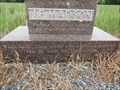
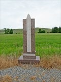 view gallery view galleryE28.2 km |  Reverend J.E. Madson - Absarokee, MT Reverend J.E. Madson - Absarokee, MT
in Citizen Memorials On the east side of Highway 78/289 at a small pullout, this granite monument is a short four miles south of Absarokee and a long eight miles north of the Roscoe turnoff. posted by: T0SHEA location: Montana date approved: 04/21/2019 last visited: never |
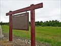 view gallery view galleryE28.5 km | The Rosebud Agency - Absarokee, MT in Montana Historical Markers On the west side of Highway 78/289 at a small pullout, this Montana Historical Highway Marker is about 2.5 miles south of Absarokee, at the site of the Rosebud Agency. posted by: T0SHEA location: Montana date approved: 08/06/2017 last visited: never |
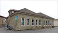
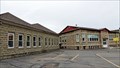 view gallery view galleryE29.8 km |  Sandstone and Cobblestone Schools - Absarokee, MT Sandstone and Cobblestone Schools - Absarokee, MT
in Wikipedia Entries Designed by an engineer and built of local materials by volunteers, Absarokee's old Cobblestone School served as the town's high school until its closing in 1990. It was preceded by the Sandstone School, built in 1910. posted by: T0SHEA location: Montana date approved: 02/14/2022 last visited: never |
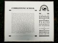
 view gallery view galleryE29.8 km |  Sandstone and Cobblestone Schools - Absarokee, MT Sandstone and Cobblestone Schools - Absarokee, MT
in U.S. National Register of Historic Places Designed by an engineer and built of local materials by volunteers, Absarokee's old Cobblestone School served as the town's high school until its closing in 1990. It was preceded by the Sandstone School, built in 1910. posted by: T0SHEA location: Montana date approved: 07/22/2017 last visited: never |
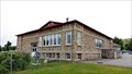 view gallery view galleryE29.8 km |  Former Cobblestone High School - Absarokee, MT Former Cobblestone High School - Absarokee, MT
in Former Schools Designed by an engineer and built of local materials by volunteers, Absarokee's old Cobblestone School served as the town's high school until its closing in 1990. posted by: T0SHEA location: Montana date approved: 07/22/2017 last visited: never |
 view gallery view galleryE29.8 km | Cobblestone School - Absarokee, MT in Montana Historical Markers Designed by an engineer and built of local materials by volunteers, Absarokee's old Cobblestone School served as the town's high school until its closing in 1990. It was preceded by the Sandstone School, built in 1910. posted by: T0SHEA location: Montana date approved: 07/27/2017 last visited: never |
 view gallery view galleryE29.8 km |  Cobblestone School - Absarokee, MT Cobblestone School - Absarokee, MT
in Cobblestone Buildings Designed by an engineer and built of local materials by volunteers, Absarokee's old Cobblestone School served as the town's high school until its closing in 1990. posted by: T0SHEA location: Montana date approved: 07/23/2017 last visited: never |
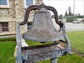 view gallery view galleryE29.8 km |  Absarokee School Bell - Absarokee, MT Absarokee School Bell - Absarokee, MT
in Bells Absarokee's old Cobblestone School served as the town's high school until its closing in 1990. It was preceded by the Sandstone School, built in 1910. In front of the Cobblestone School is this bell, origin uncertain. posted by: T0SHEA location: Montana date approved: 07/23/2017 last visited: never |
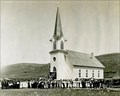 view gallery view galleryE29.8 km |  Immanuel Lutheran Church - Absarokee, MT Immanuel Lutheran Church - Absarokee, MT
in Photos Then and Now The congregation of Immanuel Lutheran, the third Lutheran church in Montana,and the first south of the Yellowstone River, was officially formed on February 16, 1897. posted by: T0SHEA location: Montana date approved: 02/01/2018 last visited: never |
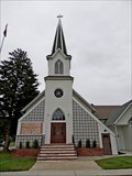 view gallery view galleryE29.8 km |  Immanuel Lutheran Church - Absarokee, MT Immanuel Lutheran Church - Absarokee, MT
in Unique Steeples The congregation of Immanuel Lutheran, the third Lutheran church in Montana,and the first south of the Yellowstone River, was officially formed on February 16, 1897. posted by: T0SHEA location: Montana date approved: 01/31/2018 last visited: never |
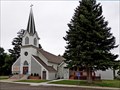 view gallery view galleryE29.8 km |  Immanuel Lutheran Church - Absarokee, MT Immanuel Lutheran Church - Absarokee, MT
in Lutheran Churches The congregation of Immanuel Lutheran, the third Lutheran church in Montana,and the first south of the Yellowstone River, was officially formed on February 16, 1897. posted by: T0SHEA location: Montana date approved: 02/02/2018 last visited: never |
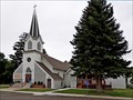
 view gallery view galleryE29.8 km |  1916 - Immanuel Lutheran Church - Absarokee, MT 1916 - Immanuel Lutheran Church - Absarokee, MT
in Dated Buildings and Cornerstones The congregation of Immanuel Lutheran, the third Lutheran church in Montana,and the first south of the Yellowstone River, was officially formed on February 16, 1897. posted by: T0SHEA location: Montana date approved: 01/31/2018 last visited: never |
 view gallery view galleryE29.8 km | Immanuel Lutheran Church - Absarokee, MT in This Old Church The congregation of Immanuel Lutheran, the third Lutheran church in Montana, and the first south of the Yellowstone River, was officially formed on February 16, 1897. posted by: T0SHEA location: Montana date approved: 01/31/2018 last visited: never |
 view gallery view galleryE29.8 km |  Immanuel Lutheran Church - Absarokee, MT Immanuel Lutheran Church - Absarokee, MT
in Bell Towers The congregation of Immanuel Lutheran, the third Lutheran church in Montana,and the first south of the Yellowstone River, was officially formed on February 16, 1897. posted by: T0SHEA location: Montana date approved: 01/31/2018 last visited: never |
 view gallery view galleryE29.8 km | Former Sandstone School - Absarokee, MT in Former Schools Built in 1910, the Sandstone School was the first of two schools to be built here side by side. It served as a grade school until, along with its companion, being replaced by a newer and larger school building in 1990. posted by: T0SHEA location: Montana date approved: 07/22/2017 last visited: never |
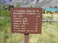 view gallery view gallerySE29.8 km |  East Rosebud Trail - Montana East Rosebud Trail - Montana
in Long Distance Hiking Trails A 26 mile route traversing the Custer National Forest, Gallatin National Forest and the Absaroka - Beartooth Wilderness posted by:  CM-14 CM-14 location: Montana date approved: 07/23/2007 last visited: never |
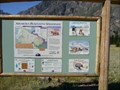 view gallery view gallerySE29.8 km |  "You Are Here" Map @ Absaroka-Beartooth Wilderness, East Rosebud Trailhead - Montana "You Are Here" Map @ Absaroka-Beartooth Wilderness, East Rosebud Trailhead - Montana
in 'You Are Here' Maps Map located at the northern trailhead of the East Rosebud Trail. posted by: CM-14 location: Montana date approved: 07/21/2007 last visited: 01/01/2021 |
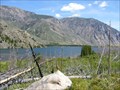 view gallery view gallerySE29.8 km |  East Rosebud Lake - Montana East Rosebud Lake - Montana
in Fishing Holes Located on the East Rosebud Trail, excellent trout fishing. posted by: CM-14 location: Montana date approved: 07/21/2007 last visited: never |
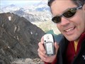 view gallery view gallery S30.3 km S30.3 km
|  Granite Peak, Montana's High Point Granite Peak, Montana's High Point
in Mountain Summits One of the 50 United States High Points. posted by: The Mercury Project location: Montana date approved: 09/07/2005 last visited: never |
|