 view gallery view gallery NE14.8 km NE14.8 km
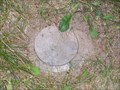
|   QM0551 (A227) Vertical Control Mark QM0551 (A227) Vertical Control Mark
in U.S. Benchmarks A227 Vertical Control Mark next to Laona School Forest Historical Marker. posted by:  frankhj frankhj location: Wisconsin date approved: 08/14/2007 last visited: 04/30/2013 |
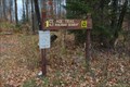
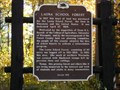 view gallery view galleryNE14.8 km |  Laona School Forest Laona School Forest
in Wisconsin Historical Markers Loaona School Forest Marker S. of Laona. posted by: frankhj location: Wisconsin date approved: 08/13/2007 last visited: 04/30/2013 |
 view gallery view gallery SW15 km SW15 km
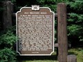
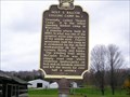
| Old Military Road in Wisconsin Historical Markers Old Military Road Marker N. of Lily. posted by: frankhj location: Wisconsin date approved: 07/22/2007 last visited: 09/26/2014 |
 view gallery view gallery N16.4 km N16.4 km
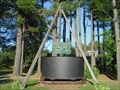
|  Soup Kettle Soup Kettle
in Ginormous Everyday Objects Worlds largest soup kettle in Laona, WI. posted by: tiki-4 location: Wisconsin date approved: 10/15/2005 last visited: 04/30/2013 |
 view gallery view galleryN17.1 km | QM0543 (X226) Vertical Control Mark in U.S. Benchmarks X226 Vertical Control Mark next to Northern Highland Historical Marker. posted by: frankhj location: Wisconsin date approved: 08/10/2007 last visited: 04/30/2013 |
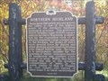 view gallery view galleryN17.1 km | Northern Highland in Wisconsin Historical Markers Northern Highland Marker E. of Crandon. posted by: frankhj location: Wisconsin date approved: 08/13/2007 last visited: 07/22/2017 |
 view gallery view gallery W18.5 km W18.5 km
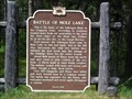
| Battle of Mole Lake in Wisconsin Historical Markers Battle of Mole Lake Marker in Mole Lake. posted by: frankhj location: Wisconsin date approved: 07/22/2007 last visited: 09/12/2009 |
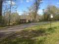
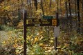 view gallery view gallerySW20.4 km |  Ice Age Trail - Langlade County Ice Age Trail - Langlade County
in Ice Age Trail Trailhead sign for the Kettlebowl Segment posted by: The Troops location: Wisconsin date approved: 10/14/2012 last visited: 05/18/2017 |
 view gallery view gallery SE24.5 km SE24.5 km
| Holt & Balcom Logging Camp No. 1 in Wisconsin Historical Markers Holt & Balcom Logging Camp No. 1 Marker on the grounds of McCauslin Brook Golf Course in Lakewood. posted by: frankhj location: Wisconsin date approved: 08/13/2007 last visited: never |
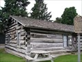 view gallery view gallerySE24.5 km |  Holt and Balcom Logging Camp No. 1 - Lakewood, WI Holt and Balcom Logging Camp No. 1 - Lakewood, WI
in U.S. National Register of Historic Places Holt and Balcom Logging Camp No. 1 on grounds of McCauslin Brook Golf Course in Lakewood. posted by: frankhj location: Wisconsin date approved: 08/11/2007 last visited: never |
 view gallery view gallery S26.2 km S26.2 km
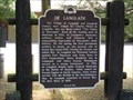
| De Langlade in Wisconsin Historical Markers De Langlade Marker in Langlade. posted by: frankhj location: Wisconsin date approved: 08/13/2007 last visited: 01/30/2022 |
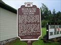 view gallery view galleryW26.6 km | Mecikalski Stovewood Building in Wisconsin Historical Markers Mecikalski Stovewood Building Marker at the Junction of CR-B and CR-Z, Pelican Lake, Oneida County posted by: frankhj location: Wisconsin date approved: 07/08/2013 last visited: never |
 view gallery view gallerySW26.9 km | Ice Age Trail - Langlade County in Ice Age Trail Old Railroad Segment of the Ice Age Trail posted by: The Troops location: Wisconsin date approved: 10/14/2012 last visited: never |
 view gallery view gallery NW29.5 km NW29.5 km
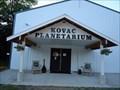
|  Kovac Planetarium - Rhinelander, WI Kovac Planetarium - Rhinelander, WI
in Planetariums The Kovac Planetarium is the worlds largest mechanical globe planetarium. A visit offers the opportunity for a brief tour and a very educational session on our universe. posted by: BlueSnowOwl location: Wisconsin date approved: 05/05/2012 last visited: never |
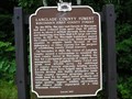 view gallery view galleryW29.6 km | Langlade County Forest - Wisconsin's First County Forest in Wisconsin Historical Markers Langlade County Forest Marker in Veteran's Memorial Park, Deerbrook. Park entrance is at N45°19.889' W089°06.461', corner of CR-J and Pence Lake Rd, E. of 45, N. of Antigo. posted by: frankhj location: Wisconsin date approved: 08/24/2007 last visited: 09/26/2014 |
 view gallery view gallerySW41.4 km | Antigo Silt Loam State Soil of Wisconsin in Wisconsin Historical Markers Antigo Silt Loam State Soil of Wisconsin Historical Marker in wayside on Hwy 52 just south of Hwy 64. posted by:  onfire4jesus onfire4jesus location: Wisconsin date approved: 04/16/2007 last visited: 04/16/2007 |
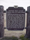 view gallery view gallerySW41.4 km |  Antigo Silt Loam State Soil of Wisconsin Antigo Silt Loam State Soil of Wisconsin
in Places of Geologic Significance Antigo silt loam, first identified through a resource inventory conducted in Langlade County in 1933, was named after the nearby city and occurs in areas across a dozen counties from Green Bay to Minnesota. posted by: onfire4jesus location: Wisconsin date approved: 09/27/2007 last visited: 12/24/2014 |
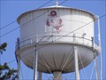 view gallery view gallerySW43.9 km |  Graham Avenue Water Tower - Antigo, WI, USA Graham Avenue Water Tower - Antigo, WI, USA
in Water Towers This is an older water tower serving the down town area of Antigo, WI. posted by: REUAHNESIE location: Wisconsin date approved: 04/27/2013 last visited: never |
 view gallery view gallerySW44.3 km |  Antigo Lake Park - Walking Trail Antigo Lake Park - Walking Trail
in Hiking and walking trailheads Antigo Lake at point of entry for walking tour. posted by: BlueSnowOwl location: Wisconsin date approved: 05/14/2012 last visited: never |
 view gallery view gallerySW44.6 km |  528 Field Street - Antigo, WI 528 Field Street - Antigo, WI
in Flatirons This building was built in the railroad hay days in Antigo, WI. posted by: REUAHNESIE location: Wisconsin date approved: 04/29/2013 last visited: never |
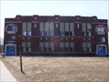 view gallery view gallerySW44.7 km |  County Normal School - Antigo, WI County Normal School - Antigo, WI
in Former Schools This was the Langlade County Teachers College built in 1922. posted by: REUAHNESIE location: Wisconsin date approved: 04/28/2013 last visited: 04/16/2016 |
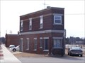
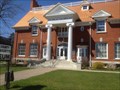 view gallery view gallerySW44.9 km |  Langlade County Historical Society / Building / Museum Langlade County Historical Society / Building / Museum
in Historical Society Headquarters The building was funded as a Carnegie Library from a grant on $14,000 originally constructed in 1905. It served as the Antigo Public Library until 1997 when the Library was moved to updated quarters- this building become the Historical Museum. posted by: BlueSnowOwl location: Wisconsin date approved: 06/13/2012 last visited: never |
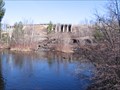 view gallery view gallery E46.3 km E46.3 km
|  High Falls Flowage - Marinette County, WI High Falls Flowage - Marinette County, WI
in Water Dams High Falls Flowage located in Central Marinette County, WI. posted by: Team B Squared location: Wisconsin date approved: 01/28/2009 last visited: never |
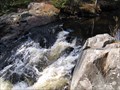 view gallery view galleryE49.9 km |  Horseshoe Falls - Marinette County, WI Horseshoe Falls - Marinette County, WI
in Waterfalls Horseshoe Falls in Marinette County, Wisconsin. posted by: Team B Squared location: Wisconsin date approved: 01/27/2009 last visited: never |
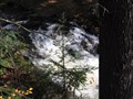 view gallery view galleryE51.7 km | Eighteenfoot Falls in Waterfalls Eighteenfoot falls located in the Marinette County Forest. posted by: Team B Squared location: Wisconsin date approved: 01/22/2009 last visited: never |
|