 view gallery view gallery SW0.2 km SW0.2 km
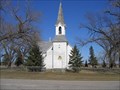
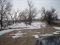
|   Eidskog Lutheran Church - MN Eidskog Lutheran Church - MN
in Country Churches Location Address:
5 Mi N 7 Mi E
Ortonville, MN 56278 posted by:  MNSearchers MNSearchers location: Minnesota date approved: 06/08/2006 last visited: 07/02/2007 |
 view gallery view gallery S11.7 km S11.7 km
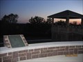
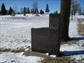
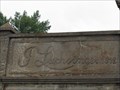
|  Odessa - Odessa, MN Odessa - Odessa, MN
in Minnesota Historical Markers A stone marker in Odessa, MN. posted by: saopaulo1 location: Minnesota date approved: 09/13/2012 last visited: never |
 view gallery view gallery NW13.5 km NW13.5 km
| St. Pauli Lutheran Church - MN in Country Churches Located on hiway 75 south of Clinton MN. posted by: MNSearchers location: Minnesota date approved: 04/17/2007 last visited: 04/17/2007 |
 view gallery view gallerySW13.5 km | Geology of Minnesota Ortonville Region in Minnesota Historical Markers Big Stone Lake - Headwaters of the Minnesota River posted by: MNSearchers location: Minnesota date approved: 06/01/2006 last visited: 05/17/2021 |
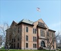 view gallery view gallerySW14 km |  Big Stone County Courthouse , Ortonville, MN Big Stone County Courthouse , Ortonville, MN
in U.S. National Register of Historic Places This brick and stone courthouse was constructed in 1902. posted by:  NevaP NevaP location: Minnesota date approved: 05/26/2008 last visited: 05/17/2021 |
 view gallery view gallerySW14 km |  Big Stone County Courthouse, Ortonville, MN Big Stone County Courthouse, Ortonville, MN
in Courthouses This brick and stone courthouse was constructed in 1902. posted by: NevaP location: Minnesota date approved: 05/26/2008 last visited: 05/17/2021 |
 view gallery view gallerySW15.9 km |  Big Stone City, South Dakota 57216 Big Stone City, South Dakota 57216
in U.S. Post Offices Small town post office. posted by: NGComets location: South Dakota date approved: 10/04/2010 last visited: never |
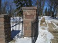
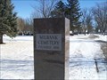
 view gallery view gallerySW16.1 km |  Greenwood Cemetery, Big Stone City, South Dakota Greenwood Cemetery, Big Stone City, South Dakota
in Worldwide Cemeteries Small town cemetery on the South Dakota/Minnesota border. Elevation 1094 posted by: NGComets location: South Dakota date approved: 05/30/2020 last visited: never |
 view gallery view gallery SE17.7 km SE17.7 km
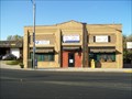
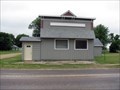
|  Farmer and Merchant State Bank - Correll, MN Farmer and Merchant State Bank - Correll, MN
in Converted Bank Buildings The former Farmer and Merchant State Bank in Correll, MN. posted by: saopaulo1 location: Minnesota date approved: 08/13/2012 last visited: 05/17/2021 |
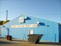 view gallery view gallerySW18.7 km |  "American Legion Post 229" Big Stone City, South Dakota "American Legion Post 229" Big Stone City, South Dakota
in Legion Posts and Branches American Legion Post named for John F. Gertje, killed on October 4, 1918, and John Van Lith, killed in action during the Tunisian Campaign, North Africa. posted by: NGComets location: South Dakota date approved: 11/17/2010 last visited: never |
 view gallery view gallery W19.6 km W19.6 km
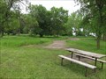
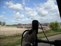
|  Meadowbrook Area Campground - Ortonville, Minn. Meadowbrook Area Campground - Ortonville, Minn.
in Campgrounds Tent and RV camping at Big Stone Lake State Park. posted by: msrubble location: Minnesota date approved: 06/18/2020 last visited: 05/17/2021 |
 view gallery view gallery N23.5 km N23.5 km
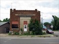
|  1912 - J. Luchsinger Store - Johnson, MN 1912 - J. Luchsinger Store - Johnson, MN
in Dated Buildings and Cornerstones In 2010, the J. Luchsinger Store on Main Street in Johnson, MN was an abandoned relic of the past. Johnson MN is the 42nd of 100 of the cities described in the book LITTLE MINNESOTA. posted by: Benchmark Blasterz location: Minnesota date approved: 07/11/2017 last visited: 07/15/2017 |
 view gallery view gallerySW24.9 km |  Dakota Granite Company Dakota Granite Company
in Active Quarries Family owned operation for over 75 years. posted by: Mountain_Wanderer location: South Dakota date approved: 01/22/2006 last visited: 05/02/2006 |
 W26.6 km |  Big Stone Lake Big Stone Lake
in Fishing Holes You will find this fishing hole in front of cramers resort. Great spot for fishing walleyes in the spring and summer. Fall is a great time of year to fish pearch at this location. posted by:  Milbank Milbank location: South Dakota date approved: 10/02/2005 last visited: 05/17/2021 |
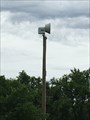 view gallery view gallerySE27.7 km |  Water Tower Outdoor Warning Siren - Appleton, MN, USA Water Tower Outdoor Warning Siren - Appleton, MN, USA
in Outdoor Warning Sirens This siren is west of the water tower near the intersection of S. Munsterman St. and Reuss Ave. posted by: m&m O location: Minnesota date approved: 06/16/2017 last visited: never |
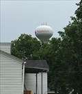 view gallery view gallerySE27.7 km |  Appleton Water Tower - Appleton, MN, USA Appleton Water Tower - Appleton, MN, USA
in Water Towers This elevated water tower is in Appleton, Minnesota and is emblazoned with the towns apple logo and name. posted by: m&m O location: Minnesota date approved: 06/16/2017 last visited: never |
 view gallery view galleryW27.7 km |  You are entering Roberts County South Dakota You are entering Roberts County South Dakota
in South Dakota Historical Markers This marker is on the south side of Robert County. posted by: Milbank location: South Dakota date approved: 03/15/2006 last visited: never |
SW29.6 km |  Super 8 Motel Milbank South Dakota Super 8 Motel Milbank South Dakota
in Wi-Fi Hotspots Can be picked up in and around the parking lot of the motel. posted by: Milbank location: South Dakota date approved: 09/08/2006 last visited: never |
 view gallery view gallerySW30.1 km | St. Lawrence Cemetery, Milbank, South Dakota in Worldwide Cemeteries A small Catholic cemetery on the north side of Milbank.
Elevation 1137 posted by: NGComets location: South Dakota date approved: 10/24/2018 last visited: never |
 view gallery view galleryNW30.6 km |  LITTLE MINNESOTA - 3 - Barry LITTLE MINNESOTA - 3 - Barry
in There's a Book About It This is the 3rd of the 100 cities described in the book LITTLE MINNESOTA. posted by: jiggs11 location: Minnesota date approved: 04/28/2014 last visited: never |
 view gallery view gallerySW30.9 km | Milbank Cemetery, Milbank, South Dakota in Worldwide Cemeteries This community cemetery is located along US Highway 12 on the east side of Milbank. Elevation 1144 posted by: NGComets location: South Dakota date approved: 10/23/2018 last visited: never |
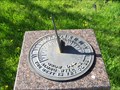 view gallery view gallerySW30.9 km |  Milbank School Sundial, Milbank, South Dakota Milbank School Sundial, Milbank, South Dakota
in Sundials Just south of the school on school property. posted by: NGComets location: South Dakota date approved: 06/04/2011 last visited: never |
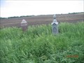 view gallery view gallerySW31.2 km |  Unnamed Alban Township Cemetery Milbank SD Unnamed Alban Township Cemetery Milbank SD
in Abandoned Cemeteries Unnamed cemetery found in Alban Township, Grant County south of Milbank SD. posted by: MNSearchers location: South Dakota date approved: 08/17/2006 last visited: 06/03/2006 |
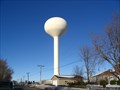 view gallery view gallerySW31.2 km | Watertower, Milbank, South Dakota in Water Towers Watertower in a small town. posted by: NGComets location: South Dakota date approved: 02/03/2009 last visited: never |
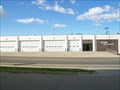 view gallery view gallerySW31.5 km |  Milbank Fire and Rescue Milbank Fire and Rescue
in Firehouses Small town fire department posted by: NGComets location: South Dakota date approved: 10/06/2010 last visited: 12/10/2017 |
|