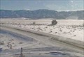
 view gallery view gallery N8.5 km N8.5 km
|   Roscoe Hill Southeast Web camera - Roscoe, MT Roscoe Hill Southeast Web camera - Roscoe, MT
in Web Cameras This is one of 73 (as of February 2017) Road Weather Information System camera sites operated by the Montana Department of Transportation to aid motorists as they make their way across BIG SKY Country. posted by:  T0SHEA T0SHEA location: Montana date approved: 02/09/2017 last visited: never |
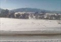 view gallery view galleryN8.5 km | Roscoe Hill Roadway Web camera - Roscoe, MT in Web Cameras This is one of 73 (as of February 2017) Road Weather Information System camera sites operated by the Montana Department of Transportation to aid motorists as they make their way across BIG SKY Country. posted by: T0SHEA location: Montana date approved: 02/09/2017 last visited: never |
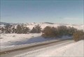 view gallery view galleryN8.7 km | Roscoe Hill Northwest Web camera - Roscoe, MT in Web Cameras This is one of 73 (as of February 2017) Road Weather Information System camera sites operated by the Montana Department of Transportation to aid motorists as they make their way across BIG SKY Country. posted by: T0SHEA location: Montana date approved: 02/09/2017 last visited: never |
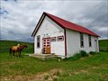
 view gallery view gallery E12.6 km E12.6 km
|  Hogan School - Red Lodge, MT Hogan School - Red Lodge, MT
in Former Schools Along Highway 78 in Carbon County, 6 or 7 miles out of Reg Lodge, the watchful may spot this little red & white schoolhouse set back from the north side side of the road. posted by: T0SHEA location: Montana date approved: 11/01/2017 last visited: never |
 view gallery view galleryE12.6 km |  Hogan School - Red Lodge, Montana USA Hogan School - Red Lodge, Montana USA
in Unoccupied Buildings, Shacks, and Cabins Along Highway 78 in Carbon County, 6 or 7 miles out of Reg Lodge, the watchful may spot this little red & white schoolhouse set back from the north side side of the road. posted by: T0SHEA location: Montana date approved: 10/30/2017 last visited: never |
 view gallery view galleryE12.6 km |  Hogan School - Red Lodge, MT Hogan School - Red Lodge, MT
in One-Room Schoolhouses Along Highway 78 in Carbon County, 6 or 7 miles out of Reg Lodge, the watchful may spot this little red & white schoolhouse set back from the north side side of the road. posted by: T0SHEA location: Montana date approved: 10/31/2017 last visited: never |
 view gallery view galleryE12.6 km |  Hogan School - 1895 - Red Lodge, MT Hogan School - 1895 - Red Lodge, MT
in Dated Architectural Structures Multifarious Along Highway 78 in Carbon County, 6 or 7 miles out of Red Lodge, the watchful may spot this little red & white schoolhouse set back from the north side side of the road. posted by: T0SHEA location: Montana date approved: 10/31/2017 last visited: never |
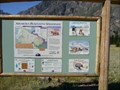 view gallery view gallery SW13.4 km SW13.4 km
|  "You Are Here" Map @ Absaroka-Beartooth Wilderness, East Rosebud Trailhead - Montana "You Are Here" Map @ Absaroka-Beartooth Wilderness, East Rosebud Trailhead - Montana
in 'You Are Here' Maps Map located at the northern trailhead of the East Rosebud Trail. posted by:  CM-14 CM-14 location: Montana date approved: 07/21/2007 last visited: 01/01/2021 |
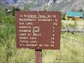 view gallery view gallerySW13.4 km |  East Rosebud Trail - Montana East Rosebud Trail - Montana
in Long Distance Hiking Trails A 26 mile route traversing the Custer National Forest, Gallatin National Forest and the Absaroka - Beartooth Wilderness posted by: CM-14 location: Montana date approved: 07/23/2007 last visited: never |
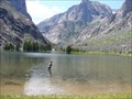
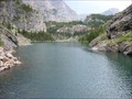
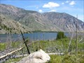 view gallery view gallerySW13.5 km |  East Rosebud Lake - Montana East Rosebud Lake - Montana
in Fishing Holes Located on the East Rosebud Trail, excellent trout fishing. posted by: CM-14 location: Montana date approved: 07/21/2007 last visited: never |
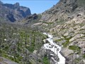 view gallery view gallerySW15.1 km |  East Rosebud Drainage - Montana East Rosebud Drainage - Montana
in Scenic Overlooks View of the East Rosebud Drainage. posted by: CM-14 location: Montana date approved: 07/21/2007 last visited: never |
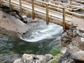
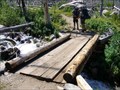 view gallery view gallerySW16.3 km |  Footbridge on the East Rosebud Trail, East Rosebud Drainage Area - Montana Footbridge on the East Rosebud Trail, East Rosebud Drainage Area - Montana
in Hiking Path Footbridges Located in the Absaroka Beartooth Wilderness. posted by: CM-14 location: Montana date approved: 08/01/2007 last visited: never |
 view gallery view gallerySW16.9 km | Elk Lake - Montana in Fishing Holes Located along the East Rosebud trail in the Custer National Forest. posted by: CM-14 location: Montana date approved: 07/22/2007 last visited: 03/23/2010 |
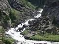 view gallery view gallerySW19.3 km |  Un-named Cascade Falls on the East Rosebud Creek - Montana Un-named Cascade Falls on the East Rosebud Creek - Montana
in Waterfalls Located along the East Rosebud Trail in the Custer National Forest. posted by: CM-14 location: Montana date approved: 07/22/2007 last visited: never |
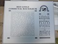
 view gallery view galleryE19.6 km |  Red Lodge Communal Mausoleum - Red Lodge, MT Red Lodge Communal Mausoleum - Red Lodge, MT
in U.S. National Register of Historic Places One of three mausoleums in the Red Lodge Cemetery, this is the only communal mausoleum, the other two being much smaller, single family units. posted by: T0SHEA location: Montana date approved: 04/30/2019 last visited: never |
 view gallery view galleryE19.6 km |  Red Lodge Communal Mausoleum - Red Lodge, MT Red Lodge Communal Mausoleum - Red Lodge, MT
in Montana Historical Markers One of three mausoleums in the Red Lodge Cemetery, this is the only communal mausoleum, the other two being much smaller, single family units. posted by: T0SHEA location: Montana date approved: 04/29/2019 last visited: never |
 view gallery view galleryE19.6 km |  Red Lodge Communal Mausoleum - Red Lodge, MT Red Lodge Communal Mausoleum - Red Lodge, MT
in Mausoleums One of three mausoleums in the Red Lodge Cemetery, this is the only communal mausoleum, the other two being much smaller, single family units. posted by: T0SHEA location: Montana date approved: 04/29/2019 last visited: never |
 view gallery view galleryE19.6 km |  Red Lodge Communal Mausoleum - Red Lodge, MT Red Lodge Communal Mausoleum - Red Lodge, MT
in Stained Glass Windows One of three mausoleums in the Red Lodge Cemetery, this is the only communal mausoleum, the other two being much smaller, single family units. posted by: T0SHEA location: Montana date approved: 02/14/2022 last visited: never |
 view gallery view galleryE19.6 km |  Red Lodge Communal Mausoleum - Red Lodge, MT Red Lodge Communal Mausoleum - Red Lodge, MT
in Wikipedia Entries One of three mausoleums in the Red Lodge Cemetery, this is the only communal mausoleum, the other two being much smaller, single family units. posted by: T0SHEA location: Montana date approved: 02/14/2022 last visited: never |
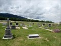 view gallery view galleryE19.6 km |  Red Lodge Cemetery - Red Lodge, Montana Red Lodge Cemetery - Red Lodge, Montana
in Worldwide Cemeteries Red Lodge Cemetery is just north of the airport on Hwy. 78. Red Lodge is about 27 km north of the Wyoming Border. posted by: T0SHEA location: Montana date approved: 01/27/2018 last visited: never |
 view gallery view gallerySW19.8 km | Rimrock Lake - Montana in Fishing Holes Located 6 miles (one way) from the parking coordinates on the East Rosebud trail in the Custer National Forest. posted by: CM-14 location: Montana date approved: 07/22/2007 last visited: never |
 view gallery view gallerySW19.8 km | Footbridge on the East Rosebud Trail @ Rimrock Lake - Montana in Hiking Path Footbridges Located in the Absaroka Beartooth Wilderness, crossing the outlet of Rimrock Lake. posted by: CM-14 location: Montana date approved: 08/05/2007 last visited: never |
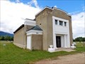
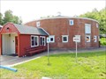 view gallery view galleryE20.1 km |  LAST - Remaining Round Brick Barn in Montana LAST - Remaining Round Brick Barn in Montana
in Last of its Kind About 1½ miles north of Red Lodge on Highway 212, this is, indeed, a round building, though now it is not really a barn, but a church hall. posted by: T0SHEA location: Montana date approved: 08/15/2017 last visited: never |
 view gallery view galleryE20.1 km | Kent Dairy Round Barn - Red Lodge, MT in Wikipedia Entries About 1½ miles north of Red Lodge on Highway 212, this is, indeed, a round building, though now it is not really a barn, but a church hall. posted by: T0SHEA location: Montana date approved: 08/15/2017 last visited: never |
 view gallery view galleryE20.1 km |  A fresh start for Historic Round Barn A fresh start for Historic Round Barn
in News Article Locations About 1½ miles north of Red Lodge on Highway 212, this is, indeed, a round building, though now it is not really a barn, but a church. posted by: T0SHEA location: Montana date approved: 08/15/2017 last visited: never |
|