 view gallery view gallery SE21.7 km SE21.7 km
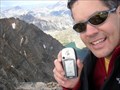
|   Granite Peak, Montana's High Point Granite Peak, Montana's High Point
in Mountain Summits One of the 50 United States High Points. posted by:  The Mercury Project The Mercury Project location: Montana date approved: 09/07/2005 last visited: never |
 view gallery view gallerySE26.2 km |  Fizzle Lake - Montana Fizzle Lake - Montana
in Fishing Holes Located in the Custer National Forest accessible via 15+ mile one-way hike on the East Rosebud Trail from the listed parking coordinates. posted by:  CM-14 CM-14 location: Montana date approved: 07/27/2007 last visited: never |
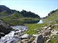
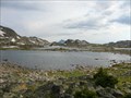
 view gallery view gallerySE26.2 km |  ORIGN: Russell Creek - Montana ORIGN: Russell Creek - Montana
in River Origins, Destinations and Confluences Fizzle Lake is the origin of Russell Creek, which decends through several lakes and traverses the Custer and Gallatin National Forests. posted by: CM-14 location: Montana date approved: 07/27/2007 last visited: never |
 view gallery view gallerySE26.9 km | Skull Lake - Montana in Fishing Holes Located in the Custer National Forest via 9 mile one-way hike up the Russell Creek Trail from the listed parking coordinates. Trout galore. posted by: CM-14 location: Montana date approved: 07/25/2007 last visited: never |
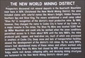 view gallery view gallery S27.4 km S27.4 km
|  The New World Mining District The New World Mining District
in Montana Historical Markers History sign about the New World Mining District. posted by: Volcanoguy location: Montana date approved: 12/17/2011 last visited: 09/21/2019 |
 view gallery view gallerySE27.4 km | Fossil Lake - Montana in Fishing Holes Located in the Custer National Forest, accessible via a 9 mile hike on the Russell Creek trail from the listed parking coordinates. posted by: CM-14 location: Montana date approved: 07/25/2007 last visited: never |
 view gallery view galleryS27.4 km |  Hoosier’s Bar - Cooke City, Montana Hoosier’s Bar - Cooke City, Montana
in Neon Signs Neon sign for Hoosier’s Bar. posted by: Volcanoguy location: Montana date approved: 12/19/2011 last visited: 09/29/2010 |
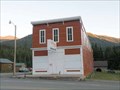 view gallery view galleryS27.4 km |  Cooke City Store - Montana Cooke City Store - Montana
in U.S. National Register of Historic Places The historic Cooke City Store building in Cooke City, Montana. posted by: Volcanoguy location: Montana date approved: 12/17/2011 last visited: 09/30/2010 |
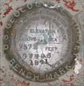 view gallery view galleryS27.4 km |  USGS GWM96, Montana USGS GWM96, Montana
in U.S. Benchmarks U.S. Geological Survey benchmark GWM96. posted by: Volcanoguy location: Montana date approved: 12/17/2011 last visited: 09/29/2010 |
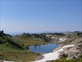
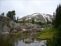
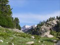 view gallery view gallerySE27.4 km |  Scenic Overlook: Mount Villard and an Un-named Lake - Montana Scenic Overlook: Mount Villard and an Un-named Lake - Montana
in Scenic Overlooks This overlook on the Russell Creek trail in the Custer National Forest provides a view of Mount Villard in one direction and an un-named Lake in the other.
posted by: CM-14 location: Montana date approved: 07/26/2007 last visited: never |
 view gallery view gallerySE27.5 km | ORIGIN: East Rosebud Creek - Montana in River Origins, Destinations and Confluences Fossil Lake sits atop the continental divide and is the origin of the East Rosebud Creek which decends through the East Rosebud Drainage. posted by: CM-14 location: Montana date approved: 07/27/2007 last visited: never |
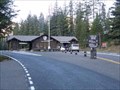 view gallery view galleryS27.5 km | Northeast Entrance Station - Yellowstone National Park, Montana in U.S. National Register of Historic Places The Northeast Entrance Station to Yellowstone National Park on U.S. Hwy. 212 just west of Silver Gate, Montana. posted by: Volcanoguy location: Montana date approved: 12/15/2011 last visited: 09/02/2019 |
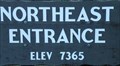
 view gallery view galleryS27.5 km |  Northeast Entrance Station, Montana Northeast Entrance Station, Montana
in Elevation Signs Elevation sign at Yellowstone’s Northeast Entrance Station. posted by: Volcanoguy location: Montana date approved: 12/25/2010 last visited: 09/02/2019 |
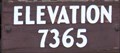
 view gallery view galleryS27.7 km | Northeast Entrance, Montana in Elevation Signs Elevation sign for Yellowstone’s Northeast Entrance. posted by: Volcanoguy location: Montana date approved: 12/25/2010 last visited: 09/02/2019 |
 view gallery view gallerySE27.8 km | Dewy Lake - Montanta in Fishing Holes Located along the East Rodebud Trail in the Absaroka Beartooth Wilderness. posted by: CM-14 location: Montana date approved: 07/29/2007 last visited: never |
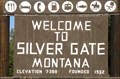 view gallery view galleryS27.8 km | Silver Gate, Montana - 7388 feet in Elevation Signs Elevation sign at west edge of community of Silver Gate, Montana. posted by: Volcanoguy location: Wyoming date approved: 12/15/2011 last visited: 09/29/2010 |
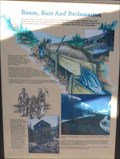 view gallery view galleryS27.8 km | Boom, Bust And Reclamation in Montana Historical Markers History sign about the Cooke City area. posted by: Volcanoguy location: Montana date approved: 12/15/2011 last visited: 09/29/2010 |
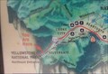 view gallery view galleryS27.8 km |  Gateways To Beartooth Country - Montana Gateways To Beartooth Country - Montana
in 'You Are Here' Maps You Are Here marker on “Gateways To Beartooth Country” sign along the U.S. Hwy. 212 just west of Silver Gate, Montana. posted by: Volcanoguy location: Montana date approved: 12/15/2011 last visited: 09/29/2010 |
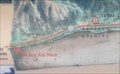 view gallery view galleryS27.8 km | Cooke City: Still Wild After All These Years - Montana in 'You Are Here' Maps You Are Here marker on “Cooke City: Still Wild After All These Years” sign along the U.S. Hwy. 212 just west of Silver Gate, Montana. posted by: Volcanoguy location: Montana date approved: 12/15/2011 last visited: 09/29/2010 |
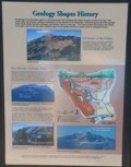 view gallery view galleryS27.8 km | Geology Shapes History in Montana Historical Markers History/geology sign about the geology of the Beartooth region. posted by: Volcanoguy location: Montana date approved: 12/15/2011 last visited: 09/29/2010 |
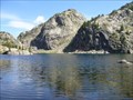 view gallery view gallerySE28 km | Un-named Lake on Russel Creek - Montana in Fishing Holes This un-name lake is located in the Custer National Forest on Russell Creek. It is accessible via an 8 mile hike on the Russell Creek trail from the listed parking coordinates. Great trout fishing. posted by: CM-14 location: Montana date approved: 07/25/2007 last visited: never |
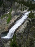
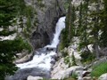 view gallery view gallerySE28.3 km |  Un-named Horsetail Falls on East Rosebud Creek - Montana Un-named Horsetail Falls on East Rosebud Creek - Montana
in Waterfalls Un-named falls that descends from Twin Outlets Lake through a narrow crevace in the bedrock. Accessible via a 10+ mile one-way hike through the Custer National Forest on the East Rosebud trail from the parking coordinates. posted by: CM-14 location: Montana date approved: 07/26/2007 last visited: never |
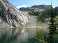 view gallery view gallerySE28.5 km | Ouzel Lake - Montana in Fishing Holes Located in the Absaroka-Beartooth Wilderness along the East Rosebud Trail. Plenty of lake trout here. posted by: CM-14 location: Montana date approved: 07/27/2007 last visited: never |
 view gallery view gallerySE28.6 km | Impasse Falls - Montana in Waterfalls Located in the Custer National Forest, Impasse Falls empties into Duggan Lake. The falls are accessible via 10+ mile one-way hike on the East Rosebud trail from the listed parking coordinates. posted by: CM-14 location: Montana date approved: 07/23/2007 last visited: 01/24/2010 |
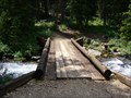 view gallery view gallerySE28.6 km |  Footbridge on the East Rosebud Trail between Big Park Lake and Duggan Lake - Montana Footbridge on the East Rosebud Trail between Big Park Lake and Duggan Lake - Montana
in Hiking Path Footbridges Located on the East Rosebud Trail. A 26 mile trail in the Absaroka Beartooth Wilderness which traverses the East Rosebud Drainage and crossed the continental divide. posted by: CM-14 location: Montana date approved: 08/07/2007 last visited: never |
|