 view gallery view gallery NW9.8 km NW9.8 km
|   East Rosebud Trail - Montana East Rosebud Trail - Montana
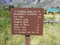
in Long Distance Hiking Trails A 26 mile route traversing the Custer National Forest, Gallatin National Forest and the Absaroka - Beartooth Wilderness posted by:  CM-14 CM-14 location: Montana date approved: 07/23/2007 last visited: never |
 view gallery view galleryNW9.8 km |  "You Are Here" Map @ Absaroka-Beartooth Wilderness, East Rosebud Trailhead - Montana "You Are Here" Map @ Absaroka-Beartooth Wilderness, East Rosebud Trailhead - Montana
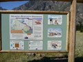
in 'You Are Here' Maps Map located at the northern trailhead of the East Rosebud Trail. posted by: CM-14 location: Montana date approved: 07/21/2007 last visited: 01/01/2021 |
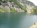
 view gallery view gallery W9.8 km W9.8 km
|  East Rosebud Drainage - Montana East Rosebud Drainage - Montana
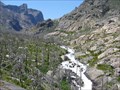
in Scenic Overlooks View of the East Rosebud Drainage. posted by: CM-14 location: Montana date approved: 07/21/2007 last visited: never |
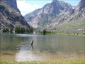
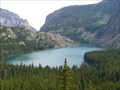
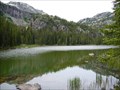
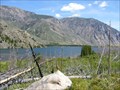 view gallery view galleryNW10 km |  East Rosebud Lake - Montana East Rosebud Lake - Montana
in Fishing Holes Located on the East Rosebud Trail, excellent trout fishing. posted by: CM-14 location: Montana date approved: 07/21/2007 last visited: never |
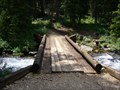
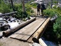 view gallery view galleryW10.1 km |  Footbridge on the East Rosebud Trail, East Rosebud Drainage Area - Montana Footbridge on the East Rosebud Trail, East Rosebud Drainage Area - Montana
in Hiking Path Footbridges Located in the Absaroka Beartooth Wilderness. posted by: CM-14 location: Montana date approved: 08/01/2007 last visited: never |
 view gallery view galleryW10.8 km | Elk Lake - Montana in Fishing Holes Located along the East Rosebud trail in the Custer National Forest. posted by: CM-14 location: Montana date approved: 07/22/2007 last visited: 03/23/2010 |
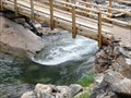
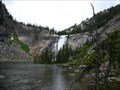
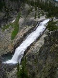
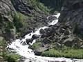 view gallery view galleryW12.7 km |  Un-named Cascade Falls on the East Rosebud Creek - Montana Un-named Cascade Falls on the East Rosebud Creek - Montana
in Waterfalls Located along the East Rosebud Trail in the Custer National Forest. posted by: CM-14 location: Montana date approved: 07/22/2007 last visited: never |
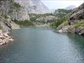 view gallery view galleryW13 km | Rimrock Lake - Montana in Fishing Holes Located 6 miles (one way) from the parking coordinates on the East Rosebud trail in the Custer National Forest. posted by: CM-14 location: Montana date approved: 07/22/2007 last visited: never |
 view gallery view galleryW13 km | Footbridge on the East Rosebud Trail @ Rimrock Lake - Montana in Hiking Path Footbridges Located in the Absaroka Beartooth Wilderness, crossing the outlet of Rimrock Lake. posted by: CM-14 location: Montana date approved: 08/05/2007 last visited: never |
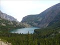
 view gallery view galleryW14.3 km | Rainbow Lake - Montana in Fishing Holes Located on the East Rosebud Trail in the Custer National Forest. A 7 mile one-way hike from the parking coordinates. posted by: CM-14 location: Montana date approved: 07/22/2007 last visited: never |
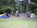 view gallery view galleryW14.3 km |  Primitive Campsite @ Rainbow Lake, East Rosebud Trail - Montana Primitive Campsite @ Rainbow Lake, East Rosebud Trail - Montana
in Campgrounds A primitive backcountry campsite located on the East Rosebud Trail in the Custer National Forest.
posted by: CM-14 location: Montana date approved: 07/22/2007 last visited: never |
 view gallery view galleryW14.3 km | Primitive Campsite @ Rainbow Lake, East Rosebud Trail - Montana in Free Campsites A primitive backcountry campsite located on the East Rosebud Trail in the Custer National Forest. posted by: CM-14 location: Montana date approved: 07/22/2007 last visited: never |
 view gallery view galleryW14.6 km | Rainbow Lake - Montana in Scenic Overlooks This overlook of Rainbow Lake is located on the East Rosebud Trail in the Custer National Forest. posted by: CM-14 location: Montana date approved: 07/23/2007 last visited: never |
 view gallery view galleryW15.1 km | Lake At Falls - Montana in Fishing Holes Located in the Custer National Forest via a 9 mile one-way hike from the listed pariking coordinates. posted by: CM-14 location: Montana date approved: 07/22/2007 last visited: never |
 view gallery view galleryW16.3 km | Big Park Lake - Montana in Fishing Holes Located in the Custer National Forest via a hike on the East Rosebud Trail. posted by: CM-14 location: Montana date approved: 07/22/2007 last visited: never |
 view gallery view galleryW17.1 km | Footbridge on the East Rosebud Trail between Big Park Lake and Duggan Lake - Montana in Hiking Path Footbridges Located on the East Rosebud Trail. A 26 mile trail in the Absaroka Beartooth Wilderness which traverses the East Rosebud Drainage and crossed the continental divide. posted by: CM-14 location: Montana date approved: 08/07/2007 last visited: never |
 view gallery view galleryW17.7 km | Duggan Lake - Montana in Fishing Holes Located in the Custer National Forest via 10+ mile one-way hike along the East Rosebud trail from the listed parking coordinates. posted by: CM-14 location: Montana date approved: 07/22/2007 last visited: never |
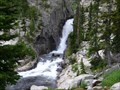
 view gallery view galleryW18 km | Impasse Falls - Montana in Waterfalls Located in the Custer National Forest, Impasse Falls empties into Duggan Lake. The falls are accessible via 10+ mile one-way hike on the East Rosebud trail from the listed parking coordinates. posted by: CM-14 location: Montana date approved: 07/23/2007 last visited: 01/24/2010 |
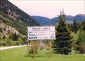 view gallery view gallery E18 km E18 km
|  Day-Reasonable and Prudent - Red Lodge MT Day-Reasonable and Prudent - Red Lodge MT
in Unusual Signs This sign is unusual in that it does not show a speed limit for the DAY- only "Reasonable and Prudent". In my travels I have never seen a speed sign without a number. posted by: Don.Morfe location: Montana date approved: 10/25/2022 last visited: 10/11/2022 |
 view gallery view galleryW18.3 km | Un-named Horsetail Falls on East Rosebud Creek - Montana in Waterfalls Un-named falls that descends from Twin Outlets Lake through a narrow crevace in the bedrock. Accessible via a 10+ mile one-way hike through the Custer National Forest on the East Rosebud trail from the parking coordinates. posted by: CM-14 location: Montana date approved: 07/26/2007 last visited: never |
 view gallery view gallery NE18.5 km NE18.5 km
|  Hogan School - Red Lodge, MT Hogan School - Red Lodge, MT
in Former Schools Along Highway 78 in Carbon County, 6 or 7 miles out of Reg Lodge, the watchful may spot this little red & white schoolhouse set back from the north side side of the road. posted by:  T0SHEA T0SHEA location: Montana date approved: 11/01/2017 last visited: never |
 view gallery view galleryNE18.5 km |  Hogan School - Red Lodge, Montana USA Hogan School - Red Lodge, Montana USA
in Unoccupied Buildings, Shacks, and Cabins Along Highway 78 in Carbon County, 6 or 7 miles out of Reg Lodge, the watchful may spot this little red & white schoolhouse set back from the north side side of the road. posted by: T0SHEA location: Montana date approved: 10/30/2017 last visited: never |
 view gallery view galleryNE18.5 km |  Hogan School - Red Lodge, MT Hogan School - Red Lodge, MT
in One-Room Schoolhouses Along Highway 78 in Carbon County, 6 or 7 miles out of Reg Lodge, the watchful may spot this little red & white schoolhouse set back from the north side side of the road. posted by: T0SHEA location: Montana date approved: 10/31/2017 last visited: never |
 view gallery view galleryNE18.5 km |  Hogan School - 1895 - Red Lodge, MT Hogan School - 1895 - Red Lodge, MT
in Dated Architectural Structures Multifarious Along Highway 78 in Carbon County, 6 or 7 miles out of Red Lodge, the watchful may spot this little red & white schoolhouse set back from the north side side of the road. posted by: T0SHEA location: Montana date approved: 10/31/2017 last visited: never |
 view gallery view gallery SE19.5 km SE19.5 km
|  Beartooth Pass - US 212 - MT/WY Beartooth Pass - US 212 - MT/WY
in Border Crossings On US 212, which the Beartooth Pass approaching Montana from Wyoming. posted by: nomadwillie location: Wyoming date approved: 04/02/2011 last visited: 08/03/2012 |
|