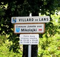
 view gallery view gallery E1.3 km E1.3 km
|   Villard-de-Lans, France - Mikolajki, Poland Villard-de-Lans, France - Mikolajki, Poland
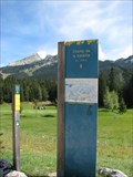
in Sister City Monuments This Sister City sign is located at the south entrance to the Commune de Villard-de-Lans on Av. des Bains (D215). posted by:  denben denben location: Auvergne-Rhône-Alpes, France date approved: 01/20/2014 last visited: 01/17/2022 |
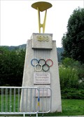 view gallery view gallery NE1.9 km NE1.9 km
|  Monument to the 1968 Winter Olympics - Villard-de-Lans, France Monument to the 1968 Winter Olympics - Villard-de-Lans, France
in Olympic Memorabilia At the 1968 Winter Olympics held in neighbouring Grenoble, Villard-de-Lans played host to the luge events. posted by: denben location: Auvergne-Rhône-Alpes, France date approved: 10/09/2013 last visited: 01/17/2022 |
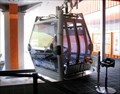 view gallery view gallery SE3.4 km SE3.4 km
|  Villard de Lans Gondola Lift - Isère, France Villard de Lans Gondola Lift - Isère, France
in Aerial Lifts This gondola lift is located at the Station Cote 2000 in Villard de Lans, Isère, Rhône-Alpes. posted by: denben location: Auvergne-Rhône-Alpes, France date approved: 01/21/2014 last visited: 01/17/2022 |
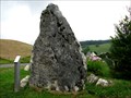 view gallery view gallery S3.5 km S3.5 km
|  Menhir du Vercors - Corrençon-en-Vercors, France Menhir du Vercors - Corrençon-en-Vercors, France
in Rock and Mineral Displays This rock is located at the entrance of the village to welcome and inform visitors that will use Corrençon-en-Vercors numerous hiking trails. posted by: denben location: Auvergne-Rhône-Alpes, France date approved: 01/05/2014 last visited: never |
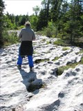
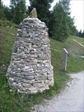 view gallery view galleryS4.8 km |  Trailhead Cairn - Corrençon-en-Vercors, Rhône-Alpes, France Trailhead Cairn - Corrençon-en-Vercors, Rhône-Alpes, France
in Cairns This cairn is located in front of the Corrençon-en-Vercors golf course buildings near the parking des Hauts-Plateaux. posted by: denben location: Auvergne-Rhône-Alpes, France date approved: 01/07/2014 last visited: 07/23/2014 |
 view gallery view galleryS4.8 km |  Golf de Corrençon - Corrençon-en-Vercors, France Golf de Corrençon - Corrençon-en-Vercors, France
in Public and Private Golf Courses Corrençon Golf Course is a 18-hole par 71 mountain golf course located in the spectacular scenery of the Vercors massif. posted by: denben location: Auvergne-Rhône-Alpes, France date approved: 02/05/2014 last visited: 07/23/2014 |
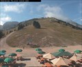 view gallery view gallerySE5 km |  Villard-de-Lans : au resto Villard-de-Lans : au resto
in Web Cameras Situé à 1720 m et accessible aux piétons et skieurs par la télécabine Cote 2000 : Restaurant self-service, bar , vue panoramique. posted by: fk_isere location: France date approved: 08/21/2009 last visited: 01/17/2022 |
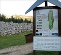
 view gallery view galleryS6 km |  Champ de Bataille - 3930 feet - Corrençon-en-Vercors, France Champ de Bataille - 3930 feet - Corrençon-en-Vercors, France
in Elevation Signs The battlefield markers are located along Corrençon golf course on the GR 91, a 40 km trail between Corrençon-en-Vercors and the Col de Rousset. posted by: denben location: Auvergne-Rhône-Alpes, France date approved: 01/09/2014 last visited: never |
 view gallery view galleryS6 km |  Le Champ de Bataille - Corrençon-en-Vercors, France Le Champ de Bataille - Corrençon-en-Vercors, France
in Battlefields The battlefield markers are located along Corrençon golf course on the GR 91, a 40 km trail between Corrençon-en-Vercors and the Col de Rousset. posted by: denben location: Auvergne-Rhône-Alpes, France date approved: 01/09/2014 last visited: never |
 view gallery view galleryS6.1 km |  Lapiaz des Hauts Plateaux du Vercors - Corrençon-en-Vercors, France Lapiaz des Hauts Plateaux du Vercors - Corrençon-en-Vercors, France
in Places of Geologic Significance The lapiaz (Limestone Pavement) along the GR 91, a 40 km trail between Corrençon-en-Vercors and the Col de Rousset, crossing the Hauts Plateaux du Vercors (French Prealps). posted by: denben location: Auvergne-Rhône-Alpes, France date approved: 02/12/2014 last visited: never |
 view gallery view gallery N6.8 km N6.8 km
|  The Vercors Aromatic and Medicinal Plants - Méaudre, France The Vercors Aromatic and Medicinal Plants - Méaudre, France
in Flora and Fauna Information Signs The informative board on aromatic and medicinal plants of the Vercors Regional Natural Park is located behind the church in Méaudre. posted by: denben location: Auvergne-Rhône-Alpes, France date approved: 02/08/2014 last visited: 07/27/2018 |
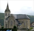
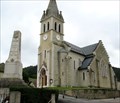 view gallery view galleryN6.8 km |  L’église de Méaudre - Méaudre, France L’église de Méaudre - Méaudre, France
in Roman Catholic Churches Built between 1883 and 1886, l’église de Méaudre is dedicated to Saint Peter and Saint Paul. It replaced the old church totally destroyed by a fire caused by lightning on Aug. 16, 1877. posted by: denben location: Auvergne-Rhône-Alpes, France date approved: 02/08/2014 last visited: 07/27/2018 |
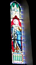 view gallery view galleryN6.8 km |  Église de Méaudre Stained Glass Windows - Méaudre, France Église de Méaudre Stained Glass Windows - Méaudre, France
in Stained Glass Windows The stained glass windows are located behind the main Altar of l'église de Méaudre in Méaudre, France posted by: denben location: Auvergne-Rhône-Alpes, France date approved: 02/08/2014 last visited: 07/27/2018 |
 view gallery view galleryN6.8 km | L’église de Méaudre - Méaudre, France in This Old Church Built between 1883 and 1886, l’église de Méaudre is dedicated to Saint Peter and Saint Paul. It replaced the old church totally destroyed by a fire caused by lightning on Aug. 16, 1877. posted by: denben location: Auvergne-Rhône-Alpes, France date approved: 02/08/2014 last visited: 07/27/2018 |
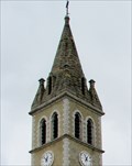 view gallery view galleryN6.8 km |  Église de Méaudre Bell Tower - Méaudre, France Église de Méaudre Bell Tower - Méaudre, France
in Bell Towers Built between 1883 and 1886, l’église de Méaudre is dedicated to Saint Peter and Saint Paul. It replaced the old church totally destroyed by a fire caused by lightning on Aug. 16, 1877. posted by: denben location: Auvergne-Rhône-Alpes, France date approved: 02/10/2014 last visited: 07/27/2018 |
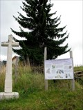
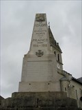 view gallery view galleryN6.8 km |  1914 - 1918 Monument aux Morts - Méaudre, France 1914 - 1918 Monument aux Morts - Méaudre, France
in World War I Memorials and Monuments The WW1 memorial is located near the church in the heart of the commune of Méaudre in France. posted by: denben location: Auvergne-Rhône-Alpes, France date approved: 02/10/2014 last visited: 07/27/2018 |
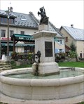 view gallery view galleryN6.8 km |  Fontaine de l'Ange au Dauphin - Méaudre, France Fontaine de l'Ange au Dauphin - Méaudre, France
in Fountains The fountain de l'Ange au Dauphin is located Place de la Mairie in Méaudre, France. posted by: denben location: Auvergne-Rhône-Alpes, France date approved: 02/08/2014 last visited: 07/27/2018 |
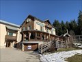 view gallery view galleryN7.6 km |  Auberge de la croix Perrin - Lans en vercors - France Auberge de la croix Perrin - Lans en vercors - France
in Lodge-Style Accommodations Bienvenue à l'Auberge de la Croix Perrin située à lans en vercors à mi-chemin entre Lans en Vercors et Autrans.
Welcome to the Auberge de la Croix Perrin located halfway between Lans en Vercors and Autrans. posted by:  Alfouine Alfouine location: Auvergne-Rhône-Alpes, France date approved: 01/11/2020 last visited: never |
 view gallery view galleryN7.6 km |  Auberge de la croix Perrin - Lans en vercors - France Auberge de la croix Perrin - Lans en vercors - France
in Ski Lodges Bienvenue à l'Auberge de la Croix Perrin située à lans en vercors à mi-chemin entre Lans en Vercors et Autrans.
Welcome to the Auberge de la Croix Perrin located halfway between Lans en Vercors and Autrans. posted by: Alfouine location: Auvergne-Rhône-Alpes, France date approved: 01/17/2020 last visited: never |
 view gallery view galleryN7.6 km |  Auberge de la croix Perrin - Lans en vercors - France Auberge de la croix Perrin - Lans en vercors - France
in Antique Hotels Bienvenue à l'Auberge de la Croix Perrin située à lans en vercors à mi-chemin entre Lans en Vercors et Autrans.
Welcome to the Auberge de la Croix Perrin located halfway between Lans en Vercors and Autrans. posted by: Alfouine location: Auvergne-Rhône-Alpes, France date approved: 01/20/2020 last visited: never |
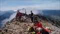 view gallery view galleryE7.6 km |  Pic Saint Michel Summit, Vercors, France Pic Saint Michel Summit, Vercors, France
in Mountain Summits Pic Saint-Michel at 1,966 m, is one of the principle summits in the Vercors area of France. posted by: arby101ca location: Auvergne-Rhône-Alpes, France date approved: 08/02/2015 last visited: 07/28/2022 |
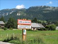 view gallery view galleryNE8 km | Lans-en-Vercors, France / Saint-Donat, Québec, Canada in Sister City Monuments This Sister City sign is located at the south entrance to the Commune de Lans-en-Vercors on the Route de Villard (D531). posted by: denben location: Auvergne-Rhône-Alpes, France date approved: 01/02/2014 last visited: 07/27/2018 |
 view gallery view gallery W10.5 km W10.5 km
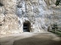
| ") Grotte de Choranche, Vercors, Isère, France Grotte de Choranche, Vercors, Isère, France
in Cave Entrances (Natural) Dans le département de l'Isère, aux portes de la Drôme, la Grotte de Choranche, nichée dans la nature exubérante du cirque de Choranche, dans le massif du Vercors, est une des plus belles grottes de France. posted by: blackjack65 location: Auvergne-Rhône-Alpes, France date approved: 08/20/2019 last visited: 08/02/2022 |
 view gallery view gallery SW11.1 km SW11.1 km
|  World War II Memorial - Les Barraques-en-Vercors, France World War II Memorial - Les Barraques-en-Vercors, France
in World War II Memorials / Monuments This World War II plaque is located on a rock wall near the entrance to the old Road des Grands Goulets in Les Barraques-en-Vercors. posted by: denben location: Auvergne-Rhône-Alpes, France date approved: 01/14/2014 last visited: 07/01/2018 |
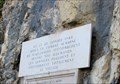
 view gallery view gallerySW11.1 km | ") Route des Grands Goulets - Les Barraques-en-Vercors, France Route des Grands Goulets - Les Barraques-en-Vercors, France
in Histoires de France (French historical markers) A commemorative plaque to the old Road des Grands Goulets is located on a rock wall near the closed entrance to the road in Les Barraques-en-Vercors. posted by: denben location: Auvergne-Rhône-Alpes, France date approved: 07/09/2020 last visited: 07/01/2018 |
|