 view gallery view gallery E12.7 km E12.7 km
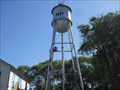
|   North Powder, OR Water Tower North Powder, OR Water Tower
in Water Towers This is the water tower for the city of North Powder, OR. The
smaller picture was snapped from the main street going thru town.
The town was incorporated in the early 1900's. posted by:  n2life n2life location: Oregon date approved: 07/10/2013 last visited: never |
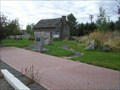
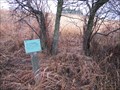
 view gallery view galleryE12.7 km |  Gazebo - North Powder, Oregon Gazebo - North Powder, Oregon
in Gazebos Town center Gazebo, meeting place, band-stand posted by: n2life location: Oregon date approved: 07/09/2013 last visited: 11/27/2020 |
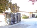
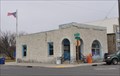 view gallery view galleryE12.9 km |  North Powder, Oregon 97867 North Powder, Oregon 97867
in U.S. Post Offices This Post Office is located at 205 E Street in North Powder, Oregon. posted by: brwhiz location: Oregon date approved: 11/10/2013 last visited: 11/27/2020 |
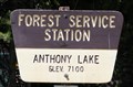 view gallery view gallery SW13.7 km SW13.7 km
|  Anthony Lake Guard Station - North Powder, OR - 7100' Anthony Lake Guard Station - North Powder, OR - 7100'
in Elevation Signs The sign is in front of the Anthony Lake Guard Station just off Forest Road 73 in the Wallowa-Whitman National Forest. posted by: WR7X location: Oregon date approved: 07/30/2016 last visited: 11/27/2020 |
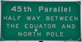 view gallery view galleryE14.3 km |  45th Parallel Sign ~ Union County, Oregon 45th Parallel Sign ~ Union County, Oregon
in Great Lines of Earth This sign marks the 45th Parallel, halfway between the Equator and the North Pole. It is just south of the junction of US Highway 30 and Interstate Highway 84 in the middle of nowhere about midway between La Grande and Baker City. posted by: brwhiz location: Oregon date approved: 03/31/2014 last visited: 11/27/2020 |
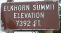 view gallery view gallerySW14.3 km | 7392 Feet, Elkhorn Summit, OR in Elevation Signs Elevation sign at Elkhorn Summit near Anthony Lakes Ski Area. posted by: Volcanoguy location: Oregon date approved: 01/03/2008 last visited: 11/27/2020 |
 view gallery view gallery SE14.6 km SE14.6 km
|  Haines Cemetery - Haines, OR Haines Cemetery - Haines, OR
in Worldwide Cemeteries Cemetery for the community of Haines, Oregon. posted by: Volcanoguy location: Oregon date approved: 01/04/2008 last visited: 11/27/2020 |
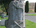 view gallery view gallerySE14.6 km |  WOW - Young - Haines, Oregon WOW - Young - Haines, Oregon
in Woodmen of the World Grave Markers/Monuments A wonderful example of Woodmen of the World grave memorial posted by: redheadsrule location: Oregon date approved: 10/13/2010 last visited: 11/27/2020 |
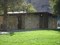
 view gallery view gallerySE17.1 km | Haines, OR, 97833 in U.S. Post Offices The Haines, OR Post Office.
posted by: Volcanoguy location: Oregon date approved: 10/15/2007 last visited: 11/27/2020 |
 view gallery view gallerySE17.2 km | Haines, OR - 3336' in Elevation Signs The sign is located on the relocated railroad depot at the Eastern Oregon Museum in Haines. posted by: WR7X location: Oregon date approved: 11/17/2019 last visited: 11/27/2020 |
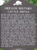 view gallery view gallerySE17.2 km |  Cattle Drives Cattle Drives
in Oregon Historical Markers Oregon History Sign about Cattle Drives at Haines, Oregon. posted by: Volcanoguy location: Oregon date approved: 10/29/2007 last visited: 11/25/2020 |
 view gallery view gallerySE17.2 km |  Dick Camp Memorial Park - Haines, OR Dick Camp Memorial Park - Haines, OR
in Municipal Parks and Plazas The Dick Camp Memorial Park is located between Hwy 30 and the railroad tracks in Haines, Oregon. posted by: Volcanoguy location: Oregon date approved: 01/05/2008 last visited: 11/27/2020 |
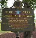 view gallery view gallery N23.7 km N23.7 km
|  Charles Reynolds Rest Area - Old Oregon Trail Highway (I-84) - La Grande, OR Charles Reynolds Rest Area - Old Oregon Trail Highway (I-84) - La Grande, OR
in Blue Star Memorial Highway Markers A Blue Star Memorial marker set in the Charles Reynolds rest area along the Old Oregon Trail Highway between Baker City and La Grande, Oregon. posted by:  The Pirate King The Pirate King location: Oregon date approved: 07/13/2011 last visited: 11/27/2020 |
 view gallery view galleryN23.7 km |  Chas. M. Reynolds Rest Area Chas. M. Reynolds Rest Area
in Highway Rest Areas Chas. M. Reynolds Rest Area posted by: Rachel83642 location: Oregon date approved: 10/16/2006 last visited: 11/27/2020 |
 view gallery view gallerySE24.3 km | Baker City Rest Area in Highway Rest Areas Baker City Rest Area posted by: Rachel83642 location: Oregon date approved: 10/16/2006 last visited: 11/27/2020 |
 view gallery view galleryN25.7 km |  Ladd Marsh Wetlands Guided Walk- La Grande, Oregon Ladd Marsh Wetlands Guided Walk- La Grande, Oregon
in Self Guided Walks and Trails One of the largest remaining wetlands in Northeast Oregon.
Access off I-84 at exit 268, follow the signs to the driveway that leads to the parking lot and guided trail. posted by: Queens Blessing location: Oregon date approved: 12/06/2008 last visited: 11/27/2020 |
 view gallery view galleryN25.9 km |  Hot Lakes Springs Lakes Hot Lakes Springs Lakes
in Hot Springs A hot spring resting at the foot of a large bluff used by Native Americans. posted by: MizzMonkey location: Oregon date approved: 04/09/2021 last visited: 04/09/2021 |
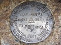 view gallery view gallery NE27.4 km NE27.4 km
|  70 RBR 1964 - near Medical Springs, Oregon 70 RBR 1964 - near Medical Springs, Oregon
in U.S. Benchmarks A USGS disk along Highway 203 between Union, Oregon and Medical Springs, Oregon. posted by: TillaMurphs location: Oregon date approved: 05/01/2012 last visited: never |
 view gallery view galleryN29.6 km | Union County Airport - La Grande, Oregon - 2714' in Elevation Signs The sign is located at the La Grande - Union County Airport. posted by: WR7X location: Oregon date approved: 07/27/2015 last visited: 11/27/2020 |
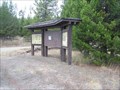 view gallery view gallerySW29.9 km | Crane Flats Kiosk in Oregon Historical Markers Kiosk with two history sign along F.S. Rd 73 at Crane Flats. posted by: Volcanoguy location: Oregon date approved: 01/02/2008 last visited: 11/25/2020 |
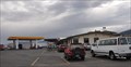 view gallery view galleryN30.1 km |  Shell Flying J Truck Stop Free WiFi Shell Flying J Truck Stop Free WiFi
in Wi-Fi Hotspots Free WiFi at the Shell Flying J Truck Stop located at Interstate Highway 84 Exit 265 southeast of La Grande. posted by: brwhiz location: Oregon date approved: 12/07/2013 last visited: never |
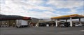 view gallery view galleryN30.1 km |  Shell Flying J Truck Stop Shell Flying J Truck Stop
in Truck Stops This Truck Stop is located at Interstate Highway 84 Exit 265 southeast of La Grande. posted by: brwhiz location: Oregon date approved: 12/04/2013 last visited: 11/27/2020 |
 view gallery view gallerySE30.3 km | Baker City Airport - 3373' in Elevation Signs The sign is located along the Frontage Road, east side of I-84, north of Baker City, Oregon. posted by: WR7X location: Oregon date approved: 07/07/2012 last visited: 11/27/2020 |
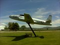 view gallery view gallerySE30.6 km |  Baker City T33 Baker City T33
in Static Aircraft Displays This a T33 on display at the Baker County Airport. It has a picnic
table if you are looking for a shady spot. posted by: Seek&Find location: Oregon date approved: 06/21/2010 last visited: 06/18/2010 |
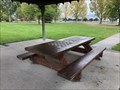 view gallery view galleryN31.7 km |  Chessboard Picnic Table - La Grande, OR Chessboard Picnic Table - La Grande, OR
in Eagle Scout Project Sites A chessboard picnic table at Birnie Park in La Grande, Oregon. posted by: Rock Chalk location: Oregon date approved: 10/18/2020 last visited: 11/27/2020 |
|