 view gallery view gallery E6 km E6 km
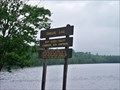
|   Bennett-Bean Bridge - Wilson Mills, ME Bennett-Bean Bridge - Wilson Mills, ME
in Covered Bridges The Bennett-Bean Bridge is located in the Aziscoos Valley Camping Area off Route 16, near Wilson Mills, Maine. posted by:  macdonr macdonr location: Maine date approved: 09/10/2006 last visited: 04/13/2005 |
 view gallery view gallery SE8.9 km SE8.9 km
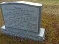
|  Bean'Family- Wentwoth Location - New Hampshire Bean'Family- Wentwoth Location - New Hampshire
in Graves Mentioning a Cause of Death Graves of Unusual Deaths on the road posted by:  gemeloj gemeloj location: New Hampshire date approved: 05/27/2018 last visited: 10/16/2018 |
 view gallery view gallery S15 km S15 km
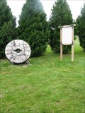
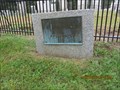
|  Grist Mill Stone, Errol, New Hampshire Grist Mill Stone, Errol, New Hampshire
in Old Agricultural Equipment This grist mill was first used in 1853. posted by: Queens Blessing location: New Hampshire date approved: 10/21/2012 last visited: 10/17/2018 |
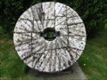 view gallery view galleryS15 km |  Grist Mill Stone, Errol, New Hampshire Grist Mill Stone, Errol, New Hampshire
in Millstones This grist mill was first used in 1853. posted by: Queens Blessing location: New Hampshire date approved: 08/17/2013 last visited: 10/17/2018 |
 view gallery view galleryS15 km |  Connecticut River Scenic Byway in New Hampshire Connecticut River Scenic Byway in New Hampshire
in National Scenic Byways This is a National Scenic Byway that is about 500 miles long. posted by: Queens Blessing location: New Hampshire date approved: 10/20/2012 last visited: 10/17/2018 |
 view gallery view gallery W15.8 km W15.8 km
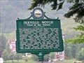
|  Dixville Notch Dixville Notch
in New Hampshire Historical Markers The Dixville Notch historical Marker memorializes the spot of the 1920 Democratic Primaries. posted by: GT.US location: New Hampshire date approved: 06/06/2010 last visited: 07/31/2019 |
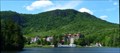 view gallery view galleryW15.9 km |  Balsams, The - Dixville NH Balsams, The - Dixville NH
in U.S. National Register of Historic Places Located on RT 26 in Dixville, NH, the Balsams is one of the great luxury resort hotels built in the White Mountains. It was started in 1874 and completed in 1915. posted by: nomadwillie location: New Hampshire date approved: 07/02/2012 last visited: 07/31/2019 |
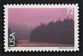 view gallery view galleryS20 km |  13-Mile Woods and Androscoggin River, New Hampshire 13-Mile Woods and Androscoggin River, New Hampshire
in Philatelic Photographs This 2008 stamp shows a fog-shrouded Androscoggin River as it winds through the 13-Mile Woods conservation area in northern Hew Hampshire. posted by: hykesj location: New Hampshire date approved: 05/15/2018 last visited: 10/17/2018 |
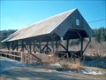 view gallery view gallery NW23.3 km NW23.3 km
| River Road Bridge in Covered Bridges This and the Happy Corner Bridge share being the northernmost covered bridges in New Hampshire posted by: CoveredBridgeGuy location: New Hampshire date approved: 12/07/2006 last visited: never |
 view gallery view galleryS24 km |  Umbagog Lake Boat Launch Umbagog Lake Boat Launch
in Boat Ramps This small launch is located on Umbagog lake near Errol New Hampshire. posted by: GT.US location: New Hampshire date approved: 06/08/2010 last visited: 09/03/2012 |
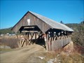 view gallery view galleryNW24.6 km | Happy Corner Bridge in Covered Bridges The most northern of New Hampshire's authentic covered bridges posted by: CoveredBridgeGuy location: New Hampshire date approved: 12/06/2006 last visited: 05/23/2009 |
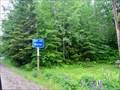 view gallery view galleryS24.8 km |  NH - Maine Border - Hwy 26 NH - Maine Border - Hwy 26
in Border Crossings This crossing is on Route 26 is almost a non-event. posted by: GT.US location: New Hampshire date approved: 06/06/2010 last visited: 08/11/2017 |
 view gallery view galleryW25.1 km |  North Hill Cemetery, Pittsburg, New Hampshire North Hill Cemetery, Pittsburg, New Hampshire
in Worldwide Cemeteries This is a small country cemetery but it is filled with history. posted by: Queens Blessing location: New Hampshire date approved: 10/23/2012 last visited: 04/06/2013 |
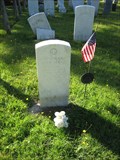 view gallery view galleryW25.1 km |  Norman Clark - Stewartstown, NH Norman Clark - Stewartstown, NH
in American Revolutionary War Veteran Graves The final resting place of Revolutionary War veteran Norman Clark posted by: cache_test_dummies location: New Hampshire date approved: 10/03/2009 last visited: 09/04/2012 |
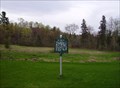
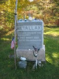 view gallery view galleryW25.1 km |  Metallak Metallak
in Grave of a Famous Person Possibly the last remaining member of the Arosaguntacook band of the Abenakis, this legendary figure was reported to have lived to the age of 120. posted by: cache_test_dummies location: New Hampshire date approved: 09/27/2009 last visited: 09/03/2012 |
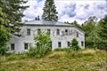 view gallery view galleryS25.7 km |  Former Upton Grange No. 404 - Upton ME Former Upton Grange No. 404 - Upton ME
in Wikipedia Entries The Former Upton Grange No. 404 is a historic former Grange hall on Maine State Route 26 in rural Upton, Maine. posted by: nomadwillie location: Maine date approved: 01/17/2018 last visited: never |
 view gallery view galleryS25.7 km | Upton Grange No. 404 (Former) - Upton ME in U.S. National Register of Historic Places The Former Upton Grange No. 404 is a historic former Grange hall on Maine State Route 26 in rural Upton, Maine. posted by: nomadwillie location: Maine date approved: 01/19/2018 last visited: never |
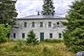 view gallery view galleryS25.7 km |  Upton Grange No. 404 (former) - Upton ME Upton Grange No. 404 (former) - Upton ME
in Grange Halls It was first used as a factory for the manufacture of spruce gum before being acquired by the local Grange chapter in 1911, and was used for social events as well as town meetings. posted by: nomadwillie location: Maine date approved: 02/04/2018 last visited: never |
 view gallery view galleryS25.7 km |  Bragg Spruce Gum Factory - Upton ME Bragg Spruce Gum Factory - Upton ME
in Converted Factories The main block of the building was constructed in 1899 by Frank W. Bragg, a local resident who set up a spruce gum manufacturing operation on the premises. posted by: nomadwillie location: Maine date approved: 03/23/2018 last visited: never |
 view gallery view galleryW25.9 km | 45th Parallel (Clarksville) in New Hampshire Historical Markers 45th Parallel (Clarksville) posted by: silverquill location: New Hampshire date approved: 05/15/2006 last visited: 07/31/2019 |
 view gallery view gallery N25.9 km N25.9 km
|  Second Connecticut Lake - Pittsburg, NH Second Connecticut Lake - Pittsburg, NH
in Fishing Holes Here is a great trout lake/river in New Hampshire's north country where the great Connecticut River is just a stream! posted by: silverquill location: New Hampshire date approved: 04/27/2007 last visited: 09/03/2012 |
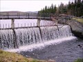
 view gallery view galleryN25.9 km |  Second Connecticut Lake-River - Pittsburg, NH Second Connecticut Lake-River - Pittsburg, NH
in Water Dams The three Connecticut Lakes in the far northern tip of New Hampshire are the origin of the mighty Connecticut River that forms most of the border between New Hampshire and Vermont. This dam is on the south end of the Second Connecticut Lake. posted by: silverquill location: New Hampshire date approved: 04/27/2007 last visited: 09/03/2012 |
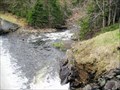
 view gallery view galleryN25.9 km |  Second Connecticut Lake-River - Pittsburg, NH Second Connecticut Lake-River - Pittsburg, NH
in Man-made Waterfalls This waterfall is the outflow from the Second Connecticut Lake. At this point it is still a stream, but as it gathers streams in its flow south, it becomes the Connecticut River which forms most of the border between New Hampshire and Vermont. posted by: silverquill location: New Hampshire date approved: 04/27/2007 last visited: 09/03/2012 |
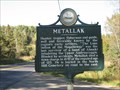 view gallery view galleryW26.1 km | Metallak in New Hampshire Historical Markers A marker memorializing the life of Metallak, the last remaining member of the Arosaguntacook band of the Abenaki tribe. posted by: cache_test_dummies location: New Hampshire date approved: 09/27/2009 last visited: 07/31/2019 |
 view gallery view galleryNW26.4 km |  Guestbook, VIC Pittsburg, New Hampshire Guestbook, VIC Pittsburg, New Hampshire
in Guest Books This tiny town of 300 has a guest book in the visitor information center. posted by: Queens Blessing location: New Hampshire date approved: 10/21/2012 last visited: 09/02/2013 |
|