 view gallery view gallery E12.1 km E12.1 km
|   Haines Cemetery - Haines, OR Haines Cemetery - Haines, OR
in Worldwide Cemeteries Cemetery for the community of Haines, Oregon. posted by:  Volcanoguy Volcanoguy location: Oregon date approved: 01/04/2008 last visited: 11/27/2020 |
 view gallery view galleryE12.1 km |  WOW - Young - Haines, Oregon WOW - Young - Haines, Oregon
in Woodmen of the World Grave Markers/Monuments A wonderful example of Woodmen of the World grave memorial posted by: redheadsrule location: Oregon date approved: 10/13/2010 last visited: 11/27/2020 |
 view gallery view galleryE12.2 km |  Haines, OR, 97833 Haines, OR, 97833
in U.S. Post Offices The Haines, OR Post Office.
posted by: Volcanoguy location: Oregon date approved: 10/15/2007 last visited: 11/27/2020 |
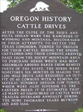 view gallery view galleryE12.2 km |  Cattle Drives Cattle Drives
in Oregon Historical Markers Oregon History Sign about Cattle Drives at Haines, Oregon. posted by: Volcanoguy location: Oregon date approved: 10/29/2007 last visited: 11/25/2020 |
 view gallery view galleryE12.2 km |  Dick Camp Memorial Park - Haines, OR Dick Camp Memorial Park - Haines, OR
in Municipal Parks and Plazas The Dick Camp Memorial Park is located between Hwy 30 and the railroad tracks in Haines, Oregon. posted by: Volcanoguy location: Oregon date approved: 01/05/2008 last visited: 11/27/2020 |
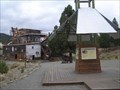
 view gallery view galleryE12.6 km |  Haines, OR - 3336' Haines, OR - 3336'
in Elevation Signs The sign is located on the relocated railroad depot at the Eastern Oregon Museum in Haines. posted by: WR7X location: Oregon date approved: 11/17/2019 last visited: 11/27/2020 |
 view gallery view gallery NW12.6 km NW12.6 km
| Anthony Lake Guard Station - North Powder, OR - 7100' in Elevation Signs The sign is in front of the Anthony Lake Guard Station just off Forest Road 73 in the Wallowa-Whitman National Forest. posted by: WR7X location: Oregon date approved: 07/30/2016 last visited: 11/27/2020 |
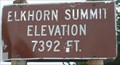 view gallery view galleryNW14.5 km | 7392 Feet, Elkhorn Summit, OR in Elevation Signs Elevation sign at Elkhorn Summit near Anthony Lakes Ski Area. posted by: Volcanoguy location: Oregon date approved: 01/03/2008 last visited: 11/27/2020 |
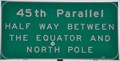 view gallery view gallery NE18.3 km NE18.3 km
|  45th Parallel Sign ~ Union County, Oregon 45th Parallel Sign ~ Union County, Oregon
in Great Lines of Earth This sign marks the 45th Parallel, halfway between the Equator and the North Pole. It is just south of the junction of US Highway 30 and Interstate Highway 84 in the middle of nowhere about midway between La Grande and Baker City. posted by: brwhiz location: Oregon date approved: 03/31/2014 last visited: 11/27/2020 |
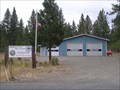 view gallery view gallery SW19.3 km SW19.3 km
|  Mosquito Flat Fire Station Mosquito Flat Fire Station
in Firehouses Mosquito Flat Fire Station of the Powder River Rural Fire Department. posted by: Volcanoguy location: Oregon date approved: 10/26/2007 last visited: 11/27/2020 |
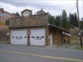 view gallery view gallerySW19.3 km | Sumpter Volunteer Fire Dept Station #33 in Firehouses Sumpter Volunteer Fire Dept. station in Sumpter, Oregon. posted by: Volcanoguy location: Oregon date approved: 01/03/2008 last visited: 11/27/2020 |
 view gallery view gallerySW19.3 km | Site of Bank of Sumpter in Oregon Historical Markers History sign in Sumpter, Oregon posted by: Volcanoguy location: Oregon date approved: 01/02/2008 last visited: 11/25/2020 |
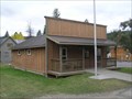
 view gallery view galleryNE19.5 km | North Powder, Oregon 97867 in U.S. Post Offices This Post Office is located at 205 E Street in North Powder, Oregon. posted by: brwhiz location: Oregon date approved: 11/10/2013 last visited: 11/27/2020 |
 view gallery view galleryNE19.5 km |  Gazebo - North Powder, Oregon Gazebo - North Powder, Oregon
in Gazebos Town center Gazebo, meeting place, band-stand posted by: n2life location: Oregon date approved: 07/09/2013 last visited: 11/27/2020 |
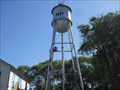 view gallery view galleryNE19.5 km |  North Powder, OR Water Tower North Powder, OR Water Tower
in Water Towers This is the water tower for the city of North Powder, OR. The
smaller picture was snapped from the main street going thru town.
The town was incorporated in the early 1900's. posted by: n2life location: Oregon date approved: 07/10/2013 last visited: never |
 view gallery view gallerySW19.6 km | Sumpter, OR, 97877 in U.S. Post Offices The Sumpter, OR Post Office. posted by: Volcanoguy location: Oregon date approved: 10/15/2007 last visited: 11/27/2020 |
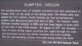 view gallery view gallerySW19.8 km | Sumpter, Oregon in Oregon Historical Markers History sign in Sumpter, Oregon posted by: Volcanoguy location: Oregon date approved: 01/02/2008 last visited: 11/25/2020 |
 view gallery view gallerySW19.8 km |  Sumpter Valley Railroad, Sumpter Station - Oregon Sumpter Valley Railroad, Sumpter Station - Oregon
in Scenic Railroads The Sumpter Valley Railroad operates over five miles of track between Sumpter and McEwen stations. posted by: Volcanoguy location: Oregon date approved: 01/02/2008 last visited: 11/27/2020 |
 view gallery view gallerySW19.8 km | Sumpter Depot - Sumpter, Oregon in Train Stations/Depots The Sumpter Valley Scenic Railroad’s McEwen Depot was built in about 1995. posted by: Volcanoguy location: Oregon date approved: 01/02/2008 last visited: 11/27/2020 |
 view gallery view gallerySW20 km | Raising Her Up Again in Oregon Historical Markers History sign at Sumpter Valley Dredge posted by: Volcanoguy location: Oregon date approved: 01/02/2008 last visited: 11/25/2020 |
 view gallery view gallerySW20 km | A System of Levers and Winches in Oregon Historical Markers History sign at Sumpter Valley Dredge posted by: Volcanoguy location: Oregon date approved: 01/02/2008 last visited: 11/25/2020 |
 view gallery view gallerySW20 km | The Inside Scoop in Oregon Historical Markers History sign at Sumpter Valley Dredge posted by: Volcanoguy location: Oregon date approved: 01/02/2008 last visited: 11/25/2020 |
 view gallery view gallerySW20 km | Sumpter Valley Dredge Kiosk in Oregon Historical Markers Four history signs in kiosk at the Sumpter Valley Dredge. posted by: Volcanoguy location: Oregon date approved: 01/02/2008 last visited: 11/25/2020 |
 view gallery view gallerySW20 km |  Sumpter Valley Gold Dredge Sumpter Valley Gold Dredge
in U.S. National Register of Historic Places The Sumpter Valley Gold Dredge at Sumpter, Oregon posted by: Volcanoguy location: Oregon date approved: 12/25/2007 last visited: 11/27/2020 |
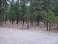 view gallery view gallery S20.4 km S20.4 km
| Sumpter Cemetery - Sumpter, OR in Worldwide Cemeteries Cemetery for the community of Sumpter, Oregon. posted by: Volcanoguy location: Oregon date approved: 01/02/2008 last visited: 11/27/2020 |
|