 view gallery view gallery N19.8 km N19.8 km
|   Beartooth Pass - US 212 - MT/WY Beartooth Pass - US 212 - MT/WY
in Border Crossings On US 212, which the Beartooth Pass approaching Montana from Wyoming. posted by:  nomadwillie nomadwillie location: Wyoming date approved: 04/02/2011 last visited: 08/03/2012 |
 view gallery view gallery NW20.4 km NW20.4 km
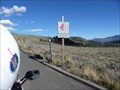
|  Beartooth Highway - Wyoming / Montana Beartooth Highway - Wyoming / Montana
in National Scenic Byways The Beartooth Highway is an All-American Road that has been called "the most beautiful drive in America," by late CBS correspondent Charles Kuralt. posted by: nomadwillie location: Wyoming date approved: 06/22/2011 last visited: 09/02/2019 |
 view gallery view gallery SE25.4 km SE25.4 km
| Chief Joseph Scenic Highway - Wyoming in National Scenic Byways Wyoming 296 winds for 46 miles follows the route Chief Joseph led the Nez Perce Indians out of Yellowstone Park into Montana. WY 296 terminates at the beginning of the Beartooth Highway posted by: nomadwillie location: Wyoming date approved: 06/22/2011 last visited: 09/15/2019 |
 view gallery view gallery E29.9 km E29.9 km
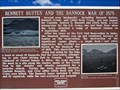
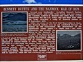
|  Bennett Buttes and the Bannock War of 1878 - Park County, WY Bennett Buttes and the Bannock War of 1878 - Park County, WY
in Wyoming Historical Markers Along Highway 120 north of Cody, about 9.5 miles south of the Montana border is a pullout with a pair of Wyoming Historical Markers. This marker tells of the Bannock War, a part of which took place nearby. posted by: T0SHEA location: Wyoming date approved: 09/06/2017 last visited: never |
 view gallery view galleryE29.9 km |  The Bannock War of 1878 - Park County, WY The Bannock War of 1878 - Park County, WY
in Battlefields Along Highway 120 north of Cody, about 9.5 miles south of the Montana border is a pullout with a pair of Wyoming Historical Markers. This marker tells of the Bannock War, a part of which took place nearby. posted by: T0SHEA location: Wyoming date approved: 02/11/2022 last visited: never |
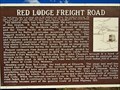 view gallery view galleryE29.9 km | Red Lodge Freight Road - Park County, WY in Wyoming Historical Markers Along Highway 120 north of Cody, about 9.5 miles south of the Montana border is a pullout with a pair of Wyoming Historical Markers. This marker was placed to impart some of the history of the road which brings one to the marker. posted by: T0SHEA location: Wyoming date approved: 09/06/2017 last visited: never |
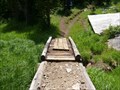
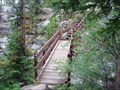
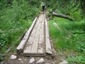 view gallery view galleryNW33 km |  Footbridge on the East Rosebud Trail northwest of Fox Lake - Montana Footbridge on the East Rosebud Trail northwest of Fox Lake - Montana
in Hiking Path Footbridges Located on the 26 mile East Rosebud Trail in the Absaroka Beartooth Wilderness. posted by:  CM-14 CM-14 location: Montana date approved: 08/18/2007 last visited: never |
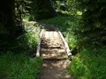 view gallery view galleryNW33 km | Footbridge on the East Rosebud Trail west of Russell Creek - Montana in Hiking Path Footbridges Located on the 26 mile East Rosebud Trail in the Absaroka Beartooth Wilderness. posted by: CM-14 location: Montana date approved: 08/18/2007 last visited: never |
 view gallery view galleryNW33 km | Footbridge on the East Rosebud Trail northeast of Twin Lakes - Montana in Hiking Path Footbridges Located on the 26 mileEast Rosebud Trail in the Absaroka Beartooth Wilderness. posted by: CM-14 location: Montana date approved: 08/18/2007 last visited: never |
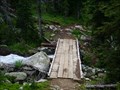
 view gallery view galleryNW33.5 km | Footbridge on the East Rosebud Trail south of Russell Lake - Montana in Hiking Path Footbridges Located on the 26-mile East Rosebud Trail in the Absaroka Beartooth Wilderness just south of Russell Lake. posted by: CM-14 location: Montana date approved: 08/15/2007 last visited: never |
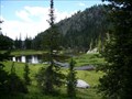
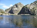
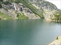
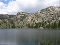 view gallery view galleryNW33.5 km |  Russell Lake - Montana Russell Lake - Montana
in Fishing Holes Located along the Russell Creek trail in the Gallatin National Forest. posted by: CM-14 location: Montana date approved: 07/29/2007 last visited: never |
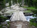
 view gallery view galleryNW33.5 km | Footbridge on the East Rosebud Trail near Russell Lake - Montana in Hiking Path Footbridges A short bridge over Russell Creek in the Galatin National Forest on the 26 mile East Rosebud Trail. posted by: CM-14 location: Montana date approved: 08/14/2007 last visited: never |
 view gallery view galleryNW33.6 km | Kersey Lake - Montana in Fishing Holes Located along the Russell Creek Trail in the Gallatin National Forest. Part of the forest around the lake was burned several years back and is recovering nicely. posted by: CM-14 location: Montana date approved: 07/29/2007 last visited: never |
 view gallery view gallery NE34 km NE34 km
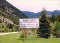
|  Day-Reasonable and Prudent - Red Lodge MT Day-Reasonable and Prudent - Red Lodge MT
in Unusual Signs This sign is unusual in that it does not show a speed limit for the DAY- only "Reasonable and Prudent". In my travels I have never seen a speed sign without a number. posted by: Don.Morfe location: Montana date approved: 10/25/2022 last visited: 10/11/2022 |
 view gallery view galleryNW34.3 km | Un-named Pond in the Absaroka Beartooth Wilderness - Montana in Fishing Holes Located in the Abasaroka-Beartooth Wilderness along the East Rosebud Trail. Small pond teeming with trout. posted by: CM-14 location: Montana date approved: 07/27/2007 last visited: never |
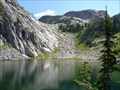 view gallery view galleryNW34.9 km | Ouzel Lake - Montana in Fishing Holes Located in the Absaroka-Beartooth Wilderness along the East Rosebud Trail. Plenty of lake trout here. posted by: CM-14 location: Montana date approved: 07/27/2007 last visited: never |
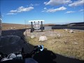
 view gallery view galleryNW34.9 km |  Western Smelting and Power Company's Hydroelectric Generating Plant - Cooke City, MT Western Smelting and Power Company's Hydroelectric Generating Plant - Cooke City, MT
in Photos Then and Now The debris below you is the remains of the Western Smelting and Power Company's hydroelectric generating plant. posted by: CM-14 location: Montana date approved: 07/30/2007 last visited: never |
 view gallery view galleryNW35.1 km | Footbridge on the Russell Creek Trail near the trailhead - Montana in Hiking Path Footbridges Located just after the the start of the Russell Creek Trail near Cooke City, Montana. posted by: CM-14 location: Montana date approved: 08/18/2007 last visited: never |
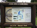 view gallery view galleryNW35.1 km |  "You Are Here" Map @ Gallatin National Forest, Flume Trail - Montana "You Are Here" Map @ Gallatin National Forest, Flume Trail - Montana
in 'You Are Here' Maps Located in the Gallatin Naltional Forest just off US212 near Cooke City. posted by: CM-14 location: Montana date approved: 07/29/2007 last visited: never |
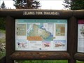 view gallery view galleryNW35.1 km | "You Are Here" Map @ Absaroka-Beartooth Wilderness, Clarks Fork Trailhead - Montana in 'You Are Here' Maps Located at the Clarks Fork Trailhead off US212 near Cooke City. posted by: CM-14 location: Montana date approved: 07/29/2007 last visited: never |
 view gallery view galleryNW35.2 km | Un-named Lake on Russel Creek - Montana in Fishing Holes This un-name lake is located in the Custer National Forest on Russell Creek. It is accessible via an 8 mile hike on the Russell Creek trail from the listed parking coordinates. Great trout fishing. posted by: CM-14 location: Montana date approved: 07/25/2007 last visited: never |
 view gallery view gallerySE35.4 km |  Heart Mountain - Wyoming Heart Mountain - Wyoming
in Wikipedia Entries Also known as Heart Mountain Butte, Heart Mountain is a genuine anomaly, bordering on the unique. posted by: T0SHEA location: Wyoming date approved: 04/20/2019 last visited: never |
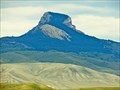 view gallery view gallerySE35.4 km |  Heart Mountain - Ralston, Wyoming Heart Mountain - Ralston, Wyoming
in Places of Geologic Significance Also known as Heart Mountain Butte, Heart Mountain is a genuine anomaly, bordering on the unique. posted by: T0SHEA location: Wyoming date approved: 04/26/2019 last visited: never |
 view gallery view galleryNW35.7 km | Lake At Falls - Montana in Fishing Holes Located in the Custer National Forest via a 9 mile one-way hike from the listed pariking coordinates. posted by: CM-14 location: Montana date approved: 07/22/2007 last visited: never |
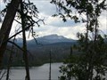
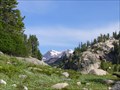 view gallery view galleryNW35.9 km |  Scenic Overlook: Mount Villard and an Un-named Lake - Montana Scenic Overlook: Mount Villard and an Un-named Lake - Montana
in Scenic Overlooks This overlook on the Russell Creek trail in the Custer National Forest provides a view of Mount Villard in one direction and an un-named Lake in the other.
posted by: CM-14 location: Montana date approved: 07/26/2007 last visited: never |
|