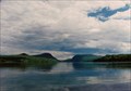
 view gallery view gallery SE6.9 km SE6.9 km
|   Lake Willoughby, Vermont Lake Willoughby, Vermont
in Places of Geologic Significance Glacial trough. posted by:  Vermontish Vermontish location: Vermont date approved: 06/27/2008 last visited: 11/19/2016 |
 view gallery view gallerySE6.9 km |  Lake Willoughby Natural Area Lake Willoughby Natural Area
in U.S. National Natural Landmarks Glacial trough. posted by: Vermontish location: Vermont date approved: 06/30/2008 last visited: 11/19/2016 |
 view gallery view gallery NE9 km NE9 km
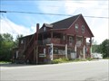
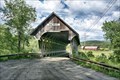
|  Free Will Baptist Church - West Charleston, Vermont Free Will Baptist Church - West Charleston, Vermont
in This Old Church Church is over 166 years old posted by: Vermontish location: Vermont date approved: 07/21/2009 last visited: 11/19/2016 |
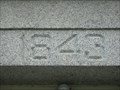 view gallery view galleryNE9 km |  1843 Church - West Charleston, Vermont 1843 Church - West Charleston, Vermont
in Dated Buildings and Cornerstones Church is over 166 years old posted by: Vermontish location: Vermont date approved: 07/21/2009 last visited: 11/19/2016 |
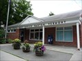
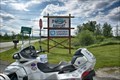
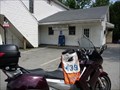 view gallery view galleryNE9 km |  West Charleston, VT 05872 West Charleston, VT 05872
in U.S. Post Offices 1165 Vt Route 105, West Charleston, VT posted by:  nomadwillie nomadwillie location: Vermont date approved: 05/17/2011 last visited: 11/19/2016 |
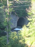 view gallery view gallery SW10 km SW10 km
|  The High Bridge - Barton, Vermont The High Bridge - Barton, Vermont
in Arch Bridges Stone arch railroad bridge posted by: Vermontish location: Vermont date approved: 07/05/2008 last visited: 08/20/2015 |
 view gallery view gallerySW10 km | Barton, VT 05822 in U.S. Post Offices Located at 405 Main Street, Barton, VT posted by: nomadwillie location: Vermont date approved: 05/17/2011 last visited: 08/20/2015 |
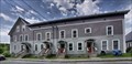 view gallery view gallerySW10 km |  King Block (Barton, Vermont) King Block (Barton, Vermont)
in Wikipedia Entries The King Block is a historic apartment house at 117 High Street, Barton, Vermont, United States. Built in 1870 and expanded several times, it is a well-preserved example of tenement-style worker housing of the late 19th century. posted by: nomadwillie location: Vermont date approved: 02/18/2023 last visited: never |
 view gallery view gallerySW10 km |  King Block - Barton VT King Block - Barton VT
in U.S. National Register of Historic Places The King Block is a historic apartment house at 117 High Street, Barton, Vermont, United States. Built in 1870 and expanded several times, it is a well-preserved example of tenement-style worker housing of the late 19th century. posted by: nomadwillie location: Vermont date approved: 02/18/2023 last visited: never |
 view gallery view gallery S10.1 km S10.1 km
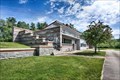
| Crystal Lake State Park - Barton VT in U.S. National Register of Historic Places Crystal Lake State Park features a sandy beach with swimming area, and a bath house built by the Civilian Conservation Corps (CCC). posted by: nomadwillie location: Vermont date approved: 02/23/2023 last visited: never |
 view gallery view galleryS10.1 km | Crystal Lake State Park - Barton VT in Wikipedia Entries Crystal Lake State Park features a sandy beach with swimming area, and a bath house built by the Civilian Conservation Corps (CCC). posted by: nomadwillie location: Vermont date approved: 02/20/2023 last visited: never |
 view gallery view galleryS10.1 km |  Crystal Lake State Park (Co 1160) - Barton VT Crystal Lake State Park (Co 1160) - Barton VT
in Civilian Conservation Corps Crystal Lake State Park features a sandy beach with swimming area, and a bath house built by the Civilian Conservation Corps (CCC). posted by: nomadwillie location: Vermont date approved: 02/20/2023 last visited: never |
 view gallery view galleryS10.1 km |  Crystal Lake State Park - Barton VT Crystal Lake State Park - Barton VT
in State/Provincial Parks Crystal Lake State Park features a sandy beach with swimming area, and a bath house built by the Civilian Conservation Corps (CCC). posted by: nomadwillie location: Vermont date approved: 02/20/2023 last visited: never |
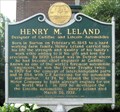 view gallery view gallerySW10.1 km |  Henry M. Leland - Barton Henry M. Leland - Barton
in Vermont Historical Markers Notable automotive designer and engineer posted by: Vermontish location: Vermont date approved: 07/18/2010 last visited: 10/21/2018 |
 view gallery view gallery NW10.3 km NW10.3 km
| Northeast Kingdom International Airport - Newport, VT in Wikipedia Entries Northeast Kingdom International Airport, until 2015 the Newport State Airport (IATA: EFK, ICAO: KEFK, FAA LID: EFK), is three miles (5 km) southwest of Newport, in Orleans County, Vermont, United States. posted by: nomadwillie location: Vermont date approved: 02/16/2023 last visited: never |
 view gallery view galleryNW10.3 km |  Northeast Kingdom International Airport - Newport, VT Northeast Kingdom International Airport - Newport, VT
in Airports Northeast Kingdom International Airport, until 2015 the Newport State Airport (IATA: EFK, ICAO: KEFK, FAA LID: EFK), is three miles (5 km) southwest of Newport, in Orleans County, Vermont, United States. posted by: nomadwillie location: Vermont date approved: 02/17/2023 last visited: never |
 view gallery view gallery E10.5 km E10.5 km
| Sweeney, J. S., Store, Barn, Livery and Hall - East Charleston, Vermont in U.S. National Register of Historic Places Old-time General Store posted by: Vermontish location: Vermont date approved: 07/21/2009 last visited: never |
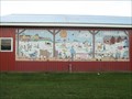 view gallery view gallerySW11.1 km |  Farm Scene - Barton, Vermont Farm Scene - Barton, Vermont
in Murals Cartoon farm scene on a fairgrounds building posted by: Vermontish location: Vermont date approved: 07/08/2008 last visited: never |
 view gallery view gallerySW11.1 km |  Fourth of July - Barton, Vermont Fourth of July - Barton, Vermont
in Fireworks Displays Nice display for a small town posted by: Vermontish location: Vermont date approved: 08/03/2008 last visited: never |
 view gallery view gallery W11.3 km W11.3 km
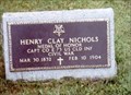
|  Henry Clay Nichols-Coventry, VT Henry Clay Nichols-Coventry, VT
in Medal Of Honor Resting Places Civil War Medal of Honor Recipient for action at Fort Blakely, AL on April 9, 1865. He is buried in Coventry Village Cemetery, Coventry, VT. posted by: Don.Morfe location: Vermont date approved: 01/21/2019 last visited: 12/06/2021 |
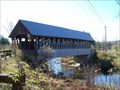
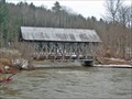 view gallery view galleryW11.6 km |  Lord's Creek Bridge Lord's Creek Bridge
in Covered Bridges This bridge presents an excellent opportunity to see the skeletal structure of a Paddleford Truss posted by: CoveredBridgeGuy location: Vermont date approved: 01/04/2007 last visited: 07/02/2009 |
 view gallery view galleryW12.4 km |  Orne Covered Bridge - Irasburg, VT Orne Covered Bridge - Irasburg, VT
in Truss Bridges The Orne Covered Bridge stands in far northern Irasburg, just south of the main village of Coventry, on Back Coventry Road. It is a single-span Paddleford truss structure, oriented in a roughly east–west direction across the Black River. posted by: nomadwillie location: Vermont date approved: 02/16/2023 last visited: 04/06/2024 |
 view gallery view galleryW12.4 km | Orne Covered Bridge - Irasburg, VT in Wikipedia Entries The Orne Covered Bridge is a replica of a historic bridge on Back Coventry Road in Irasburg, Vermont. Built in 2000, it is a replacement for a 19th-century bridge which stood on the site until it was destroyed by arson in 1997. posted by: nomadwillie location: Vermont date approved: 02/16/2023 last visited: never |
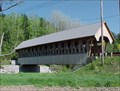 view gallery view galleryW12.4 km | Orne Covered Bridge - Coventry, VT in U.S. National Register of Historic Places Restored bridge posted by: Vermontish location: Vermont date approved: 06/22/2009 last visited: 02/16/2023 |
 view gallery view galleryW12.4 km | Orne Bridge in Covered Bridges A unique feature about this bridge is that it was built with a 14 panel Paddleford truss representing the 14 counties in VT and VT was the 14th state to enter the Union. posted by: CoveredBridgeGuy location: Vermont date approved: 01/06/2007 last visited: 02/16/2023 |
|