 view gallery view gallery SW2.4 km SW2.4 km
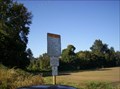
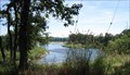
|   Buena Vista Ferry Buena Vista Ferry
in Ferries and Ferry Landings This ferry connects the two sides of the Willamette River between Independence and Albany. posted by:  shadow101 shadow101 location: Oregon date approved: 09/18/2007 last visited: 10/24/2014 |
 view gallery view gallery W2.7 km W2.7 km
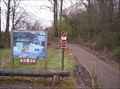
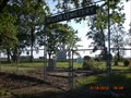
|  Buena Vista Cemetery - Polk County, Oregon Buena Vista Cemetery - Polk County, Oregon
in Worldwide Cemeteries Graveyard in rural Polk County, Oregon posted by: ddtfamily location: Oregon date approved: 11/05/2012 last visited: never |
 view gallery view gallery E3.2 km E3.2 km
|  Rail Trail - Ankeny National Wildlife Refuge - near Jefferson, Oregon Rail Trail - Ankeny National Wildlife Refuge - near Jefferson, Oregon
in Non-Coastal Boardwalks One of two boardwalks in this refuge along the Willamette River. posted by: shadow101 location: Oregon date approved: 03/24/2009 last visited: 05/06/2021 |
 view gallery view gallery NE5 km NE5 km
|  Ankeny National Wildlife Refuge - Oregon Ankeny National Wildlife Refuge - Oregon
in National Wildlife Refuges Ankeny National Wildlife Refuge contains 2,796 acres of flat to gentle rolling land located near the confluence of the Willamette and Santiam rivers. The refuge's fertile farmed fields,hedgerows, forest, and wetlands abound with wildlife. posted by:  Bandmaster Bandmaster location: Oregon date approved: 08/18/2007 last visited: 06/09/2008 |
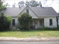 view gallery view galleryE5.5 km |  Anderson, James Mechlin, House - Jefferson, Oregon Anderson, James Mechlin, House - Jefferson, Oregon
in U.S. National Register of Historic Places The James Mechlin Anderson House near Jefferson, Oregon posted by: ddtfamily location: Oregon date approved: 08/28/2012 last visited: 05/18/2013 |
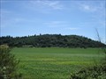 view gallery view galleryE6 km |  Looney Butte - Marion County, Oregon Looney Butte - Marion County, Oregon
in American Guide Series Butte named for the pioneering Looney family posted by: ddtfamily location: Oregon date approved: 07/01/2013 last visited: never |
 view gallery view galleryE6.6 km |  Emerald Valley RV Park - near Jefferson, Oregon Emerald Valley RV Park - near Jefferson, Oregon
in Neon Signs The neon sign for this newish RV park is right along I-5. posted by: shadow101 location: Oregon date approved: 11/27/2012 last visited: 11/26/2012 |
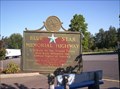 view gallery view gallery SE6.8 km SE6.8 km
|  Interstate 5, north of Albany, OR Interstate 5, north of Albany, OR
in Blue Star Memorial Highway Markers This marker is in the northbound side of the Santiam River rest stop. posted by: shadow101 location: Oregon date approved: 09/14/2007 last visited: 05/23/2013 |
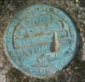
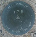 view gallery view gallerySW6.8 km |  POLK COUNTY GPS SURVEY MONUMENT 176 1994 POLK COUNTY GPS SURVEY MONUMENT 176 1994
in U.S. Benchmarks A benchmark not in the geocaching.com database, but in the NGS database posted by: MIG2 location: Oregon date approved: 12/11/2011 last visited: never |
 view gallery view gallerySE7.1 km |  Woolridge Airstrip - near Millersburg, Oregon Woolridge Airstrip - near Millersburg, Oregon
in Airports Private rural airstrip out in the Oregon farm country. posted by: shadow101 location: Oregon date approved: 06/06/2012 last visited: 05/18/2012 |
 view gallery view gallerySE8 km | Simison-Hale Cemetery - Linn County, Oregon in American Guide Series Pioneer cemetery in rural Linn County posted by: ddtfamily location: Oregon date approved: 07/01/2013 last visited: never |
 view gallery view gallery N8.4 km N8.4 km
|  W7SRA - Salem, Oregon W7SRA - Salem, Oregon
in Amateur Radio Repeaters Atop Prospect Hill, above the Willamette Valley. posted by: shadow101 location: Oregon date approved: 06/30/2015 last visited: 09/12/2015 |
 view gallery view gallerySE9 km | Site of Syracuse - Linn County, Oregon in American Guide Series Site of 19th century town and Hale's Ferry crossing posted by: ddtfamily location: Oregon date approved: 07/01/2013 last visited: never |
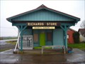 view gallery view gallerySW9.3 km |  Suver Store Suver Store
in Relocated Structures This country store was moved from the original town of Suver to Suver Junction. posted by: valsetzpegleg location: Oregon date approved: 01/05/2011 last visited: 06/20/2015 |
 view gallery view galleryN9.3 km |  The Hills Are Alive! The Hills Are Alive!
in Scenic Hikes Joryville County Park is a natural,wooded area with a stream meandering through the park at the base of the hill.Directions: 4 miles out Liberty Rd S.,then one mile West on Jory Hill Rd,then South on Elmhurst Dr a short distance to the park.
posted by: Bandmaster location: Oregon date approved: 09/19/2007 last visited: 09/12/2015 |
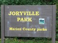 view gallery view galleryN9.3 km |  Joryville Park - Marion County, OR Joryville Park - Marion County, OR
in Municipal Parks and Plazas Joryville County Park is a natural,wooded area with a stream meandering through the park at the base of the hill.Directions: 4 miles out Liberty Rd S.,then one mile West on Jory Hill Rd,then South on Elmhurst Dr a short distance to the park.
posted by: Bandmaster location: Oregon date approved: 09/21/2007 last visited: 09/12/2015 |
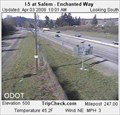 view gallery view galleryNE9.3 km |  I-5 at Enchanted Way, near Salem, Oregon I-5 at Enchanted Way, near Salem, Oregon
in Web Cameras A traffic cam visible online through the Oregon Department of Transportation website. Do not stop on the freeway for this waymark! posted by: shadow101 location: Oregon date approved: 04/03/2008 last visited: 04/03/2008 |
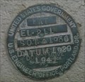 view gallery view galleryW9.3 km | FAT 1929 1938 1941 in U.S. Benchmarks I was searching for S214 (from NGS database) when I came across this benchmark in the footing of a bridge across the Luckiamute River. posted by: MIG2 location: Oregon date approved: 11/07/2011 last visited: never |
 view gallery view gallery S9.5 km S9.5 km
| Miller Cemetery - near Millersburg, Oregon in Worldwide Cemeteries One of Oregon's original cemeteries. posted by: shadow101 location: Oregon date approved: 05/23/2012 last visited: 05/18/2012 |
 view gallery view galleryW9.5 km | EDD 1941 in U.S. Benchmarks A benchmark I came across while searching for a benchmark that's on the NGS list. posted by: MIG2 location: Oregon date approved: 11/13/2011 last visited: never |
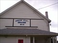 view gallery view gallerySE9.5 km |  Morning Star Grange #311 - Millersburg, Oregon Morning Star Grange #311 - Millersburg, Oregon
in Grange Halls Larger hall has had several additions through the years. posted by: shadow101 location: Oregon date approved: 06/09/2009 last visited: 10/25/2011 |
 view gallery view gallery NW9.5 km NW9.5 km
|  Independence, Oregon Independence, Oregon
in City and Town Halls Independence, Oregon's new Civic Center with City Hall and police station. posted by: valsetzpegleg location: Oregon date approved: 05/21/2015 last visited: never |
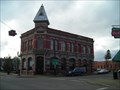 view gallery view galleryNW9.8 km | Independence National Bank - Independence, Oregon in U.S. National Register of Historic Places Still a bank after all these years! posted by: valsetzpegleg location: Oregon date approved: 01/29/2011 last visited: never |
 view gallery view galleryNW9.8 km | Cinema - Independence, Oregon in Neon Signs The local multiplex has a nice, large neon above the entrance. posted by: shadow101 location: Oregon date approved: 05/18/2013 last visited: 05/17/2013 |
 view gallery view galleryNW9.8 km |  Elvis Presley - Independence, Oregon Elvis Presley - Independence, Oregon
in Musician Statues Statues of The King and Marilyn Monroe guard the entrance to the local cineplex. posted by: shadow101 location: Oregon date approved: 05/25/2013 last visited: 05/17/2013 |
|