 view gallery view gallery SW9.5 km SW9.5 km
|   Mio Hydroelectric Plant/ Hydroelectric Power Mio Hydroelectric Plant/ Hydroelectric Power
in Michigan Historical Markers Mio Hydro Electric Plant is located at Route No. 1, Pond Drive at the Au Sable River. Mio, Mi. posted by:  Jagman714 Jagman714 location: Michigan date approved: 11/18/2006 last visited: 09/26/2021 |
 view gallery view gallerySW9.7 km |  Mio Dam end of Au Sable River - Mio, Michigan Mio Dam end of Au Sable River - Mio, Michigan
in National Wild and Scenic Rivers The Au Sable River is a designated National Wild and Scenic River Between the Mio Dam and the Alcona Pond. posted by: GT.US location: Michigan date approved: 07/08/2011 last visited: 09/26/2021 |
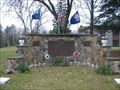
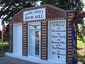 view gallery view gallerySW10.6 km |  Oscoda County Honor Roll - Mio, MI Oscoda County Honor Roll - Mio, MI
in Non-Specific Veteran Memorials Oscoda County Honor Roll located in Mio, Michigan. posted by:  Team B Squared Team B Squared location: Michigan date approved: 01/28/2009 last visited: 09/26/2021 |
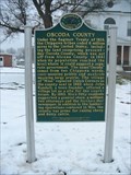 view gallery view gallerySW10.6 km | Oscoda County /Oscoda County Courthouse in Michigan Historical Markers Oscoda County /Oscoda County Courthouse is located at 311 S. Morenci Ave. Mio, Oscoda County, Mi. posted by: Jagman714 location: Michigan date approved: 11/18/2006 last visited: 07/07/2014 |
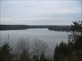 view gallery view gallerySW11.4 km |  Mio Scenic Overlook Mio Scenic Overlook
in Scenic Overlooks The Mio Scenic Overlook is off of U.S. 72 in Mio, Mi. posted by: Jagman714 location: Michigan date approved: 11/18/2006 last visited: 11/24/2006 |
 view gallery view gallery NW20.1 km NW20.1 km
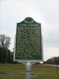
| Camp Lunden in Michigan Historical Markers The Camp Lunden Marker is Located in lewiston,Mi. posted by: Jagman714 location: Michigan date approved: 10/22/2006 last visited: 07/07/2014 |
 view gallery view galleryNW20.1 km |  Camp Lunden Camp Lunden
in Civilian Conservation Corps Camp Lunden was located in Lewiston,Mi. posted by: Jagman714 location: Michigan date approved: 10/22/2006 last visited: 05/08/2010 |
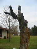 view gallery view galleryNW26.2 km |  Lewiston Bald Eagles Lewiston Bald Eagles
in Outside Wooden Display Carvings Lewiston Bald Eagles are located in Lewiston,Mi. posted by: Jagman714 location: Michigan date approved: 11/18/2006 last visited: 11/24/2009 |
 view gallery view galleryNW26.7 km |  Lewiston Church of Christ Time Capsule Lewiston Church of Christ Time Capsule
in Time Capsules Lewiston Church of Christ is located at Kneeland and Woodfield st's in Lewiston,Mi. posted by: Jagman714 location: Michigan date approved: 10/22/2006 last visited: 10/22/2006 |
 view gallery view galleryNW26.7 km | Congregational United Church of Christ in Michigan Historical Markers Lewiston Church of Christ is located in Lewiston, Mi. posted by: Jagman714 location: Michigan date approved: 10/22/2006 last visited: 07/07/2014 |
 view gallery view galleryNW27 km |  Lewiston Getaway Quonset Hut Lewiston Getaway Quonset Hut
in Quonset Huts Lewiston Getaway Hut Is a summer home in Lewiston ,Mi. posted by: Jagman714 location: Michigan date approved: 11/18/2006 last visited: 11/24/2009 |
 view gallery view gallery SE28.2 km SE28.2 km
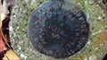
|  Alcona County, Aldrich Road area Federal Land Office Survey(.BADGER) Alcona County, Aldrich Road area Federal Land Office Survey(.BADGER)
in Public Land Survey Marks Survey marker near horse trail .
I call it BADGER area because of the numerous Badger digs and sightings in this area.(LOTS of porcupines here, too...watch out for your dogs!) posted by: cachevista location: Michigan date approved: 10/12/2010 last visited: never |
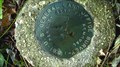
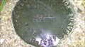
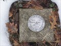
 view gallery view gallerySE28.3 km | Michaud Road Survey Marker(Federal Land Office Survey) in Public Land Survey Marks Federal Land Office Survey Marker.
Notation is "Federal Land office Survey" 1931
then 1/4 and S-28/S-38 posted by: cachevista location: Michigan date approved: 10/12/2010 last visited: 10/11/2010 |
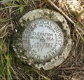
 view gallery view gallerySE28.8 km | Michaud road Section Corner Marker(Federal Land Office Survey) in Public Land Survey Marks Federal Land office Survey marker denoting section corners for sections 28-27/33-34 in T25N R5-E in Michigan! posted by: cachevista location: Michigan date approved: 10/18/2010 last visited: never |
 view gallery view galleryNW30.1 km |  139 RC 1953 139 RC 1953
in U.S. Benchmarks USGS Bench Mark located near McCormick Lake between Atlanta and Lewiston in southwestern Montmorency County. posted by: Cuchillo location: Michigan date approved: 08/19/2009 last visited: never |
 view gallery view gallery N30.6 km N30.6 km
|  N45 W84 Avery Twp, MI N45 W84 Avery Twp, MI
in Confluence Spots A bit out in the woods. posted by: jriddell location: Michigan date approved: 09/10/2006 last visited: 08/09/2003 |
 view gallery view gallerySE30.9 km | USDI - 58 WPR 1965 in U.S. Benchmarks U.S. Department of Interior triangulation disc set in top of concrete monument posted by: Tom n Chris location: Michigan date approved: 01/16/2006 last visited: 09/15/2011 |
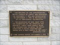
 view gallery view galleryN31.7 km |  Montmorency Honor Roll for World War II Montmorency Honor Roll for World War II
in World War II Memorials / Monuments Montmorency Honor Roll for World War II Memorial is located in front of the County buildings in the city of Atlanta, Mi. posted by: Jagman714 location: Michigan date approved: 11/19/2006 last visited: 11/14/2009 |
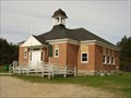 view gallery view gallery S33 km S33 km
| Rose Township District No. 5 School in Michigan Historical Markers Located on the east side of Cherry Street, between Penn and Malone Streets. Streetside parking is available. posted by: S5280ft location: Michigan date approved: 05/28/2007 last visited: 07/07/2014 |
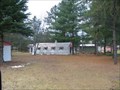
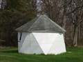 view gallery view galleryS33 km |  Geodesic Storage Shed - Lupton, MI Geodesic Storage Shed - Lupton, MI
in Odd-Shaped Buildings Located in a private residence on Ash Street in Lupton. Best viewed from the old Rose Township District No. 5 Schoolhouse on Cherry Street, between Penn and Malone Streets. posted by: S5280ft location: Michigan date approved: 05/29/2007 last visited: never |
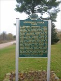 view gallery view galleryNW33.2 km | Angusdale Stock Farm in Michigan Historical Markers The Angusdale Stock Farm marker is located at 8391 Buttles Rd. Vienna Twp., Mi. posted by: Jagman714 location: Michigan date approved: 10/22/2006 last visited: 07/07/2014 |
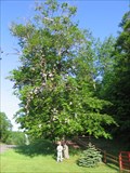 view gallery view galleryN33.2 km |  Atlanta, Michigan Shoe Tree Atlanta, Michigan Shoe Tree
in Shoe Trees Shoe tree located just west of Atlanta, Michigan. posted by: Team B Squared location: Michigan date approved: 01/21/2009 last visited: 10/14/2017 |
 view gallery view galleryN33.3 km |  The Elk Capital of Michgan - Atlanta, Michigan The Elk Capital of Michgan - Atlanta, Michigan
in Welcome Signs This sign welcomes you to Atlanta, "The Elk Capital of Michigan" as well as lets you know when the annual Elk Festival is held in this small town centered on M-32 and M-33 in Michigan. posted by: Team Cloverfrogs location: Michigan date approved: 07/31/2009 last visited: 11/20/2009 |
 view gallery view galleryN33.3 km | Atlanta, Michigan in Small Town, Big Name This is a small community located at the junction of M-32/M-33 in Michigan, USA. posted by: Team Cloverfrogs location: Michigan date approved: 08/01/2009 last visited: never |
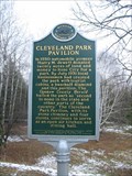 view gallery view galleryS34 km | Cleveland Park Pavilion in Michigan Historical Markers Cleveland Park Pavilion is located in Rose City, Mi. posted by: Jagman714 location: Michigan date approved: 11/18/2006 last visited: 02/13/2022 |
|