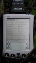
 view gallery view gallery W20.6 km W20.6 km
|   Mio Dam end of Au Sable River - Mio, Michigan Mio Dam end of Au Sable River - Mio, Michigan
in National Wild and Scenic Rivers The Au Sable River is a designated National Wild and Scenic River Between the Mio Dam and the Alcona Pond. posted by:  GT.US GT.US location: Michigan date approved: 07/08/2011 last visited: 09/26/2021 |
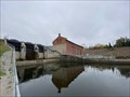
 view gallery view galleryW20.8 km |  Mio Hydroelectric Plant/ Hydroelectric Power Mio Hydroelectric Plant/ Hydroelectric Power
in Michigan Historical Markers Mio Hydro Electric Plant is located at Route No. 1, Pond Drive at the Au Sable River. Mio, Mi. posted by: Jagman714 location: Michigan date approved: 11/18/2006 last visited: 09/26/2021 |
 view gallery view gallery SW21.2 km SW21.2 km
|  Oscoda County Honor Roll - Mio, MI Oscoda County Honor Roll - Mio, MI
in Non-Specific Veteran Memorials Oscoda County Honor Roll located in Mio, Michigan. posted by:  Team B Squared Team B Squared location: Michigan date approved: 01/28/2009 last visited: 09/26/2021 |
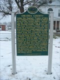 view gallery view gallerySW21.2 km | Oscoda County /Oscoda County Courthouse in Michigan Historical Markers Oscoda County /Oscoda County Courthouse is located at 311 S. Morenci Ave. Mio, Oscoda County, Mi. posted by: Jagman714 location: Michigan date approved: 11/18/2006 last visited: 07/07/2014 |
 view gallery view gallery S21.9 km S21.9 km
|  Alcona County, Aldrich Road area Federal Land Office Survey(.BADGER) Alcona County, Aldrich Road area Federal Land Office Survey(.BADGER)
in Public Land Survey Marks Survey marker near horse trail .
I call it BADGER area because of the numerous Badger digs and sightings in this area.(LOTS of porcupines here, too...watch out for your dogs!) posted by: cachevista location: Michigan date approved: 10/12/2010 last visited: never |
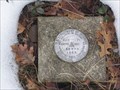
 view gallery view galleryS22.5 km | Michaud Road Survey Marker(Federal Land Office Survey) in Public Land Survey Marks Federal Land Office Survey Marker.
Notation is "Federal Land office Survey" 1931
then 1/4 and S-28/S-38 posted by: cachevista location: Michigan date approved: 10/12/2010 last visited: 10/11/2010 |
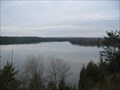 view gallery view galleryW22.5 km |  Mio Scenic Overlook Mio Scenic Overlook
in Scenic Overlooks The Mio Scenic Overlook is off of U.S. 72 in Mio, Mi. posted by: Jagman714 location: Michigan date approved: 11/18/2006 last visited: 11/24/2006 |
 view gallery view galleryS22.7 km | Michaud road Section Corner Marker(Federal Land Office Survey) in Public Land Survey Marks Federal Land office Survey marker denoting section corners for sections 28-27/33-34 in T25N R5-E in Michigan! posted by: cachevista location: Michigan date approved: 10/18/2010 last visited: never |
 view gallery view galleryS26.7 km |  USDI - 58 WPR 1965 USDI - 58 WPR 1965
in U.S. Benchmarks U.S. Department of Interior triangulation disc set in top of concrete monument posted by: Tom n Chris location: Michigan date approved: 01/16/2006 last visited: 09/15/2011 |
 view gallery view gallery NW29.5 km NW29.5 km
|  Camp Lunden Camp Lunden
in Civilian Conservation Corps Camp Lunden was located in Lewiston,Mi. posted by: Jagman714 location: Michigan date approved: 10/22/2006 last visited: 05/08/2010 |
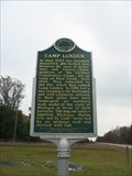 view gallery view galleryNW29.5 km | Camp Lunden in Michigan Historical Markers The Camp Lunden Marker is Located in lewiston,Mi. posted by: Jagman714 location: Michigan date approved: 10/22/2006 last visited: 07/07/2014 |
 view gallery view gallery N32 km N32 km
|  N45 W84 Avery Twp, MI N45 W84 Avery Twp, MI
in Confluence Spots A bit out in the woods. posted by: jriddell location: Michigan date approved: 09/10/2006 last visited: 08/09/2003 |
 view gallery view gallery SE34 km SE34 km
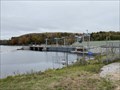
|  Five Channels Dam - Oscoda Township, MI Five Channels Dam - Oscoda Township, MI
in Wikipedia Entries Five Channels Dam is a hydro-electric dam on the Au Sable River in Oscoda Township, Michigan. posted by: bobfrapples8 location: Michigan date approved: 12/28/2021 last visited: never |
 view gallery view gallerySE34.1 km | Five Channels Dam Workers Camp / Hydroelectric Power in Michigan Historical Markers Follow the signs for the Loud Dam to get to Old M65. If you follow the signs for the Five Channels Dam, you'll end up on the wrong side of the river, since the old bridge is closed. Parking is available. posted by: S5280ft location: Michigan date approved: 05/28/2007 last visited: 10/27/2021 |
 view gallery view galleryS34.3 km |  Geodesic Storage Shed - Lupton, MI Geodesic Storage Shed - Lupton, MI
in Odd-Shaped Buildings Located in a private residence on Ash Street in Lupton. Best viewed from the old Rose Township District No. 5 Schoolhouse on Cherry Street, between Penn and Malone Streets. posted by: S5280ft location: Michigan date approved: 05/29/2007 last visited: never |
 view gallery view galleryS34.3 km | Rose Township District No. 5 School in Michigan Historical Markers Located on the east side of Cherry Street, between Penn and Malone Streets. Streetside parking is available. posted by: S5280ft location: Michigan date approved: 05/28/2007 last visited: 07/07/2014 |
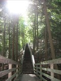 view gallery view gallerySE35.2 km |  Iargo Springs Stairway - Iosco County, MI Iargo Springs Stairway - Iosco County, MI
in Outdoor Stairways 300 downward steps to a boardwalk among some beautiful natural springs posted by: Dinoprophet location: Michigan date approved: 09/14/2009 last visited: 10/16/2011 |
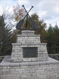 view gallery view gallerySE36.9 km |  Au Sable Canoer's Monument Au Sable Canoer's Monument
in Maritime Monuments and Memorials This monument was erected to honor the members of the Michigan Canoe Racing Association and is sited on a scenic overlook adjacent to the Au Sable river. posted by: 3inaTree location: Michigan date approved: 10/19/2011 last visited: 10/27/2021 |
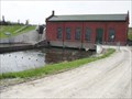
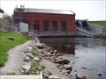
 view gallery view gallerySE37.2 km |  Cooke Hydroelectric Plant - Oscoda Township, Iosco County, Michigan, USA Cooke Hydroelectric Plant - Oscoda Township, Iosco County, Michigan, USA
in Hydroelectric Power Stations Cooke Dam is a hydro-electric dam on the Au Sable River in Michigan. It was listed on the National Register of Historic Places in August 2, 1996 as the Cooke Hydroelectric Plant. posted by: bobfrapples8 location: Michigan date approved: 12/29/2021 last visited: never |
 view gallery view gallerySE37.2 km | Cooke Dam - Oscoda Township, MI in Wikipedia Entries Cooke Dam is a hydroelectric dam located on the Au Sable River in Oscoda Township, MI. posted by: bobfrapples8 location: Michigan date approved: 12/28/2021 last visited: never |
 view gallery view gallerySE37.3 km | Cooke Hydroelectric Plant / Hydroelectric Power in Michigan Historical Markers Located at the end of Cooke Dam Road, which is pretty dammed crooked. There is parking available. posted by: S5280ft location: Michigan date approved: 05/29/2007 last visited: 10/27/2021 |
 view gallery view gallery E37.5 km E37.5 km
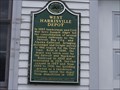
| West Harrisville Depot in Michigan Historical Markers Located on Fiske and Lake Steets posted by: Historic Markers location: Michigan date approved: 04/29/2015 last visited: 04/30/2015 |
 view gallery view galleryNW37.5 km |  Lewiston Bald Eagles Lewiston Bald Eagles
in Outside Wooden Display Carvings Lewiston Bald Eagles are located in Lewiston,Mi. posted by: Jagman714 location: Michigan date approved: 11/18/2006 last visited: 11/24/2009 |
 view gallery view galleryNW37.7 km |  Montmorency Honor Roll for World War II Montmorency Honor Roll for World War II
in World War II Memorials / Monuments Montmorency Honor Roll for World War II Memorial is located in front of the County buildings in the city of Atlanta, Mi. posted by: Jagman714 location: Michigan date approved: 11/19/2006 last visited: 11/14/2009 |
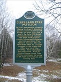 view gallery view gallerySW37.8 km | Cleveland Park Pavilion in Michigan Historical Markers Cleveland Park Pavilion is located in Rose City, Mi. posted by: Jagman714 location: Michigan date approved: 11/18/2006 last visited: 02/13/2022 |
|