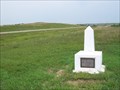
 view gallery view gallery SE41.8 km SE41.8 km
|   Plum Creek Station, Hayes, South Dakota Plum Creek Station, Hayes, South Dakota
in South Dakota Historical Markers A small concrete marker just off the US14/SD63 highway between Midland, SD, and Hayes, SD. Elevation 2067 posted by:  NGComets NGComets location: South Dakota date approved: 10/08/2013 last visited: 11/17/2022 |
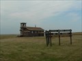 view gallery view gallerySE42.6 km |  Little Brown Church on the Prairie -- United Methodist - SD Little Brown Church on the Prairie -- United Methodist - SD
in Country Churches This small church jutting up from the flat prairie is located along US Hwy 14, 3 Mi. W. of Hayes, SD posted by: plainsdrifter358 location: South Dakota date approved: 07/28/2007 last visited: 07/17/2007 |
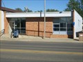
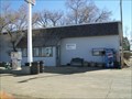 view gallery view gallery W43.8 km W43.8 km
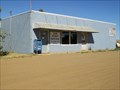
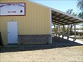
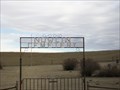
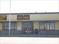
|  Howes, South Dakota 57748 Howes, South Dakota 57748
in U.S. Post Offices Combination store and post office. posted by: NGComets location: South Dakota date approved: 04/06/2011 last visited: never |
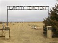 view gallery view gallery N45.1 km N45.1 km
|  Lantry Cemetery, Lantry, South Dakota Lantry Cemetery, Lantry, South Dakota
in Worldwide Cemeteries Small community cemetery just south of Lantry with about 90 graves. posted by: NGComets location: South Dakota date approved: 03/25/2013 last visited: never |
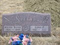 view gallery view galleryN45.1 km |  100 - Lena F. Speker 100 - Lena F. Speker
in Headstones of Centenarians Many events were seen by the lady. posted by: NGComets location: South Dakota date approved: 11/05/2012 last visited: never |
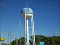
 view gallery view galleryN46 km | Lantry, South Dakota 57636 in U.S. Post Offices Small town post office. posted by: NGComets location: South Dakota date approved: 09/17/2012 last visited: never |
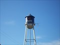
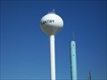 view gallery view galleryN46.7 km |  Watertower, Lantry, South Dakota Watertower, Lantry, South Dakota
in Water Towers A modern watertower north of Lantry, SD. posted by: NGComets location: South Dakota date approved: 09/12/2012 last visited: never |
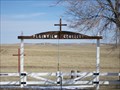
 view gallery view gallery NE48.1 km NE48.1 km
| Tasunka Masa ~ Iron Horse in South Dakota Historical Markers Chicago Milwaukee & St. Paul Railroad Depot in Eagle Butte, SD on the Cheyenne River Sioux Indian Reservation. posted by: plainsdrifter358 location: South Dakota date approved: 07/23/2007 last visited: 07/17/2007 |
 view gallery view galleryNE48.1 km | Eagle Butte, South Dakota 57625 in U.S. Post Offices Small town post office. posted by: NGComets location: South Dakota date approved: 09/17/2012 last visited: never |
 view gallery view galleryW48.4 km | Plainview Cemetery, Plainview, South Dakota in Worldwide Cemeteries Cemetery for an abandoned town with about 50 graves in it. posted by: NGComets location: South Dakota date approved: 04/08/2011 last visited: never |
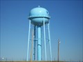
 view gallery view galleryNE49.1 km | Watertower, Eagle Butte, South Dakota in Water Towers One of 5 watertowers in this small town. posted by: NGComets location: South Dakota date approved: 09/12/2012 last visited: never |
 view gallery view galleryNE49.2 km | Eagle Butte Cemetery, Eagle Butte, South Dakota in Worldwide Cemeteries A large cemetery northwest of town with about 1,200 graves in it. posted by: NGComets location: South Dakota date approved: 09/14/2012 last visited: 06/16/2013 |
 view gallery view galleryN49.6 km | Watertower, Dupree, South Dakota in Water Towers Small town watertower. posted by: NGComets location: South Dakota date approved: 04/06/2011 last visited: never |
 view gallery view galleryN49.7 km | Dupree, South Dakota 57623 in U.S. Post Offices Small town post office. posted by: NGComets location: South Dakota date approved: 04/06/2011 last visited: never |
 view gallery view galleryNE56.3 km | Watertower, Parade, South Dakota in Water Towers A modern watertower, it stands out in contrast to the stark prairie. posted by: NGComets location: South Dakota date approved: 09/16/2012 last visited: never |
 view gallery view gallery NW59.7 km NW59.7 km
|  North Shore Golf Course, Faith, South Dakota North Shore Golf Course, Faith, South Dakota
in Public and Private Golf Courses Small golf course with sand greens, opened in 1940. posted by: NGComets location: South Dakota date approved: 09/11/2012 last visited: never |
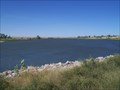 view gallery view galleryNW59.7 km |  Durkee Lake, Meade County, South Dakota Durkee Lake, Meade County, South Dakota
in Natural Lakes A small lake about 3 miles south of Faith, SD. posted by: NGComets location: South Dakota date approved: 09/11/2012 last visited: 07/08/2018 |
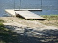 view gallery view galleryNW60.4 km |  Durkee Lake Boat Ramp, Faith, South Dakota Durkee Lake Boat Ramp, Faith, South Dakota
in Boat Ramps Northeast part of the lake, and no fee for usage. Available all hours. posted by: NGComets location: South Dakota date approved: 09/11/2012 last visited: never |
 view gallery view galleryNW61.3 km | Faith Cemetery, Faith, South Dakota in Worldwide Cemeteries Small town cemetery east of town with about 300 graves in it. posted by: NGComets location: South Dakota date approved: 03/25/2013 last visited: never |
 view gallery view gallery S61.8 km S61.8 km
| Nowlin Cemetery, Nowlin, South Dakota in Worldwide Cemeteries About 50 graves in this small cemetery. posted by: NGComets location: South Dakota date approved: 04/06/2011 last visited: never |
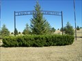
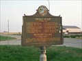
 view gallery view galleryNW62.8 km | Faith ~ End of the Cheyenne Branch of the Milwaukee Road in South Dakota Historical Markers At the end of the Cheyenne Branch of the Milwaukee Road and discovery site of 'Sue' the T-Rex and other dinosaurs, Faith is a proud cow town on the Fox Ridge Divide one half mile above sea level. posted by: plainsdrifter358 location: South Dakota date approved: 04/14/2006 last visited: 06/25/2006 |
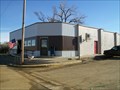
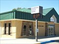 view gallery view galleryNW62.8 km |  Farmers State Bank, Faith, South Dakota Farmers State Bank, Faith, South Dakota
in Time and Temperature Signs A small bank in a small prairie town. posted by: NGComets location: South Dakota date approved: 09/11/2012 last visited: never |
 view gallery view galleryNW62.8 km | Faith, South Dakota 57626 in U.S. Post Offices Small town post office. posted by: NGComets location: South Dakota date approved: 04/07/2011 last visited: never |
 view gallery view galleryNW62.9 km | "Small Town" by Badger Clark Historic Marker in Faith, SD in South Dakota Historical Markers This Historic Marker quotes the words of Badger Clark and gives a short bio of the author. posted by: plainsdrifter358 location: South Dakota date approved: 07/23/2007 last visited: 07/16/2007 |
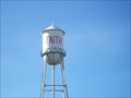 view gallery view galleryNW62.9 km | Watertower, Faith, South Dakota in Water Towers Small town watertower posted by: NGComets location: South Dakota date approved: 04/07/2011 last visited: never |
|