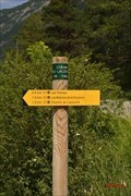
 view gallery view gallery NW7.2 km NW7.2 km
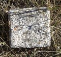
|   Repère RGF - Risoul : Le Collet Repère RGF - Risoul : Le Collet
in French Benchmarks Borne en granite gravée. Au sommet d'une colline avec vue sur la vallée de la Durance. posted by:  garenkreiz garenkreiz location: Provence-Alpes-Côte d'Azur, France date approved: 09/16/2023 last visited: 09/05/2023 |
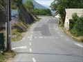 view gallery view galleryNW8.7 km |  Risoul - Guillestre, France Risoul - Guillestre, France
in Readable From Above Start of the climb of de Col de Risoul near Guillestre posted by: Becktracker location: Provence-Alpes-Côte d'Azur, France date approved: 01/10/2021 last visited: 06/29/2012 |
 view gallery view gallery SW8.7 km SW8.7 km
|  1545 m - Carrefour entre les D139A & D39T - Crévoux, Hautes Alpes, France 1545 m - Carrefour entre les D139A & D39T - Crévoux, Hautes Alpes, France
in Elevation Signs Un panneau destinés aux cyclistes durant l'ascension du Parpaillon / A sign intended for cyclists during the ascent of Parpaillon posted by: YvesProvence location: France date approved: 10/27/2023 last visited: 10/15/2023 |
 view gallery view gallerySW8.9 km |  N44.547701 E6.608169 - Crévoux Chef-lieu - Hautes Alpes, France N44.547701 E6.608169 - Crévoux Chef-lieu - Hautes Alpes, France
in Permanent Geographic Coordinates Cette altitude est présente sur un panneau à destination des randonneurs / This altitude is present on a sign intended for hikers posted by: YvesProvence location: Pennsylvania, France date approved: 10/27/2023 last visited: 10/15/2023 |
 view gallery view gallerySW8.9 km | 1570 m - Crévoux Chef-lieu - Hautes Alpes, France in Elevation Signs Cette altitude est présente sur un panneau à destination des randonneurs / This altitude is present on a sign intended for hikers posted by: YvesProvence location: Provence-Alpes-Côte d'Azur, France date approved: 10/27/2023 last visited: 10/15/2023 |
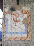
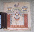 view gallery view gallery SE9 km SE9 km
|  Zarbula Sundial 1860: Petite Serennes, Ubaye, Alpes de Haute Provence Zarbula Sundial 1860: Petite Serennes, Ubaye, Alpes de Haute Provence
in Sundials In 1860 Zarbula painted a couple of sundials in the upper Ubaye valley up from Saint Paul. One is at the hamlet of Petite Serennes. posted by:  arby101ca arby101ca location: France date approved: 12/01/2009 last visited: never |
 view gallery view galleryNW10.6 km | Atelier Acacia Sundial, Mont Dauphin, France in Sundials On the west facing wall of the Atelier Acacia, is an excellent sundial constructed of glazed lava pieces by Joseph Auvray, Atelier Acacia posted by: arby101ca location: France date approved: 07/19/2010 last visited: 08/17/2010 |
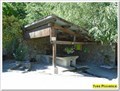
 view gallery view galleryNW10.8 km |  La source de Phazy - Les Isclasses, Paca, France La source de Phazy - Les Isclasses, Paca, France
in Hot Springs La Source d'eau chaude de Phazy, au hameau des Isclasses posted by: YvesProvence location: Provence-Alpes-Côte d'Azur, France date approved: 07/18/2017 last visited: 11/10/2017 |
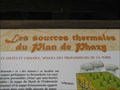 view gallery view galleryNW10.8 km |  La source de Phazy - Les Isclasses, Paca, France La source de Phazy - Les Isclasses, Paca, France
in Spas, Hammams, Mineral Baths and Saunas La Source d'eau chaude de Phazy, au hameau des Isclasses posted by: YvesProvence location: Provence-Alpes-Côte d'Azur, France date approved: 07/18/2017 last visited: 11/10/2017 |
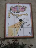
 view gallery view gallery E11.1 km E11.1 km
| Zarbula Sundial 1860 Maljasset, Ubaye, Alpes de Haute Provence, France in Sundials High in the upper Ubaye valley, at the hamlet of Maljasset, Zarbula painted a remarkable sundial in 1860. posted by: arby101ca location: France date approved: 12/01/2009 last visited: never |
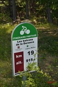 view gallery view gallery W11.4 km W11.4 km
| 915 m- Les balcons de la Durance- Siguret- Hautes Alpes- PACA- France. in Elevation Signs FR: Un panneau destinés aux cyclistes effectuant "les balcons de la Durance" .
EN: A sign intended for cyclists performing "balconies of the Durance". posted by: SISABIEL location: Provence-Alpes-Côte d'Azur, France date approved: 06/25/2018 last visited: never |
 view gallery view galleryNW11.6 km |  Borne Eborn de Saint Clément sur Durance - Saint Clément sur Durance, France Borne Eborn de Saint Clément sur Durance - Saint Clément sur Durance, France
in Electric Car Charging Stations Une Eborn du réseau Syme05. An Eborn from the Syme05 network. posted by: YvesProvence location: Provence-Alpes-Côte d'Azur, France date approved: 08/29/2020 last visited: 08/30/2020 |
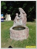 view gallery view galleryNW11.6 km |  La fontaine de la femme et l'enfant - Saint Clément sur Durance, France La fontaine de la femme et l'enfant - Saint Clément sur Durance, France
in Fountains Une fontaine sur une aire de repos de la N94 / A fountain on a rest area of the N94 posted by: YvesProvence location: Provence-Alpes-Côte d'Azur, France date approved: 08/30/2020 last visited: 08/30/2020 |
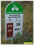 view gallery view galleryNW11.7 km | 885 m - Les Balcons de la Durance - Saint Clément sur Durance, France in Elevation Signs Un panneau d'information en bordure d'une boucle cycliste. An information panel at the edge of a cycling loop. posted by: YvesProvence location: Provence-Alpes-Côte d'Azur, France date approved: 08/29/2020 last visited: 08/30/2020 |
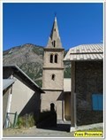 view gallery view galleryNW11.7 km |  Clocher de l'église Saint Clément - Saint Clément sur Durance Clocher de l'église Saint Clément - Saint Clément sur Durance
in Bell Towers Le clocher de l'église de Saint Clément sur Durance. The bell tower of the church of Saint Clément sur Durance. posted by: YvesProvence location: Provence-Alpes-Côte d'Azur, France date approved: 08/29/2020 last visited: 08/30/2020 |
 view gallery view galleryNW11.7 km | ") La fontaine-lavoir de Saint Clément sur Durance - Saint Clément sur Durance La fontaine-lavoir de Saint Clément sur Durance - Saint Clément sur Durance
in Lavoir (wash houses) La fontaine lavoir près de l'église paroissiale. The washhouse fountain near the parish church. posted by: YvesProvence location: Provence-Alpes-Côte d'Azur, France date approved: 08/29/2020 last visited: 08/29/2020 |
 view gallery view galleryNW11.7 km | Le lavoir de Fontvieille - Saint Clément sur Durance, France in Lavoir (wash houses) Le lavoir de fontvieille / The wash house of fontvieille posted by: YvesProvence location: Provence-Alpes-Côte d'Azur, France date approved: 08/29/2020 last visited: never |
 view gallery view galleryNW11.7 km |  Eglise Saint Clément - Saint Clément sur Durance, France Eglise Saint Clément - Saint Clément sur Durance, France
in This Old Church L'église paroissiale du village. The parish church of the village. posted by: YvesProvence location: Provence-Alpes-Côte d'Azur, France date approved: 08/29/2020 last visited: 08/30/2020 |
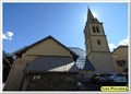 view gallery view galleryNW11.7 km | Eglise Saint Clément - Saint Clément sur Durance, France in Roman Catholic Churches L'église paroissiale du village. The parish church of the village. posted by: YvesProvence location: Provence-Alpes-Côte d'Azur, France date approved: 08/29/2020 last visited: 08/30/2020 |
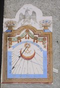
 view gallery view galleryNW11.7 km | Zarbula Sundial 1861: Le Cros, Eygliere, France in Sundials A sundial painted by Zarbula in 1861 on the corner of an old farm house in le Cros, Eygliere posted by: arby101ca location: France date approved: 11/16/2009 last visited: never |
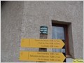
 view gallery view galleryNW11.7 km |  Vous êtes ici - Saint Clément sur Durance, France Vous êtes ici - Saint Clément sur Durance, France
in 'You Are Here' Maps Un plan de randonnée. A hiking plan. posted by: YvesProvence location: Provence-Alpes-Côte d'Azur, France date approved: 08/29/2020 last visited: never |
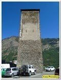 view gallery view galleryNW11.7 km |  La Tour Sarrasine - Saint Clément sur Durance, France La Tour Sarrasine - Saint Clément sur Durance, France
in Look-Out Towers La Tour Sarrasine de Saint Clément sur Durance / The Saracen Tower of Saint Clément sur Durance posted by: YvesProvence location: Provence-Alpes-Côte d'Azur, France date approved: 08/29/2020 last visited: 08/30/2020 |
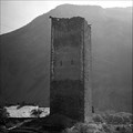 view gallery view galleryNW11.7 km |  La Tour Sarrazine - Saint Clément sur Durance, France La Tour Sarrazine - Saint Clément sur Durance, France
in Photos Then and Now La Tour Sarrasine de Saint Clément sur Durance / The Saracen Tower of Saint Clément sur Durance posted by: YvesProvence location: Provence-Alpes-Côte d'Azur, France date approved: 08/30/2020 last visited: 08/31/2020 |
 view gallery view galleryW11.9 km | 1060 m- Chemin du Lauzerot- Siguret- Hautes Alpes- PACA- France in Elevation Signs FR: Panneau indicateur pour les randonneurs. EN: Signpost for hikers. posted by: SISABIEL location: Provence-Alpes-Côte d'Azur, France date approved: 06/20/2018 last visited: never |
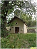 view gallery view galleryW13.4 km | Chapelle de la Gardiole - Saint André d'Embrun, PACA, France in Roman Catholic Churches La chapelle de la Gardiole à Saint André d'Embrun, Hautes, Alpes, France. posted by: YvesProvence location: Provence-Alpes-Côte d'Azur, France date approved: 10/27/2023 last visited: 10/15/2023 |
|