 view gallery view gallery NW7.9 km NW7.9 km
|   U.S. Route 1 - Sullivan, ME U.S. Route 1 - Sullivan, ME
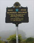
in Blue Star Memorial Highway Markers This sign is located along the Schoodic National Scenic Byway, along a rest stop. posted by:  NorStar NorStar location: Maine date approved: 10/15/2015 last visited: 06/26/2018 |
 view gallery view galleryNW7.9 km |  Paul Dudley Sargent Grave - Sullivan, ME Paul Dudley Sargent Grave - Sullivan, ME
in Worldwide Cemeteries This grave by a turnoff off U.S. Route 1 is for a former American Revolutionary War veteran who settled here after the war. posted by: NorStar location: Maine date approved: 12/27/2015 last visited: 06/26/2018 |
 view gallery view galleryNW7.9 km |  Col. Paul Dudley Sargent - Sullivan, ME Col. Paul Dudley Sargent - Sullivan, ME
in American Revolutionary War Veteran Graves Col. Paul Dudley Sargent may have helped plan the Boston Tea Party, fought in the war under General George Washington, and retired here in Sullivan and became the first county justice and probate judge in the area. posted by: NorStar location: Maine date approved: 01/11/2016 last visited: 06/26/2018 |
 view gallery view galleryNW7.9 km |  Paul Dudley Sargent - Sullivan, ME Paul Dudley Sargent - Sullivan, ME
in Out of Place Graves This grave by a turnoff off U.S. Route 1 is for a former American Revolutionary War veteran who settled here after the war. posted by: NorStar location: Maine date approved: 01/03/2016 last visited: 06/26/2018 |
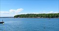
 view gallery view galleryNW8.9 km |  Tidal Falls Preserve, Frenchman Bay Conservancy - Hancock, ME Tidal Falls Preserve, Frenchman Bay Conservancy - Hancock, ME
in Public Access Lands The preserve is a nice place to look at the tidal falls at a narrow point of the Taunton River and enjoy lunch at one of the tables. posted by: NorStar location: Maine date approved: 12/29/2015 last visited: never |
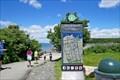
 view gallery view galleryNW10 km |  Schoodic National Scenic Byway - Hancock ME Schoodic National Scenic Byway - Hancock ME
in National Scenic Byways Located on Rt 1 at the entrance to the Schoodic National Scenic Byway posted by: nomadwillie location: Maine date approved: 09/29/2015 last visited: 06/26/2018 |
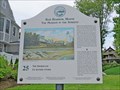
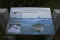 view gallery view galleryNW10 km |  Schooners Plied these Waters... Schoodic Scenic Byway Turn Off- Hancock, ME Schooners Plied these Waters... Schoodic Scenic Byway Turn Off- Hancock, ME
in Maine Historical Markers Across Taunton Bay from the sign was a granite pier where schooners landed. posted by: NorStar location: Maine date approved: 12/29/2015 last visited: 06/26/2018 |
 view gallery view galleryNW10.8 km |  MrPirateCat = 6814728 near Hancock, Maine MrPirateCat = 6814728 near Hancock, Maine
in Where's In A Name? Thanks to EMSDanel in Maine for responding to my email and providing the picture for this waymark. posted by: InGodsHands location: Maine date approved: 10/18/2010 last visited: 10/18/2010 |
 view gallery view gallery S11.1 km S11.1 km
| Schoodic National Scenic Byway - Schoodic Point/Acadia National Park - Winter Harbor, ME in National Scenic Byways The portion of the scenic byway that passes through the mainland portion of Acadia National Park, winds through pristine landscape with views of the ocean from rocky points. posted by: NorStar location: Maine date approved: 10/17/2015 last visited: 06/26/2018 |
 view gallery view gallery SW12.1 km SW12.1 km
|  Bar Harbor - Maine Bar Harbor - Maine
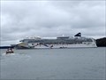
in Cruise Ship Ports Bar Harbor, ME is a tender port. Our cruise ship, the NCL Dawn, was anchored south of Bar Island and Sheep Porcupine Island. Tenders take visitors to the docks at One West Street in Bar Harbor. posted by:  neoc1 neoc1 location: Maine date approved: 05/20/2019 last visited: 07/14/2019 |
 view gallery view gallerySW12.2 km |  Bar Island - Hancock County - ME Bar Island - Hancock County - ME
in Wikipedia Entries Bar Island is a tidal island directly north of Bar Harbor, Mount Desert Island, Maine. Walking to Bar Island during low tide is a popular tourist attraction and activity. posted by:  denben denben location: Maine date approved: 10/22/2022 last visited: 07/25/2006 |
 view gallery view gallerySW12.2 km |  Bar Island - Bar Harbor - ME Bar Island - Bar Harbor - ME
in Satellite Imagery Oddities Bar Island is a tidal island directly north of Bar Harbor, Mount Desert Island, Maine. Walking to Bar Island during low tide is a popular tourist attraction and activity. posted by: denben location: Maine date approved: 11/01/2022 last visited: never |
 view gallery view gallerySW12.6 km | Margaret Todd (schooner) - Bar Harbor, ME in Wikipedia Entries Margaret Todd is a four-masted schooner sailing into Frenchman Bay from the pier at the Bar Harbor Inn in Bar Harbor, Maine. posted by: denben location: Maine date approved: 11/03/2022 last visited: never |
 view gallery view gallerySW12.6 km |  Margaret Todd - Bar Harbor, ME Margaret Todd - Bar Harbor, ME
in Scenic Boat Rides Margaret Todd is a four-masted schooner sailing into Frenchman Bay from the pier at the Bar Harbor Inn in Bar Harbor, Maine. posted by: denben location: Maine date approved: 11/02/2022 last visited: never |
 view gallery view gallerySW12.6 km |  Sailing in Acadia - Bar Harbor, ME Sailing in Acadia - Bar Harbor, ME
in Official Local Tourism Attractions Sailing on a beautiful summer day off Mount Desert Island near Acadia National Park is one of the most appealing activities for vacationers. The Margaret Todd schooner at the Bar Harbor Inn pier in Bar Harbor is a popular option. posted by: denben location: Maine date approved: 11/06/2022 last visited: never |
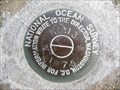
 view gallery view gallerySW12.6 km |  841 3320 TIDAL 1 - Bar Harbor, Maine 841 3320 TIDAL 1 - Bar Harbor, Maine
in U.S. Benchmarks This is a tidal benchmark disk set in the concrete bulkhead cap of the municipal pier. posted by: UMainah location: Maine date approved: 11/13/2013 last visited: 06/29/2018 |
 view gallery view gallerySW12.6 km | 841 3320 TIDAL 11 - Bar Harbor ME in U.S. Benchmarks This is a tidal benchmark set in the walkway surrounding the municipal pier parking lot in Bar Harbor, Maine. posted by: shorbird location: Maine date approved: 10/25/2013 last visited: 06/29/2018 |
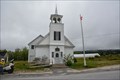 view gallery view gallery SE12.6 km SE12.6 km
|  Birch Harbor Baptist Church - Brich Habor ME Birch Harbor Baptist Church - Brich Habor ME
in This Old Church Located along RT 186 (Main St). posted by: nomadwillie location: Maine date approved: 10/01/2015 last visited: 06/26/2018 |
 view gallery view gallerySW12.6 km | 841 3320 TIDAL 13 - Bar Harbor ME in U.S. Benchmarks This is a tidal benchmark set in the concrete boat ramp at the municipal pier in Bar Harbor, Maine. posted by: shorbird location: Maine date approved: 10/25/2013 last visited: 06/29/2018 |
 view gallery view gallerySW12.6 km | Shore Path - Bar Harbor, ME in Wikipedia Entries The Shore Path extends 1.2 km along Frenchman Bay from centrally located Town's Ells Pier to Wayman Lane in Bar Harbor, Maine. A walk along the trail is a popular activity among locals and visitors. posted by: denben location: Maine date approved: 11/02/2022 last visited: never |
 view gallery view gallerySW12.6 km | Shore Path Walk- Bar Harbor, ME in Official Local Tourism Attractions The Shore Path extends 1.2 km along Frenchman Bay from centrally located Town's Ells Pier to Wayman Lane in Bar Harbor, Maine. A walk along the trail is a popular activity among locals and visitors. posted by: denben location: Maine date approved: 11/02/2022 last visited: never |
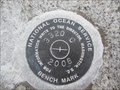 view gallery view gallerySW12.6 km | TIDAL 3320 C - Bar Harbor ME in U.S. Benchmarks This is a tidal benchmark set in the seawall in Bar Harbor, Maine. posted by: shorbird location: Maine date approved: 10/27/2013 last visited: 06/29/2018 |
 view gallery view gallerySW12.6 km | The Shorepath - Bar Harbor, ME in Maine Historical Markers The Shorepath extends 1.2 km along Frenchman Bay from centrally located Town's Ells Pier to Wayman Lane in Bar Harbor, Maine. A walk along the trail is a popular activity among locals and visitors. posted by: denben location: Maine date approved: 11/04/2022 last visited: never |
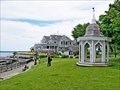
 view gallery view gallerySW12.6 km | Bar Harbor Inn - Bar Harbor, ME in Wikipedia Entries The Bar Harbor Inn in Bar Harbor, Maine was built in 1887, and has been an inn since 1950. posted by: denben location: Maine date approved: 11/03/2022 last visited: never |
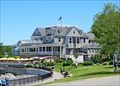 view gallery view gallerySW12.6 km |  Bar Harbor Inn - Bar Harbor, ME Bar Harbor Inn - Bar Harbor, ME
in Recommended Accommodation The Bar Harbor Inn is located at 1 Newport Drive in Bar Harbor, Maine. It was built in 1887, and has been an inn since 1950. posted by: denben location: Maine date approved: 11/10/2022 last visited: never |
|