 view gallery view gallery N14.3 km N14.3 km
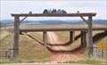
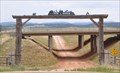
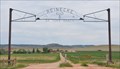
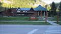
|   Ayer Ranch Entrance Arch Ayer Ranch Entrance Arch
in Freestanding Arches This Freestanding Arch is at the main entrance to the Ayer Ranch on the south side of Old Highway 14 about 2.8 miles west of Beulah, Wyoming. posted by:  brwhiz brwhiz location: Wyoming date approved: 12/17/2012 last visited: never |
 view gallery view galleryN14.3 km |  Vore Buffalo Jump - Crook County - near Sundance, WY Vore Buffalo Jump - Crook County - near Sundance, WY
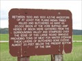
in Official Local Tourism Attractions Ancient times this was the butcher shop. Archaeological site, now open to the public. posted by: YoSam. location: Wyoming date approved: 09/28/2015 last visited: 09/12/2019 |
 view gallery view galleryN14.3 km |  Vore Buffalo Jump - Crook County - near Sundance, WY Vore Buffalo Jump - Crook County - near Sundance, WY
in U.S. National Register of Historic Places Ancient times this was the butcher shop. Archaeological site, now open to the public. posted by: YoSam. location: Wyoming date approved: 09/27/2015 last visited: 09/12/2019 |
 view gallery view galleryN14.3 km |  Vore Buffalo Jump - near Sundance, WY Vore Buffalo Jump - near Sundance, WY
in Wikipedia Entries Archaeological site, now open to the public posted by: YoSam. location: Wyoming date approved: 09/27/2015 last visited: 09/12/2019 |
 view gallery view galleryN14.5 km |  Ayer Ranch ~ Beulah, Wyoming Ayer Ranch ~ Beulah, Wyoming
in Named Farms and Ranches The Ayer Ranch is located on the south side of Old Highway 14 and Interstate Highway 90 about 2.8 miles west of Beulah, Wyoming. posted by: brwhiz location: Wyoming date approved: 04/10/2013 last visited: never |
 view gallery view galleryN14.5 km |  Buffalo Jump - near Sundance, WY Buffalo Jump - near Sundance, WY
in Wyoming Historical Markers Ancient times this was the butcher shop. posted by: YoSam. location: Wyoming date approved: 09/27/2015 last visited: never |
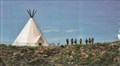
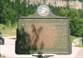
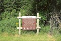
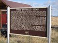 view gallery view galleryN14.5 km | Vore Buffalo Jump in Wyoming Historical Markers Plains Indians depended upon Buffalo for many of their material needs - food, shelter, clothing, tools, fuel, ceremonial objects, even toys. This is the Vore Buffalo Jump where the plains indians havested hundreds of buffalo. posted by:  stephenandcarol stephenandcarol location: Wyoming date approved: 02/22/2009 last visited: 09/12/2019 |
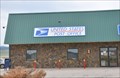 view gallery view galleryN14.6 km |  Beulah, Wyoming 82712 Beulah, Wyoming 82712
in U.S. Post Offices This Post Office is located at 5930 Old Highway 14 in Beulah, Wyoming. posted by: brwhiz location: Wyoming date approved: 01/27/2013 last visited: never |
 view gallery view galleryN14.6 km | Ox Yoke Ranch ~ Beulah, Wyoming in Named Farms and Ranches The Ox Yoke Ranch is located at 5993 Old Highway 14 east of Beulah, Wyoming. posted by: brwhiz location: Wyoming date approved: 04/10/2013 last visited: 04/23/2017 |
 view gallery view galleryN14.6 km | Ox Yoke Ranch in Freestanding Arches This Freestanding Arch is at the main entrance to the Ox Yoke Ranch at 5993 Old Highway 14 east of Beulah, Wyoming. posted by: brwhiz location: Wyoming date approved: 12/17/2012 last visited: never |
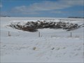 view gallery view galleryN14.6 km |  Vore Buffalo Jump Sister sinkhole - Crook County, Wyoming Vore Buffalo Jump Sister sinkhole - Crook County, Wyoming
in Natural Sinkholes The Native Americans used the sinkhole across the street to hunt buffalo by stampeding them into the sinkhole for easy butchering. This sister hole is located across the street from the historic site. posted by: onfire4jesus location: Wyoming date approved: 05/02/2013 last visited: 08/11/2017 |
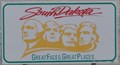 view gallery view galleryN14.6 km |  South Dakota ~ "Great Faces . Great Places" South Dakota ~ "Great Faces . Great Places"
in Welcome Signs This Welcome Sign greets you as you leave Wyoming and enter South Dakota on Interstate Highway 90 about 8 miles west of North Spearfish, South Dakota. posted by: brwhiz location: South Dakota date approved: 12/17/2012 last visited: 09/04/2019 |
 view gallery view galleryN14.6 km |  Wyoming/South Dakota, I-90 Wyoming/South Dakota, I-90
in Border Crossings This crossing is located on I-90 in the Black Hills of Wyoming and South Dakota. In the region you'll find Devils Tower, Mt. Rushmore, and many more great places to visit. posted by: Hikenutty location: Wyoming date approved: 07/09/2007 last visited: 08/24/2017 |
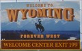 view gallery view galleryN14.6 km | Welcome to Wyoming ~ "Forever West" in Welcome Signs This Welcome Sign greets you as you leave South Dakota and enter Wyoming on Interstate Highway 90 just east of Beulah, Wyoming. posted by: brwhiz location: Wyoming date approved: 12/17/2012 last visited: 03/16/2023 |
 view gallery view gallery SE14.8 km SE14.8 km
|  CCC Camp F-18 ~ Savoy, SD CCC Camp F-18 ~ Savoy, SD
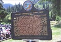
in Civilian Conservation Corps Companies: 756 (May 2, '34 to Oct 15, '34); 792 (May 15, '35 to Oct. 17, '35); 792 (Oct. '40 to July '41). posted by: YoSam. location: South Dakota date approved: 12/18/2008 last visited: 06/07/2015 |
 view gallery view gallerySE14.8 km |  Civilian Conservation Corps Camp - F-18 Savoy Civilian Conservation Corps Camp - F-18 Savoy
in South Dakota Historical Markers CCC camp Army built, to renovate forest and improve recreation. posted by: YoSam. location: South Dakota date approved: 02/22/2008 last visited: 06/07/2015 |
 view gallery view gallerySE14.8 km |  Latchstring Inn - Savoy, SD Latchstring Inn - Savoy, SD
in Independent Diners "In 1909 it was purchased by two ladies from Iowa and renamed The Latchstring, after its old latchstring-operated door that many visitors passed through." - Latchstring Restaurant posted by: YoSam. location: South Dakota date approved: 10/03/2017 last visited: 09/01/2019 |
 view gallery view gallerySE14.8 km |  '76 Trail - Savoy, SD '76 Trail - Savoy, SD
in Hiking and walking trailheads Only trail to reach the rim of the canyon posted by: YoSam. location: South Dakota date approved: 09/03/2015 last visited: never |
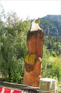 view gallery view gallerySE14.8 km |  Eagle - Savoy, SD Eagle - Savoy, SD
in Outside Wooden Display Carvings Watching people walk from the lodge, across the street and down the sidewalk to the restaurant. posted by: YoSam. location: South Dakota date approved: 10/01/2015 last visited: never |
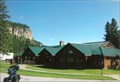
 view gallery view gallerySE14.8 km |  Spearfish Canyon Lodge - Savoy, SD Spearfish Canyon Lodge - Savoy, SD
in Lodge-Style Accommodations Lodge on one side of the road and the Latchstring Restaurant on the other. posted by: YoSam. location: South Dakota date approved: 09/30/2017 last visited: never |
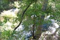
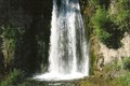
 view gallery view gallerySE14.8 km |  Spearfish Falls, Savoy, SD Spearfish Falls, Savoy, SD
in Waterfalls A easy hike if you reverse yourself and backtrack up to the restaurant, but very difficult if you continue the loop. posted by: YoSam. location: South Dakota date approved: 08/31/2015 last visited: 08/09/2021 |
 view gallery view gallerySE14.8 km |  New Trek to Spearfish Falls Completed - Savoy, SD New Trek to Spearfish Falls Completed - Savoy, SD
in News Article Locations When I visited there was a very difficult hike route, and a newer easy trail...now there is even an easier way down. posted by: YoSam. location: South Dakota date approved: 02/14/2019 last visited: 06/10/2021 |
 view gallery view gallerySE14.8 km | Spearfish Falls - Spearfish Canyon - Savoy, SD in Official Local Tourism Attractions A easy hike if you reverse yourself and backtrack up to the restaurant, but very difficult if you continue the loop. posted by: YoSam. location: South Dakota date approved: 02/14/2019 last visited: 03/16/2023 |
 view gallery view gallery NW15.3 km NW15.3 km
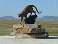
|  Cougar - Beulah - Wyoming Cougar - Beulah - Wyoming
in Figurative Public Sculpture a cougar also known as mountain lion at Welcome Center posted by: gemeloj location: Wyoming date approved: 12/19/2019 last visited: 06/04/2019 |
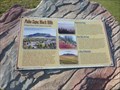 view gallery view galleryNW15.3 km |  Paha Sapa, Black Hills - near Sundance - Wyoming Paha Sapa, Black Hills - near Sundance - Wyoming
in Places of Geologic Significance Paha Sapa, Black Hills
Geologic History of the Lakotas' Sacred Hills posted by: gemeloj location: Wyoming date approved: 12/16/2019 last visited: 06/04/2019 |
|