 view gallery view gallery NE12.9 km NE12.9 km
|   Watertower, Highmore, South Dakota Watertower, Highmore, South Dakota
in Water Towers Watertower in a small town. posted by:  NGComets NGComets location: South Dakota date approved: 10/13/2009 last visited: never |
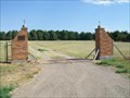
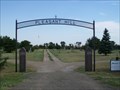
 view gallery view galleryNE13.2 km |  St. Mary's Cemetery, Highmore, South Dakota St. Mary's Cemetery, Highmore, South Dakota
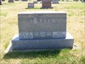
in Worldwide Cemeteries A Catholic cemetery south east of town. posted by: NGComets location: South Dakota date approved: 08/07/2012 last visited: never |
 view gallery view galleryNE13.2 km |  101 - Mae Meeker, Highmore, South Dakota 101 - Mae Meeker, Highmore, South Dakota
in Headstones of Centenarians Located in a cemetery near Highmore, SD. posted by: NGComets location: South Dakota date approved: 08/06/2012 last visited: never |
 view gallery view gallery N13.2 km N13.2 km
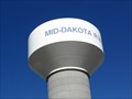
| Watertower, Middakota Rural Water System, Highmore, South Dakota in Water Towers Watertower, part of a rural system of water supply in South Dakota. posted by: NGComets location: South Dakota date approved: 10/13/2009 last visited: 10/30/2011 |
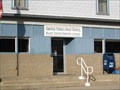
 view gallery view galleryNE13.4 km |  The Highmore Herald, Highmore, South Dakota The Highmore Herald, Highmore, South Dakota
in Newspaper Headquarters Small newspaper serving the surrounding area. Elevation 1929 posted by: NGComets location: South Dakota date approved: 05/01/2013 last visited: never |
 view gallery view galleryNE13.4 km |  The Highmore Herald / Crooked Arrow Tack Supplies, Highmore, South Dakota The Highmore Herald / Crooked Arrow Tack Supplies, Highmore, South Dakota
in Humorous Combination Businesses Strange combination of local newspaper and a horse tack supply business. Elevation 1929 posted by: NGComets location: South Dakota date approved: 05/15/2013 last visited: never |
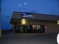
 view gallery view galleryNE13.5 km |  Highmore, South Dakota 57345 Highmore, South Dakota 57345
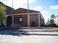
in U.S. Post Offices Small town post office. posted by: NGComets location: South Dakota date approved: 10/13/2009 last visited: never |
 view gallery view gallery NW20.8 km NW20.8 km
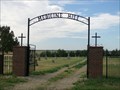
| St. John's Cemetery, Harrold, South Dakota in Worldwide Cemeteries A small Catholic cemetery southeast of town. posted by: NGComets location: South Dakota date approved: 08/07/2012 last visited: never |
 view gallery view galleryNW21.4 km | Medicine Hill Cemetery, Harrold, South Dakota in Worldwide Cemeteries A small community cemetery south of town on County Road 200. posted by: NGComets location: South Dakota date approved: 08/07/2012 last visited: never |
 view gallery view galleryNW21.6 km | Watertower, Harrold, South Dakota in Water Towers Watertower in a small town. posted by: NGComets location: South Dakota date approved: 10/13/2009 last visited: never |
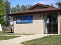
 view gallery view galleryNW21.7 km | Harrold, South Dakota 57536 in U.S. Post Offices Small town post office. posted by: NGComets location: South Dakota date approved: 10/13/2009 last visited: never |
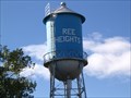 view gallery view galleryNE27.7 km | Watertower, Ree Heights, South Dakota in Water Towers Watertower in a small town. posted by: NGComets location: South Dakota date approved: 10/13/2009 last visited: never |
 view gallery view galleryNE27.7 km | Ree Heights, South Dakota 57371 in U.S. Post Offices Small town post office. posted by: NGComets location: South Dakota date approved: 10/13/2009 last visited: never |
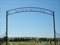 view gallery view galleryNE28.3 km | Morningside Cemetery, Ree Heights, South Dakota in Worldwide Cemeteries Located about 1/2 mile east of town with about 250 graves in it. posted by: NGComets location: South Dakota date approved: 08/07/2012 last visited: never |
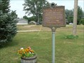
 view gallery view gallery SW34.1 km SW34.1 km
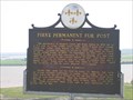
|  First Permanent Fur Post First Permanent Fur Post
in South Dakota Historical Markers The partnership of Registre Loisel and Hugh Heney in 1802 set a fur post on Cedar Island. posted by: MNSearchers location: South Dakota date approved: 05/30/2007 last visited: 05/27/2011 |
 view gallery view gallery S38.5 km S38.5 km
| Ft. Thompson, South Dakota 57339 in U.S. Post Offices Small town post office on a Reservation. posted by: NGComets location: South Dakota date approved: 05/06/2009 last visited: never |
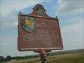
 view gallery view gallery W39.1 km W39.1 km
| Blunt, South Dakota 57522 in U.S. Post Offices Small town post office. posted by: NGComets location: South Dakota date approved: 10/13/2009 last visited: never |
 view gallery view galleryW39.4 km | Mentor Graham in South Dakota Historical Markers Mentor Graham, the man who taught Abraham Lincoln posted by: plainsdrifter358 location: South Dakota date approved: 07/24/2007 last visited: 10/30/2011 |
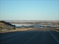 view gallery view galleryS39.6 km |  Big Bend Dam - Ft. Thompson, SD Big Bend Dam - Ft. Thompson, SD
in Water Dams Big Bend Dam located just west of Ft. Thompson, SD posted by: dbrockhouse location: South Dakota date approved: 02/25/2011 last visited: never |
 view gallery view galleryW40.1 km | You Are Now on the 100° Meridian in South Dakota Historical Markers The 100th Meridian is significant historically. posted by: plainsdrifter358 location: South Dakota date approved: 07/24/2007 last visited: 07/18/2007 |
 view gallery view galleryW41.4 km | Pleasant Hill Cemetery, Blunt, South Dakota in Worldwide Cemeteries A larger community cemetery west of town. posted by: NGComets location: South Dakota date approved: 08/07/2012 last visited: never |
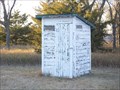 view gallery view galleryNE42.3 km |  Greenleaf Church Outhouse, Miller, South Dakota Greenleaf Church Outhouse, Miller, South Dakota
in Outhouses No indoor facilities. posted by: NGComets location: South Dakota date approved: 10/18/2012 last visited: never |
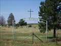
 view gallery view galleryNE42.3 km |  Greenleaf United Methodist Church, Miller, South Dakota Greenleaf United Methodist Church, Miller, South Dakota
in Methodist Churches Located near Lake Louise in Hand County. posted by: NGComets location: South Dakota date approved: 10/18/2012 last visited: never |
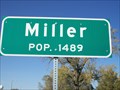 view gallery view gallery E43.3 km E43.3 km
|  Miller, South Dakota - Population 1489 Miller, South Dakota - Population 1489
in Population Signs County seat of Hand County, South Dakota. Elevation 1575 posted by: NGComets location: South Dakota date approved: 12/23/2015 last visited: never |
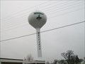 view gallery view galleryE43.5 km | Watertower, Miller, South Dakota in Water Towers New watertower in a small town. posted by: NGComets location: South Dakota date approved: 04/08/2011 last visited: 10/28/2011 |
|