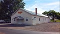
 view gallery view gallery S0.2 km S0.2 km
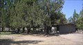
|   Terrebonne Grange #663 - Terrebonne, OR Terrebonne Grange #663 - Terrebonne, OR
in Grange Halls This grange is located at the corner of NW Smith Rock Way and NW 11th St. posted by:  NW_history_buff NW_history_buff location: Oregon date approved: 08/10/2015 last visited: never |
 view gallery view galleryS0.3 km |  Terrebone, OR 97760 ~ Main Post Office Terrebone, OR 97760 ~ Main Post Office
in U.S. Post Offices The Terrebonne, OR Post Office. posted by: Volcanoguy location: Oregon date approved: 02/18/2007 last visited: 05/12/2015 |
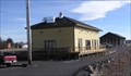 view gallery view gallery SE0.5 km SE0.5 km
|  Oregon Trunk Depot, Terrebonne, Oregon Oregon Trunk Depot, Terrebonne, Oregon
in Train Stations/Depots The old railroad station at Terrebonne, Oregon. posted by: Volcanoguy location: Oregon date approved: 03/06/2007 last visited: 05/12/2015 |
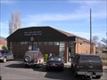
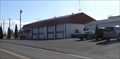 view gallery view gallery W0.5 km W0.5 km
|  Terrebonne Station (#402), Terrebonne, Oregon Terrebonne Station (#402), Terrebonne, Oregon
in Firehouses Redmond’s Terrebone Station is located on C Ave. posted by: Volcanoguy location: Oregon date approved: 02/10/2006 last visited: never |
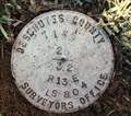
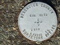 view gallery view gallerySE0.6 km |  GIS 021 - Deschutes County, OR GIS 021 - Deschutes County, OR
in U.S. Benchmarks Central Oregon Grid mark set by Deschutes County Surveyors Office in 1988 posted by: Cooke17513 location: Oregon date approved: 12/02/2011 last visited: never |
 view gallery view gallery E2.3 km E2.3 km
|  Robert Dale Maxwell Jr.-Terrebonne, OR Robert Dale Maxwell Jr.-Terrebonne, OR
in Medal Of Honor Resting Places World War II Medal of Honor Recipient for action near Besancon, France on September 7, 1944. He is buried in Terrebonne Pioneer Cemetery, Terrebonne, OR in Block 1, Lot 85E. posted by:  Don.Morfe Don.Morfe location: Oregon date approved: 10/28/2019 last visited: never |
 view gallery view gallery NE3.5 km NE3.5 km
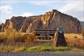
|  Smith Rock State Park - Terrebone, OR Smith Rock State Park - Terrebone, OR
in Established Rock Climbing Areas If you enjoy scenic views of deep river canyons or rock climbing, Smith Rock State Park is the place for you. posted by: dkestrel location: Oregon date approved: 02/13/2014 last visited: 07/03/2017 |
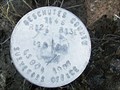
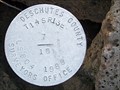 view gallery view galleryW3.5 km |  T14S R13E SECS 7 18 1/4 COR - Deschutes County, OR T14S R13E SECS 7 18 1/4 COR - Deschutes County, OR
in Public Land Survey Marks PLSS quarter corner; Deschutes County Surveyors Office cap set by C.H. Ketcham in 1988 posted by: Cooke17513 location: Oregon date approved: 12/16/2011 last visited: never |
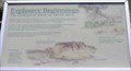 view gallery view galleryNE3.5 km |  Explosive Beginnings Explosive Beginnings
in Oregon Historical Markers Sign about the Geological Story of Smith Rock posted by: Volcanoguy location: Oregon date approved: 08/10/2006 last visited: 08/11/2006 |
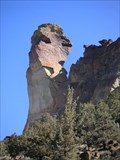 view gallery view galleryNE3.5 km |  The Monkey Face The Monkey Face
in Simulacra The Monkey Face is a rather famous landmark in the Smith Rock State Park, OR posted by: Hoo T. Owl location: Oregon date approved: 12/11/2005 last visited: 07/08/2007 |
 view gallery view gallery SW4 km SW4 km
| T14S R13E S29 32 1/4 COR - Deschutes County, OR in Public Land Survey Marks PLSS quarter corner set by Deschutes County Surveyors Office, Cornelius H. Ketcham in 1987 posted by: Cooke17513 location: Oregon date approved: 02/14/2014 last visited: never |
 view gallery view galleryW4.2 km | T14S R12E SEC 13 R13E SEC 18 1/4 COR - Deschutes County, OR in Public Land Survey Marks PLSS quarter corner and Central Oregon Grid mark, designated 14131840; Deschutes County Surveyors Office cap set by C.H. Ketcham in 1988 posted by: Cooke17513 location: Oregon date approved: 12/19/2011 last visited: never |
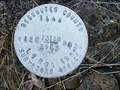 view gallery view galleryW4.2 km | T14S R12E SECS 13 24 R13E SECS 18 19 COR - Deschutes County, OR in Public Land Survey Marks PLSS section corner and Central Oregon Grid mark, designated 14131800; Deschutes County Surveyors Office cap set by C.H. Ketcham in 1988 posted by: Cooke17513 location: Oregon date approved: 12/14/2011 last visited: never |
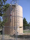 view gallery view gallery N4.3 km N4.3 km
|  Ogden Wayside Watertank - Oregon Ogden Wayside Watertank - Oregon
in Water Towers Small water tank at Peter Skene Ogden Scenic Wayside. posted by: Volcanoguy location: Oregon date approved: 08/07/2006 last visited: 06/12/2012 |
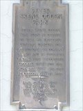
 view gallery view galleryN4.3 km | Peter Skene Ogden in Oregon Historical Markers Oregon History Sign - Peter Skene Ogden - Along U.S. Hwy. 97 posted by: Volcanoguy location: Oregon date approved: 08/06/2006 last visited: 06/21/2015 |
 view gallery view galleryN4.3 km |  Peter Skene Ogden State Scenic Viewpoint Peter Skene Ogden State Scenic Viewpoint
in 'You Are Here' Maps You are Here map at the Peter Skene Ogden State Scenic Viewpoint posted by: ddtfamily location: Oregon date approved: 09/24/2012 last visited: 06/21/2015 |
 view gallery view galleryN4.3 km |  Peter Skene Ogden State Scenic Viewpoint, Oregon Peter Skene Ogden State Scenic Viewpoint, Oregon
in Highway Rest Areas The Peter Skene Ogden Viewpoint is located at the U.S. Hwy. 97 crossing of the 300 foot deep Crooked River Gorge. posted by: Volcanoguy location: Oregon date approved: 08/07/2006 last visited: 06/21/2015 |
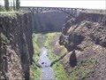 view gallery view galleryN4.3 km |  Peter Skene Ogden State Scenic Viewpoint, Oregon Peter Skene Ogden State Scenic Viewpoint, Oregon
in Scenic Roadside Look-Outs The Peter Skene Ogden Viewpoint is located at the U.S. Hwy. 97 crossing of the 300 foot deep Crooked River Gorge. posted by: Volcanoguy location: Oregon date approved: 08/07/2006 last visited: 06/21/2015 |
 view gallery view galleryN4.3 km |  Crooked River Gorge Bridge, Dechutes/Jefferson County, OR Crooked River Gorge Bridge, Dechutes/Jefferson County, OR
in Railroad Bridges The Crooked River Gorge Railroad Bridge can be view from Peter Skene Ogden Scenic Wayside. There are also two notable highway bridges nearby. posted by: Volcanoguy location: Oregon date approved: 08/06/2006 last visited: 06/21/2015 |
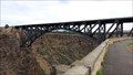
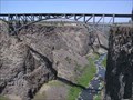 view gallery view galleryN4.5 km |  Crooked River Gorge Railroad Bridge Crooked River Gorge Railroad Bridge
in Arch Bridges The 1911, SP&S Railroad Bridge across the Crooked River Gorge. posted by: Volcanoguy location: Oregon date approved: 03/08/2009 last visited: 06/21/2015 |
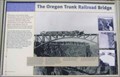 view gallery view galleryN4.5 km | The Oregon Trunk Railroad Bridge in Oregon Historical Markers The Oregon Trunk Railroad Bridge Sign at Peter Skene Ogden Scenic Wayside.
posted by: Volcanoguy location: Oregon date approved: 08/06/2006 last visited: 06/21/2015 |
 view gallery view galleryN4.5 km |  FIRST - Structure to Cross the Crooked River Gorge FIRST - Structure to Cross the Crooked River Gorge
in First of its Kind The posted coordinates place you at an interpretive display within Peter Skene Ogden State Park / Wayside which highlights this railroad bridge FIRST. posted by: NW_history_buff location: Oregon date approved: 08/10/2015 last visited: never |
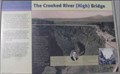 view gallery view galleryN4.5 km | The Crooked River (High) Bridge in Oregon Historical Markers The Crooked River (High) Bridge Sign at Peter Skene Ogden Scenic Wayside.
posted by: Volcanoguy location: Oregon date approved: 08/06/2006 last visited: 07/24/2016 |
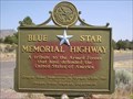 view gallery view galleryN4.5 km |  Peter Skene Ogden Scenic Wayside, Terrebonne, OR Peter Skene Ogden Scenic Wayside, Terrebonne, OR
in Blue Star Memorial Highway Markers This Blue Star Memorial Highway Marker is located in Peter Skene Ogden Scenic Wayside.
posted by: Volcanoguy location: Oregon date approved: 08/06/2006 last visited: 07/06/2019 |
 view gallery view galleryN4.5 km | Peter Skene Ogden Park (south) in Oregon Historical Markers Sign on southwest tower of old Hwy. 97 bridge. posted by: Volcanoguy location: Oregon date approved: 08/10/2006 last visited: 06/21/2015 |
|