 view gallery view gallery SW13.2 km SW13.2 km
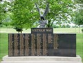
|   Vietnam War Memorial, Memorial Park, Arcadia, WI, USA Vietnam War Memorial, Memorial Park, Arcadia, WI, USA
in Vietnam War Memorials Two section Vietnam war memorial along the Soldiers Walk of the Arcadia, Wisconsin, Memorial Park. posted by:  HANSENNI HANSENNI location: Wisconsin date approved: 08/25/2009 last visited: 10/10/2010 |
 view gallery view gallery SE15.4 km SE15.4 km
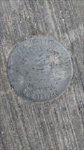
|  Blair Vertical Control - Blair, WI Blair Vertical Control - Blair, WI
in U.S. Benchmarks This disk is on the West end of the bridge on the South side of the road. posted by: mrjcanger location: Wisconsin date approved: 09/19/2016 last visited: never |
 view gallery view gallery E15.8 km E15.8 km
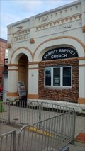
|  121 West Broadway Street - Blair, WI, USA 121 West Broadway Street - Blair, WI, USA
in Converted Bank Buildings Now occupied by Charity Baptist Church, this bank building was built in 1895. posted by: mrjcanger location: Wisconsin date approved: 09/21/2016 last visited: never |
 view gallery view gallery NE28.2 km NE28.2 km
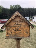
|  Little Free Library of Northfield - Northfield, WI Little Free Library of Northfield - Northfield, WI
in Free Community Book Exchanges Free Community Book Exchange run by the city of Northfield. posted by:  m&m O m&m O location: Wisconsin date approved: 07/31/2021 last visited: never |
 view gallery view gallery S29.6 km S29.6 km
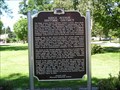
|  Ridge Avenue Historic District Ridge Avenue Historic District
in Wisconsin Historical Markers Ridge Avenue Historic District Marker Galesville, WI posted by: frankhj location: Wisconsin date approved: 04/19/2012 last visited: never |
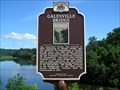 view gallery view galleryS29.8 km | Galesville Bridge in Wisconsin Historical Markers Galesville Bridge Marker in Galesville, Trempeauleau County posted by: frankhj location: Wisconsin date approved: 08/11/2014 last visited: never |
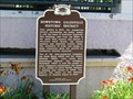 view gallery view galleryS29.9 km | Downtown Galesville Historic District in Wisconsin Historical Markers Downtown Galesville Historic District marker in downtown Galesville in Trempeleau County posted by: frankhj location: Wisconsin date approved: 03/02/2012 last visited: never |
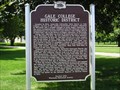 view gallery view galleryS30.1 km | Galesville College in Wisconsin Historical Markers Galesville College Marker in Galesville, Trempealeau County posted by: frankhj location: Wisconsin date approved: 08/11/2014 last visited: never |
 view gallery view galleryNE30.6 km |  McDonalds - Osseo, WI McDonalds - Osseo, WI
in McDonald's Restaurants This McDonalds just off I-94 and HWY 10 on Radcliff St. in Osseo. posted by: REUAHNESIE location: Wisconsin date approved: 07/04/2010 last visited: never |
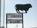
 view gallery view galleryNE30.7 km |  Large Black Cow at Moe's Diner - Osseo, WI Large Black Cow at Moe's Diner - Osseo, WI
in Roadside Attractions This large black cow sits atop a sign for Moe's diner overlooking the highway in Osseo, WI. posted by: onfire4jesus location: Wisconsin date approved: 03/04/2008 last visited: 05/24/2023 |
 view gallery view galleryNE30.7 km |  Large Black Cow at Moe's Diner - Osseo, WI Large Black Cow at Moe's Diner - Osseo, WI
in Elevated Everyday Objects This large black cow sits atop the Moe's Diner Sign at the exit from the highway in Osseo, WI. posted by: onfire4jesus location: Wisconsin date approved: 03/03/2008 last visited: 05/24/2023 |
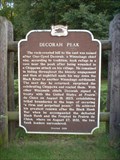 view gallery view galleryS31.7 km | DECORAH PEAK in Wisconsin Historical Markers Across the highway to the east is where Winnebago Chief, One-Eyed Decorah took refuge in a cave near the peak after being wounded in a Chippewa attack on his village. posted by: Archived2012 location: Wisconsin date approved: 09/04/2007 last visited: 06/23/2002 |
 view gallery view galleryS33 km |  Twin Palindrome - Winona, Wisconsin Twin Palindrome - Winona, Wisconsin
in Coordinate Palindromes This palindrome is located in a Trempealeau Marshland Preserve. posted by: annakido location: Wisconsin date approved: 10/16/2006 last visited: 10/30/2007 |
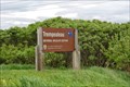 view gallery view gallerySW33.6 km |  Trempealeau NWR - Buffalo WI Trempealeau NWR - Buffalo WI
in National Wildlife Refuges The signs are located along the Great River Rd. The turn off to the VC is Refuge Rd. Easy to miss. posted by: nomadwillie location: Wisconsin date approved: 09/12/2015 last visited: never |
 view gallery view gallery NW33.6 km NW33.6 km
|  Earth home - Modena, WI Earth home - Modena, WI
in Earth Homes Found this gem while on the road less traveled. posted by: Telomere location: Wisconsin date approved: 10/23/2016 last visited: never |
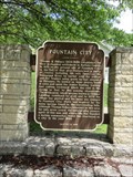
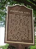 view gallery view gallerySW34 km |  Fountain City Historical Marker - Fountain City, WI Fountain City Historical Marker - Fountain City, WI
in Signs of History This historical marker tells about the background of this area. posted by: wildernessmama location: Wisconsin date approved: 07/06/2016 last visited: never |
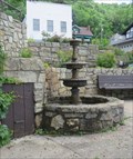 view gallery view gallerySW34 km |  Fountain City Fountain – Fountain City, WI Fountain City Fountain – Fountain City, WI
in Fountains What more appropriate place for a fountain than in Fountain City. posted by: wildernessmama location: Wisconsin date approved: 07/06/2016 last visited: never |
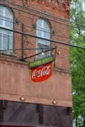 view gallery view gallerySW34 km |  Coca Cola Fountain Service - Fountain City WI Coca Cola Fountain Service - Fountain City WI
in Coca Cola Memorabilia Old Fountain Service sign with Coca Cola prominently displayed posted by: nomadwillie location: Wisconsin date approved: 09/12/2015 last visited: 06/23/2016 |
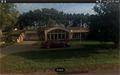
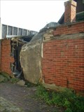 view gallery view gallerySW34 km | Rock in the House - Fountain City, WI in Roadside Attractions On April 24, 1995, a 55-ton boulder suddenly rolled 400 feet down a cliff along the Mississippi River and plowed into this 2-bedroom house owned by Maxine and Dwight Anderson. posted by: Archived2012 location: Wisconsin date approved: 09/11/2007 last visited: 06/23/2016 |
 view gallery view gallerySW34.1 km | Fountain City – Fountain City, WI in Signs of History This historical marker is located at the southern entrance to town. posted by: wildernessmama location: Wisconsin date approved: 07/06/2016 last visited: never |
 view gallery view gallerySW34.8 km | Prairie Moon Sculpture Garden in Roadside Attractions In rural western Wisconsin, on the edge of a lazy tributary of the Mississippi River, stands a colorful art fantasy that enchants adults and children alike. posted by: Archived2012 location: Wisconsin date approved: 09/11/2007 last visited: 06/27/2009 |
 view gallery view galleryE35.9 km |  Bear Rock - North Branch, WI Bear Rock - North Branch, WI
in Simulacra Driving down Hwy 121 between North Branch and Alma Center, one sees off to the north, a large bear's head against a hill. posted by: onfire4jesus location: Wisconsin date approved: 11/24/2007 last visited: 03/05/2013 |
 view gallery view galleryE35.9 km |  North Branch Balanced Rocks - North Branch, WI North Branch Balanced Rocks - North Branch, WI
in Nature's Balanced Rocks As you drive along Hwy 121 in Jackson County, you will see off to the north, a stack of balanced rocks. These are located between North Branch and Alma Center, WI. posted by: onfire4jesus location: Wisconsin date approved: 11/16/2007 last visited: 03/05/2013 |
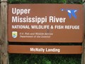 view gallery view gallerySW35.9 km | Upper Mississippi River National Wildlife & Fish Refuge - Mertes Slough - Wisconsin in National Wildlife Refuges Electric motor only area provides a different experience on the Mississippi River. posted by: Refuge Ranger location: Wisconsin date approved: 06/24/2011 last visited: never |
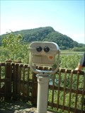 view gallery view galleryS36.4 km |  Perrot State Park Overlook Area Perrot State Park Overlook Area
in Coin-Op Binoculars Located in Perrot State Park at one of the Overlook areas. You will need a park sticker to enter the park or pay a day fee at the Station when you enter the park. posted by: Archived2012 location: Wisconsin date approved: 09/08/2007 last visited: 09/02/2011 |
|