 view gallery view gallery E2.6 km E2.6 km
|   1908 - Canadian Methodist Church - Ebenezer/Marysville, Ontario 1908 - Canadian Methodist Church - Ebenezer/Marysville, Ontario
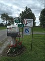
in Dated Buildings and Cornerstones a former Canadian Methodist Church located on County Rd 6/Deseronto Rd in Ebenezer/Marysville, Ontario posted by:  oiseau_ca oiseau_ca location: Ontario, Canada date approved: 08/20/2024 last visited: never |
 view gallery view galleryE2.6 km |  Former Canadian Methodist Church - Ebenezer, ON Former Canadian Methodist Church - Ebenezer, ON
in Methodist Churches Former Ebenezer ON Canadian Methodist Church on Deseronto Road, ON posted by: jiggs11 location: Ontario, Canada date approved: 07/27/2013 last visited: 08/17/2024 |
 view gallery view gallery NE4.5 km NE4.5 km
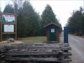
|  Oivi's Nature Trail - Roblin, Ontario Oivi's Nature Trail - Roblin, Ontario
in Self Guided Walks and Trails A hidden jem of a trail system North of Napanee, Ontario on Roblin Road. posted by: mTn_biKer65 location: Ontario, Canada date approved: 11/13/2011 last visited: 08/20/2016 |
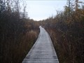 view gallery view galleryNE4.7 km |  Oivi's Trail Non-Coastal Boardwalk - Roblin, Ontario Oivi's Trail Non-Coastal Boardwalk - Roblin, Ontario
in Non-Coastal Boardwalks One of my favorite boardwalks I've traveled on. A really neat experience on a mountain bike with no guard rails. posted by: mTn_biKer65 location: Ontario, Canada date approved: 10/29/2011 last visited: 08/20/2016 |
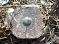
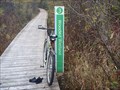 view gallery view galleryNE4.8 km |  Oivi's Trail Permanent Geographic Coordinates - Roblin, Ontario Oivi's Trail Permanent Geographic Coordinates - Roblin, Ontario
in Permanent Geographic Coordinates Permanent coordinates on a trail post at Oivi's Nature Trail at the Menzel Centennial Provincial Park. posted by: mTn_biKer65 location: Ontario, Canada date approved: 10/12/2011 last visited: 08/20/2016 |
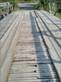 view gallery view galleryE7.2 km |  Plank Bridge over Salmon River - Greater Napanee, Ontario Plank Bridge over Salmon River - Greater Napanee, Ontario
in Plank Roads This plank bridge, known as Partridge Lane, goes over the Salmon River and Salmon River Falls. posted by: Trail Blaisers location: Ontario, Canada date approved: 03/15/2018 last visited: never |
 view gallery view gallery SE7.4 km SE7.4 km
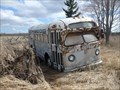
|  1940's GM "Old Style" Bus - Napanee, ON 1940's GM "Old Style" Bus - Napanee, ON
in Abandoned Dead Vehicles Old 1940's-era GM bus silently rusting away near Napanee, ON. posted by: jiggs11 location: Ontario, Canada date approved: 05/07/2017 last visited: 10/02/2020 |
 view gallery view gallery S9.3 km S9.3 km
|  Department of Highways Ontario 20 Department of Highways Ontario 20
in Canadian Benchmarks 401 and Hwy 49 carpool posted by: coman123 location: Ontario, Canada date approved: 03/16/2009 last visited: 04/15/2013 |
 view gallery view galleryE9.7 km |  Sexsmith Cemetery - Napanee, Ontario Sexsmith Cemetery - Napanee, Ontario
in Worldwide Cemeteries a small cemetery located on County 11 Road in Selby, Greater Napanee, Ontario posted by: oiseau_ca location: Ontario, Canada date approved: 08/21/2024 last visited: never |
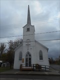
 view gallery view galleryS10.3 km |  Holy Name of Mary - Marysville, ON Holy Name of Mary - Marysville, ON
in Roman Catholic Churches A classic style Roman Catholic church located in rural eastern Ontario. posted by: jiggs11 location: Ontario, Canada date approved: 04/06/2012 last visited: 10/27/2014 |
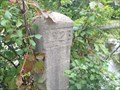
 view gallery view galleryS10.5 km |  Holy Name of Mary Churchyard Cross - Marysville, Ontario Holy Name of Mary Churchyard Cross - Marysville, Ontario
in Churchyard Crosses Located in Holy Name of Mary Cemetery behind Holy Name of Mary Church at 7288 Old Hwy 2, Marysville, Ontario. posted by: mTn_biKer65 location: Ontario, Canada date approved: 04/03/2013 last visited: 06/17/2013 |
 view gallery view galleryS10.5 km |  Shannonville Motorsport Park - Shannonville, ON Shannonville Motorsport Park - Shannonville, ON
in Racetracks Modern, multipurpose racetrack located in eastern Ontario. posted by: jiggs11 location: Ontario, Canada date approved: 06/26/2012 last visited: 05/18/2012 |
 view gallery view galleryE10.5 km |  Pringle Century Farm, Ontario Canada Pringle Century Farm, Ontario Canada
in Century Farms The Pringle Century Farm is located on Pringle Side Road just north of Napanee, Ontario. posted by: Skyecat location: Ontario, Canada date approved: 08/21/2017 last visited: 08/16/2024 |
 view gallery view galleryNE11.4 km |  Roblin-Enterprise United Church - Roblin, ON Roblin-Enterprise United Church - Roblin, ON
in Continental Reformed and Congregational Church Sites United Church of Canada church locatedon Hwy 41 in Roblin, ON posted by: jiggs11 location: Ontario, Canada date approved: 05/29/2016 last visited: 07/22/2017 |
 view gallery view galleryE12.2 km | Selby United Church Former Canadian Methodist Church - Selby, ON in Methodist Churches Selby United Church of Canada, established in 1875 as a Canadian Methodist Church. posted by: jiggs11 location: Ontario, Canada date approved: 09/17/2014 last visited: 08/22/2015 |
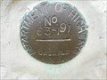 view gallery view galleryE12.2 km | Benchmark 63-191 - Selby, ON in Canadian Benchmarks An Ontario Department of Highways brass disk affixed to the Selby United Church. posted by: jiggs11 location: Ontario, Canada date approved: 09/22/2014 last visited: 08/22/2015 |
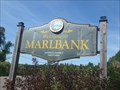 view gallery view gallery N12.9 km N12.9 km
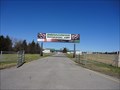
|  Marlbank, ON Marlbank, ON
in Welcome Signs Welcome sign for the Village of Marlbank, ON. posted by: jiggs11 location: Ontario, Canada date approved: 09/23/2016 last visited: never |
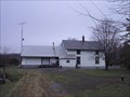 view gallery view galleryN13.4 km |  Marlbank Station - Marlbank, ON Marlbank Station - Marlbank, ON
in Train Stations/Depots Old Marlbank Station on the Bay of Quinte Railway posted by: jiggs11 location: Ontario, Canada date approved: 12/16/2012 last visited: 05/17/2014 |
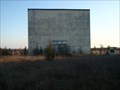 view gallery view gallerySE13.7 km |  41 Drive-In (Napanee Drive-In) - Napanee, Ontario 41 Drive-In (Napanee Drive-In) - Napanee, Ontario
in Closed Drive-In Theatres Located on Drive-In Road West just off Denison Road (Highway 41). posted by: mTn_biKer65 location: Ontario, Canada date approved: 11/14/2011 last visited: 05/05/2018 |
 view gallery view galleryNE13.7 km |  Hell Holes Nature Trails & Caves - Centreville, Ontario Hell Holes Nature Trails & Caves - Centreville, Ontario
in Geological Devilish Locations Located at 420 Barrett Road, in Centreville, Ontario posted by: mTn_biKer65 location: Ontario, Canada date approved: 11/27/2016 last visited: never |
 view gallery view gallery W13.8 km W13.8 km
|  Thrasher Road Bridge - 1923 - Plainfield, ON Thrasher Road Bridge - 1923 - Plainfield, ON
in Bridge Date Stones and Plaques Old bridge on Thrasher Road posted by: stinger503 location: Ontario, Canada date approved: 08/12/2022 last visited: never |
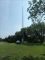 view gallery view galleryS14 km |  KWE Mohawk Radio FM 92.3 - Tyendinaga Mohawk Territory, ON CANADA KWE Mohawk Radio FM 92.3 - Tyendinaga Mohawk Territory, ON CANADA
in Radio and Television Transmitter Towers Transmitter tower located next to the broadcast facility of CKWE-FM Mohawk Radio. posted by: jiggs11 location: Ontario, Canada date approved: 01/26/2018 last visited: never |
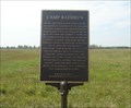 view gallery view gallerySE14 km |  Camp Rathbun - Deseronto, Ontario Camp Rathbun - Deseronto, Ontario
in Citizen Memorials a bronze plaque located on Boundary Road, Deseronto, Ontario posted by: oiseau_ca location: Ontario, Canada date approved: 08/22/2023 last visited: never |
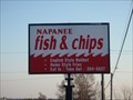 view gallery view galleryE14.2 km |  Napanee Fish & Chips - Napanee, Ontario Napanee Fish & Chips - Napanee, Ontario
in Fish and Chips Restaurants Fish & Chips restaurant on Denison Road (Highway 41) just North of the 401 in Napanee. posted by: mTn_biKer65 location: Ontario, Canada date approved: 11/13/2011 last visited: 09/12/2014 |
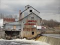 view gallery view galleryW14.3 km |  Chisholm Mill Purina Chows - Roslin, ON Chisholm Mill Purina Chows - Roslin, ON
in Ghost Signs Remnants of Purina Chows signage on old mill, now a lumberyard. posted by: jiggs11 location: Ontario, Canada date approved: 10/24/2017 last visited: never |
|