 view gallery view gallery N3.5 km N3.5 km
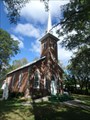
|   Sidney Baptist Church - Halloway, ON Sidney Baptist Church - Halloway, ON
in Baptist Churches Rural Baptist Church located on Baptist Church Road in Halloway. posted by:  jiggs11 jiggs11 location: Ontario, Canada date approved: 10/05/2017 last visited: never |
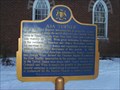 view gallery view galleryN3.5 km |  "Asa Turner" - Halloway, ON "Asa Turner" - Halloway, ON
in Ontario Provincial Plaques OHP relating the life and exploits of Asa Turner, a pioneering Baptist Minister in Eastern Ontario. posted by: jiggs11 location: Ontario, Canada date approved: 01/11/2013 last visited: 07/19/2020 |
 view gallery view gallery S4.5 km S4.5 km
|  Quinte West Fire Department Station # 4 Sidney Ward Quinte West Fire Department Station # 4 Sidney Ward
in Firehouses This firestation is located on the corner of Wallbridge-Loyalist Road and Vermilea Rd in Quinte West. posted by: kenlaur location: Ontario, Canada date approved: 04/09/2012 last visited: 10/08/2012 |
 view gallery view gallery SE4.7 km SE4.7 km
|  Stone Church Hastings - Quinte West, Ontario Stone Church Hastings - Quinte West, Ontario
in Cobblestone Buildings Former Wesleyan Methodist cobblestone building North of Belleville in Quinte West, Ontario. posted by: mTn_biKer65 location: Ontario, Canada date approved: 10/19/2012 last visited: 05/06/2012 |
 view gallery view gallerySE4.7 km | "STONE CHURCH HASTINGS" - Quinte West in Ontario Provincial Plaques One of three cobblestone churches found in Ontario, now houses the Stonechurch Museum of Art. posted by:  Timo Explorer Timo Explorer location: Ontario, Canada date approved: 07/07/2011 last visited: 10/07/2012 |
 view gallery view gallery W4.8 km W4.8 km
|  Drumlin Lookout - Sager Conservation Area - Sterling, Ontario Drumlin Lookout - Sager Conservation Area - Sterling, Ontario
in Look-Out Towers One of the highest lookout points in the area from top of drumlin. Located just south of Stirling off Highway 33 (30 Golf Course Road). posted by: mTn_biKer65 location: Ontario, Canada date approved: 11/09/2016 last visited: 03/20/2021 |
 view gallery view gallery E6.3 km E6.3 km
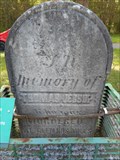
|  Thomas Jessop - Corbyville, ON Thomas Jessop - Corbyville, ON
in Graves Mentioning a Cause of Death Grave marker of Thomas Jessop, who was murdered at Glen Ros Mills, ON. posted by: jiggs11 location: Ontario, Canada date approved: 05/21/2015 last visited: 10/21/2015 |
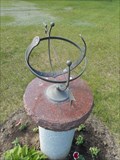 view gallery view galleryE6.3 km |  Sundial - Elmwood Cemetery - Corbyville, ON Sundial - Elmwood Cemetery - Corbyville, ON
in Sundials Armillary sundial located on the grounds of Elmwood cemetery in Corbyville. posted by: jiggs11 location: Ontario, Canada date approved: 05/24/2015 last visited: never |
 view gallery view galleryS7.7 km |  Survey Marker 10 - ON Department of Highways - Belleville, ON Survey Marker 10 - ON Department of Highways - Belleville, ON
in Canadian Benchmarks ON Department of Highways Survey Marker located north of Hwy 401 in Belleville, ON. posted by: jiggs11 location: Ontario, Canada date approved: 11/03/2013 last visited: never |
 view gallery view galleryE7.7 km |  Corbyville Dam- Corbyville, ON Corbyville Dam- Corbyville, ON
in Water Dams Historic dam in Corbyville posted by: stinger503 location: Ontario, Canada date approved: 09/06/2013 last visited: 10/10/2016 |
 view gallery view gallery NW7.7 km NW7.7 km
|  Rotary Covered Bridge - Stirling, ON Rotary Covered Bridge - Stirling, ON
in Rotary International Markers Large boulder engraved with the Rotary symbol and information on the nearby covered bridge. posted by: jiggs11 location: Ontario, Canada date approved: 09/16/2014 last visited: never |
 view gallery view galleryS7.9 km | Ontario Highways Survey Disk - Hwy 401/Wallbridge Rd - Belleville, ON in Canadian Benchmarks Ontario Department of Highways Survey Mark located in the on-ramp island to Hwy 401 eastbound from northbound Wallbridge Road. posted by: jiggs11 location: Ontario, Canada date approved: 03/24/2018 last visited: never |
 view gallery view galleryNW7.9 km |  ROTARY COVERED BRIDGE - Stirling, Ontario ROTARY COVERED BRIDGE - Stirling, Ontario
in Covered Bridges A 1977 35' stringer truss covered bridge spanning Rawdon Creek located in downtown Stirling, Ontario. posted by: mTn_biKer65 location: Ontario, Canada date approved: 05/15/2014 last visited: 09/15/2014 |
 view gallery view galleryNW7.9 km |  Veterans Memorial - Stirling, ON Veterans Memorial - Stirling, ON
in Non-Specific Veteran Memorials Simple memorial to the Veterans from the Stirling area who served, initially in the Great War, now added to include all wars. posted by: jiggs11 location: Ontario, Canada date approved: 11/08/2018 last visited: 06/09/2019 |
 view gallery view gallerySE7.9 km | Survey Marker 171 - ON Department of Highways - Belleville, ON in Canadian Benchmarks ON Department of Highways Survey Marker located north of Hwy 401 in Belleville, ON. posted by: jiggs11 location: Ontario, Canada date approved: 11/03/2013 last visited: never |
 view gallery view galleryNW7.9 km |  Former Bank of Montreal - Stirling, ON Former Bank of Montreal - Stirling, ON
in Converted Bank Buildings Former Bank of Montreal building in the Village of Stirling, ON. posted by: jiggs11 location: Ontario, Canada date approved: 05/26/2016 last visited: never |
 view gallery view galleryNW7.9 km |  Empire Block - Stirling, ON Empire Block - Stirling, ON
in Ghost Signs Ghost sign for the Empire Block in downtown Stirling, built in th early 1900's. posted by: jiggs11 location: Ontario, Canada date approved: 11/12/2020 last visited: never |
 view gallery view galleryNW7.9 km |  Stirling Festival Theatre - Stirling, ON Stirling Festival Theatre - Stirling, ON
in Live Stage Theaters Live community-run theatre in Stirling, ON. posted by: jiggs11 location: Ontario, Canada date approved: 12/06/2014 last visited: never |
 view gallery view galleryNW7.9 km |  1927 - Community Service Building - Stirling, ON 1927 - Community Service Building - Stirling, ON
in Dated Buildings and Cornerstones Former Stirling Community Services Building, now the home of the Stirling Festival Theatre. posted by: jiggs11 location: Ontario, Canada date approved: 01/18/2015 last visited: never |
 view gallery view gallerySE7.9 km | Survey Mark 173 ON Department of Highways - Belleville, ON in Canadian Benchmarks ON Department of Highways Survey Marker located north of Hwy 401 in Belleville, ON posted by: jiggs11 location: Ontario, Canada date approved: 11/03/2013 last visited: never |
 view gallery view galleryNW7.9 km |  Stirling-Rawdon Public Library - Stirling, ON Stirling-Rawdon Public Library - Stirling, ON
in Libraries Community Library in Stirling, ON celebrating its 100th year in 2014. posted by: jiggs11 location: Ontario, Canada date approved: 12/07/2014 last visited: never |
 view gallery view galleryNW7.9 km |  Stirling Public Library - Stirling, ON Stirling Public Library - Stirling, ON
in Carnegie Library Buildings Carnegie-funded public library in Stirling, ON. posted by: jiggs11 location: Ontario, Canada date approved: 12/09/2014 last visited: never |
 view gallery view galleryNW7.9 km | BM 65-540 Stirling, ON in Canadian Benchmarks Vertical BM on side of old Bank of Montreal/Sovereign Bank Branch in Stirling, ON posted by: jiggs11 location: Ontario, Canada date approved: 04/20/2012 last visited: never |
 view gallery view gallerySE7.9 km | Survey Mark 175 ON Department of Highways - Belleville, ON in Canadian Benchmarks Ontario DOH Survey Marker located north of Hwy 401 in Belleville, ON posted by: jiggs11 location: Ontario, Canada date approved: 11/03/2013 last visited: never |
 view gallery view gallerySE7.9 km | Survey Mark 177 - ON Dept of Highways - Belleville, ON in Canadian Benchmarks DOH Survey Mark along service road north of Hwy 401 in Belleville, ON posted by: jiggs11 location: Ontario, Canada date approved: 11/03/2013 last visited: never |
|