 view gallery view gallery E6.3 km E6.3 km
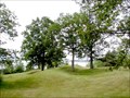
|   Serpent Mounds National Historic Site of Canada, Keene, Ontario Serpent Mounds National Historic Site of Canada, Keene, Ontario
in Canadian National Historic Sites Serpent Mounds First Nations burial site is representative of 60 BC to 300 AD when it was in active use. Serpent Mounds Park is owned and operated by Hiawatha First Nation. The snake like configuration of the mounds is unique in Canada. posted by:  colincan colincan location: Ontario, Canada date approved: 02/19/2009 last visited: 07/17/2009 |
 view gallery view gallery NW7.4 km NW7.4 km
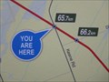
|  You Are Here - Keene Road Access - Lang-Hastings Trail - Assumption, ON You Are Here - Keene Road Access - Lang-Hastings Trail - Assumption, ON
in 'You Are Here' Maps YAH for the Keene Road access point to the Trans Canada Trail/Lang-Hastings Trail. posted by:  jiggs11 jiggs11 location: Ontario, Canada date approved: 05/08/2016 last visited: never |
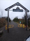 view gallery view galleryNW7.4 km |  Lang-Hastings Trail - Assumption, ON Lang-Hastings Trail - Assumption, ON
in Rails to Trails Access point for the Lang/Hastings Trail, near Assumption, ON. posted by: jiggs11 location: Ontario, Canada date approved: 05/11/2016 last visited: 06/16/2019 |
 view gallery view galleryNW7.4 km |  N 44 16.530 W 078 16.505 - Keene Road - Lang-Hastings Trail, ON. N 44 16.530 W 078 16.505 - Keene Road - Lang-Hastings Trail, ON.
in Permanent Geographic Coordinates Trailhead for the Lang-Hastings Trail, near Assumption, ON. posted by: jiggs11 location: Ontario, Canada date approved: 05/08/2016 last visited: never |
 view gallery view gallery NE8 km NE8 km
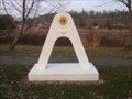
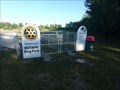
|  Friendship Arch - Lang, ON Friendship Arch - Lang, ON
in Lions Clubs International Markers Friendship Arch located in McIntyre Memorial Park, Lang, ON posted by: jiggs11 location: Ontario, Canada date approved: 11/18/2012 last visited: never |
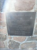
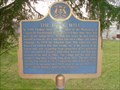 view gallery view galleryNE8 km |  "THE LANG MILL" - Lang, ON "THE LANG MILL" - Lang, ON
in Ontario Provincial Plaques Plaque Describing the 19th century Lang Mill in Lang, ON posted by: jiggs11 location: Ontario, Canada date approved: 11/19/2012 last visited: 08/13/2014 |
 view gallery view galleryNE8.2 km | Red Fife Wheat National Historic Event of Canada, Lang Pioneer Village, Ontario in Canadian National Historic Sites Site of the development of the strain of wheat known as Red Fife, an early maturing high quality spring wheat. Discovered in 1842, this wheat was adapted to the short growing season on the Prairies and facilitated colonization of Western Canada. posted by: colincan location: Ontario, Canada date approved: 02/18/2009 last visited: 08/02/2014 |
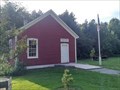 view gallery view galleryNE8.2 km |  Douro, Ontario Douro, Ontario
in City and Town Halls This is a Town Hall for the former Township of Douro, which ceased to exist in 1998 when it merged with neighbouring Township of Dummer to create Township of Douro-Dummer. The Town Hall has been relocated to Lang Pioneer Village. posted by: Trail Blaisers location: Ontario, Canada date approved: 07/22/2019 last visited: never |
 view gallery view galleryNE8.2 km |  Douro Town Hall - Keene, Ontario Douro Town Hall - Keene, Ontario
in Relocated Structures This was Town Hall for the former Township of Douro. It is now one of many relocated structures that form the layout for Lang Pioneer Village. posted by: Trail Blaisers location: Ontario, Canada date approved: 07/21/2019 last visited: never |
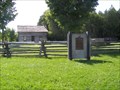
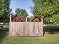 view gallery view galleryNE8.2 km |  Outhouses at Lang Pioneer Village - Keene, Ontario Outhouses at Lang Pioneer Village - Keene, Ontario
in Outhouses Lang Pioneer Museum features 25+ restored and furnished buildings constructed between 1825 and 1899 and these outhouses are directly behind South Lake School. posted by: Trail Blaisers location: Ontario, Canada date approved: 07/21/2019 last visited: never |
 view gallery view gallery SW8.9 km SW8.9 km
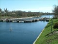
|  Wallace Point Bridge - 1967 - Peterborough, ON Wallace Point Bridge - 1967 - Peterborough, ON
in Bridge Date Stones and Plaques Bronze marker, dated 1967, affixed to the end stonework on the Wallace Point Bridge south of Peterborough. posted by: jiggs11 location: Ontario, Canada date approved: 07/23/2018 last visited: never |
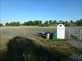 view gallery view galleryNW9.8 km |  Rotary Dog Park - Peterborough, ON Rotary Dog Park - Peterborough, ON
in Off-Leash Dog Areas Huge dog park located in the east end of Peterborough, ON. posted by: jiggs11 location: Ontario, Canada date approved: 06/27/2016 last visited: never |
 view gallery view galleryNW9.8 km |  Rotary Dog Park - Peterborough, ON Rotary Dog Park - Peterborough, ON
in Rotary International Markers Huge dog park located in the east end of Peterborough, ON. posted by: jiggs11 location: Ontario, Canada date approved: 06/28/2016 last visited: never |
 view gallery view galleryNW10 km |  Lock 19 on the Trent Canal Lock 19 on the Trent Canal
in Waterway Locks, Planes and Lifts Lock #19 located in Peterborough on the Trent Canal posted by: biggerilla location: Ontario, Canada date approved: 04/30/2007 last visited: 12/06/2011 |
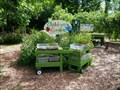 view gallery view galleryNW10 km |  GreenUP Ecology Park Children's Garden - Peterborough, Ontario GreenUP Ecology Park Children's Garden - Peterborough, Ontario
in Children's Gardens GreenUP Ecology Park Children's Garden is located in GreenUP Ecology Park at 1899 Ashburnham Drive in Peterborough, Ontario. posted by: mTn_biKer65 location: Ontario, Canada date approved: 08/11/2015 last visited: never |
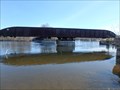 view gallery view galleryNW10.1 km |  CNR Swing Bridge - Otonabee River - Peterborough, ON CNR Swing Bridge - Otonabee River - Peterborough, ON
in Moving Bridges Former CN swing bridge over the Otonabee River near downtown Peterborough. posted by: jiggs11 location: Ontario, Canada date approved: 05/30/2017 last visited: 05/25/2018 |
 view gallery view gallery W10.1 km W10.1 km
|  Reg and Roberta Graham - Peterborough, Ontario Reg and Roberta Graham - Peterborough, Ontario
in Dedicated Benches One of two dedicated benches with a view of the runway at the Peterborough Airport posted by: Bon Echo location: Ontario, Canada date approved: 05/29/2018 last visited: never |
 view gallery view galleryW10.1 km | Frank A Montgomery - Peterborough, Ontario in Dedicated Benches One of two dedicated benches with a view of the runway at the Peterborough Airport posted by: Bon Echo location: Ontario, Canada date approved: 05/29/2018 last visited: never |
 view gallery view galleryNW10.1 km |  CPR Swing Bridge - Otonabee River - Peterborough, ON CPR Swing Bridge - Otonabee River - Peterborough, ON
in Railroad Bridges Former CP Rail swing bridge over the Otonabee River near downtown Peterborough. posted by: jiggs11 location: Ontario, Canada date approved: 06/05/2017 last visited: 05/25/2018 |
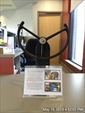 view gallery view galleryW10.3 km |  Link Flight Simulator - Peterborough Ontario Link Flight Simulator - Peterborough Ontario
in Preserved Machines on Public Display The controls from a Link Flight Simulator on display inside the Peterborough Airport Terminal posted by: Bon Echo location: Ontario, Canada date approved: 05/27/2018 last visited: never |
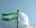 view gallery view galleryW10.3 km |  Peterborough County Peterborough County
in Municipal Flags Peterborough County flag flying outside the Peterborough Airport terminal building posted by: Bon Echo location: Ontario, Canada date approved: 05/22/2018 last visited: 09/06/2018 |
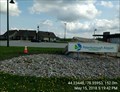 view gallery view galleryW10.3 km |  Peterborough Airport - Peterborough, ON, Canada Peterborough Airport - Peterborough, ON, Canada
in Airports A municipal airport in Peterborough posted by: Bon Echo location: Ontario, Canada date approved: 05/25/2018 last visited: 09/06/2018 |
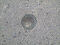 view gallery view galleryNW10.5 km |  Lock and Lansdowne streets Lock and Lansdowne streets
in Canadian Benchmarks A City of Peterborough surveyor marker in the sidewalk. NW corner of Lock street and Lansdowne street. posted by: biggerilla location: Ontario, Canada date approved: 04/30/2007 last visited: 12/21/2015 |
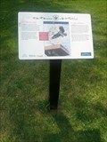 view gallery view galleryNW10.5 km |  The 'fishing eagle' The Osprey - Peterborough, Ontario The 'fishing eagle' The Osprey - Peterborough, Ontario
in Flora and Fauna Information Signs The 'fishing eagle' The Osprey sign is located on the Trans Canada Trail running parallel to Ashburnham Drive in Peterborough, Ontario. posted by: mTn_biKer65 location: Ontario, Canada date approved: 07/28/2014 last visited: never |
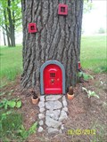 view gallery view galleryE10.6 km |  Red Fairy Door, Elmhurst resort, Keene, Ontario Red Fairy Door, Elmhurst resort, Keene, Ontario
in Wee Folk Fairy Doors Wee folk fairy door is located outside the entrance of the Elmhurst Inn, located in Keene, Ontario on the north shore of Rice Lake. posted by: Skyecat location: Ontario, Canada date approved: 12/23/2017 last visited: 07/28/2019 |
|