 view gallery view gallery NE0.3 km NE0.3 km
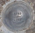
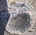
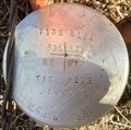
|   QD1534 - NGS X 791, Oregon QD1534 - NGS X 791, Oregon
in U.S. Benchmarks NGS PID QD1534 - NGS Benchmark X 791 posted by:  Volcanoguy Volcanoguy location: Oregon date approved: 02/22/2007 last visited: 02/23/2007 |
 view gallery view gallery W0.3 km W0.3 km
| David Evans & Assoc #2 - Oregon in U.S. Benchmarks Blank David Evans & Associates cap. posted by: Volcanoguy location: Oregon date approved: 11/02/2015 last visited: 11/01/2015 |
 view gallery view gallery SW0.3 km SW0.3 km
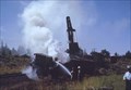
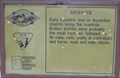
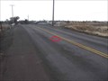
|  1971 Wreck at Deschutes Junction, Oregon 1971 Wreck at Deschutes Junction, Oregon
in Railway Disaster Sites This train wreck occurred just south of the Deschutes Junction siding, about 11:20 pm on July 16, 1971. posted by: Volcanoguy location: Oregon date approved: 02/16/2007 last visited: 02/16/2007 |
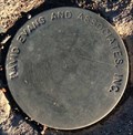
 view gallery view galleryW0.5 km | David Evans & Assoc #1 - Oregon in U.S. Benchmarks Blank David Evans & Associates cap. posted by: Volcanoguy location: Oregon date approved: 11/02/2015 last visited: 11/01/2015 |
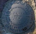
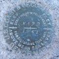
 view gallery view galleryNE0.6 km | QD0835 - USCGS E 30 RESET, Oregon in U.S. Benchmarks NGS PID QD0835 - USCGS Benchmark E 30 RESET posted by: Volcanoguy location: Oregon date approved: 02/22/2007 last visited: 02/23/2007 |
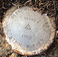 view gallery view galleryW1.8 km | QD1831 - Des. Co. DL130 1941 - Oregon in U.S. Benchmarks Deschutes County Control Survey point DL120. posted by: Volcanoguy location: Oregon date approved: 11/02/2015 last visited: 11/01/2015 |
 view gallery view galleryW1.9 km | QD0832 - USCGS J478 1941 - Oregon in U.S. Benchmarks U.S. Coast & Geodetic Survey benchmark J478. posted by: Volcanoguy location: Oregon date approved: 11/02/2015 last visited: 11/01/2015 |
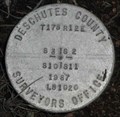
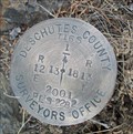
 view gallery view gallery S2.1 km S2.1 km
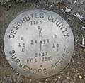
| T 16-17 S, R 12 E, Sec. Cor 34, 35, 2, 3 - Oregon in U.S. Benchmarks Deschutes County Surveyor’s Office section corner. posted by: Volcanoguy location: Oregon date approved: 06/02/2012 last visited: 01/03/2012 |
 view gallery view gallery SE2.3 km SE2.3 km
| T 16-17 S, R 12 E, Cor 35, 36, 1, 2 - Oregon in U.S. Benchmarks Section corner between private land and public land (BLM). posted by: Volcanoguy location: Oregon date approved: 01/21/2020 last visited: 08/19/2019 |
 view gallery view galleryW3.1 km | QD0833 - USCGS K478 1941 - Oregon in U.S. Benchmarks U.S. Coast & Geodetic Survey benchmark K478. posted by: Volcanoguy location: Oregon date approved: 11/02/2015 last visited: 11/09/2015 |
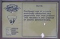 view gallery view gallerySE3.1 km |  Huntington Road - Ruts Huntington Road - Ruts
in Oregon Historical Markers Sign on Huntington Road Interpretive Trail. posted by: Volcanoguy location: Oregon date approved: 02/29/2008 last visited: 02/29/2008 |
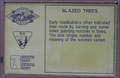 view gallery view gallerySE3.2 km | Huntington Road - Blazed Trees in Oregon Historical Markers Sign on Huntington Road Interpretive Trail. posted by: Volcanoguy location: Oregon date approved: 02/29/2008 last visited: 11/19/2021 |
 view gallery view galleryNE3.2 km |  T16S R12E S24 R13E S19 1/4 COR - Deschutes County, OR T16S R12E S24 R13E S19 1/4 COR - Deschutes County, OR
in Public Land Survey Marks PLSS quarter corner set by Deschutes County Surveyors Office, Kenneth L. Grantham in 2002 posted by: Cooke17513 location: Oregon date approved: 01/27/2014 last visited: never |
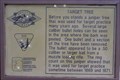 view gallery view gallerySE3.4 km | Huntington Road - Target Tree in Oregon Historical Markers Sign on Huntington Road Interpretive Trail. posted by: Volcanoguy location: Oregon date approved: 02/29/2008 last visited: 11/19/2021 |
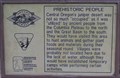 view gallery view gallerySE3.4 km | Huntington Road - Prehistoric People in Oregon Historical Markers Sign on Huntington Road Interpretive Trail. posted by: Volcanoguy location: Oregon date approved: 02/29/2008 last visited: 02/29/2008 |
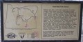 view gallery view gallerySE3.4 km | Huntington Road in Oregon Historical Markers Sign on Huntington Road Interpretive Trail. posted by: Volcanoguy location: Oregon date approved: 02/29/2008 last visited: 11/19/2021 |
 view gallery view gallerySE3.4 km | Huntington Road - Campsite in Oregon Historical Markers Sign on Huntington Road Interpretive Trail. posted by: Volcanoguy location: Oregon date approved: 02/29/2008 last visited: 02/29/2008 |
 view gallery view gallerySE3.4 km | Huntington Road - Artifacts in Oregon Historical Markers Sign on Huntington Road Interpretive Trail. posted by: Volcanoguy location: Oregon date approved: 02/29/2008 last visited: 02/29/2008 |
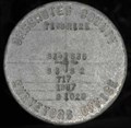
 view gallery view galleryW3.5 km | USGS K-1, Oregon in U.S. Benchmarks USGS Benchmark K-1 set in 1928. posted by: Volcanoguy location: Oregon date approved: 12/28/2005 last visited: never |
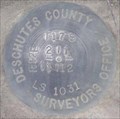
 view gallery view galleryS3.7 km | T 17 S, R 12 E, Corner 2, 3, 10, 11, Oregon in U.S. Benchmarks Deschutes County Surveyors Office cadastral mark. posted by: Volcanoguy location: Oregon date approved: 12/12/2011 last visited: 12/07/2011 |
 view gallery view galleryS3.7 km | T 17 S, R 12 E, Section Corner 1, 2, 11, 12, Oregon in U.S. Benchmarks Cadastral cap for T 17 S, R 12 E, Section Corner 1, 2, 11, 12 posted by: Volcanoguy location: Oregon date approved: 03/06/2008 last visited: 03/06/2008 |
 view gallery view gallery N4.3 km N4.3 km
| T 16 S, R 12 E, 1/4 corner between sections 11 & 14, Oregon in U.S. Benchmarks Cap for T 16 S, R 12 E, 1/4 corner between sections 11 & 14. posted by: Volcanoguy location: Oregon date approved: 02/09/2006 last visited: never |
 view gallery view galleryNE4.3 km | T16S R12E S13 R13E S18 1/4 COR - Deschutes County, OR in Public Land Survey Marks PLSS quarter corner set by Deschutes County Surveyors Office, Kenneth L. Grantham in 2001 posted by: Cooke17513 location: Oregon date approved: 01/22/2014 last visited: never |
 view gallery view galleryN4.5 km | T 16 S, R 12 E, Sec. Corner 10, 11, 14, 15, Oregon in U.S. Benchmarks Cap for T 16 S, R 12 E, Sec. Corner 10, 11, 14, 15 posted by: Volcanoguy location: Oregon date approved: 02/09/2006 last visited: never |
 view gallery view galleryN4.7 km | T 16 S, R 12 E, 1/4 corner between sections 10 & 15, Oregon in U.S. Benchmarks Cap for T 16 S, R 12 E, 1/4 corner between sections 10 & 15. posted by: Volcanoguy location: Oregon date approved: 02/09/2006 last visited: never |
|