 view gallery view gallery SE7.4 km SE7.4 km
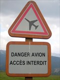
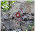
|   Danger avion; Valberg, Alpes-Maritimes Danger avion; Valberg, Alpes-Maritimes
in Unusual Signs Beware of the aeroplanes posted by:  balista balista location: Provence-Alpes-Côte d'Azur, France date approved: 02/03/2010 last visited: 01/11/2011 |
 view gallery view gallery S10.6 km S10.6 km
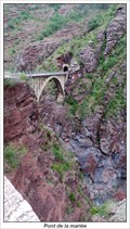
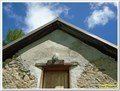
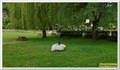
|  Pont de la mariée Pont de la mariée
in French Benchmarks Le pont de la mariée. posted by:  tontonlou tontonlou location: Provence-Alpes-Côte d'Azur, France date approved: 09/15/2013 last visited: 09/15/2013 |
 view gallery view gallery N11.9 km N11.9 km
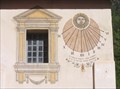
|  Sundials on Penitents Chapel, St Etienne de Tinée Sundials on Penitents Chapel, St Etienne de Tinée
in Sundials A simple elegant happy face sundial on the Penitent's Chapel in St Etienne de Tinée, France posted by: arby101ca location: France date approved: 02/09/2010 last visited: never |
 view gallery view gallery NW17.9 km NW17.9 km
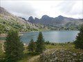
|  Le Lac d'Allos. Provence Alpes Côte d'Azur. France Le Lac d'Allos. Provence Alpes Côte d'Azur. France
in Natural Lakes Le lac d'Allos est lac naturel le plus haut d'Europe avec une altitude à 2228m.
Lake Allos natural lake is the highest in Europe with an altitude 2228m. posted by: fredevils location: Provence-Alpes-Côte d'Azur, France date approved: 10/25/2013 last visited: 03/06/2012 |
 view gallery view gallery W20.6 km W20.6 km
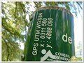
|  44°07'17.8"N 6°38'41.1"E - Cabane de Congerman - Beauvezer, France 44°07'17.8"N 6°38'41.1"E - Cabane de Congerman - Beauvezer, France
in Permanent Geographic Coordinates Ces coordonnées sont sur un panneau à destination des randonneurs posted by: YvesProvence location: Provence-Alpes-Côte d'Azur, France date approved: 06/12/2018 last visited: 09/05/2022 |
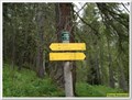 view gallery view galleryW20.6 km |  Cabane de Congerman - Beauvezer, Paca, France Cabane de Congerman - Beauvezer, Paca, France
in Elevation Signs Un poteau de randonnée que l'on trouve derrière la cabane de Congerman, un bon endroit pour le pique-nique lors du tour des Gorges de St Pierre posted by: YvesProvence location: Provence-Alpes-Côte d'Azur, France date approved: 07/12/2017 last visited: 09/05/2022 |
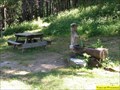 view gallery view galleryW20.6 km |  Fontaine de Congerman - Villars-Heyssier, Beauvezer, Paca, France Fontaine de Congerman - Villars-Heyssier, Beauvezer, Paca, France
in Fountains La fontaine du gîte de Congerman posted by: YvesProvence location: Provence-Alpes-Côte d'Azur, France date approved: 07/22/2017 last visited: 09/05/2022 |
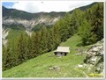
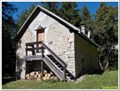 view gallery view galleryW20.6 km |  Gite de Congerman - Villars-Heyssier, Beauvezer, Paca, France Gite de Congerman - Villars-Heyssier, Beauvezer, Paca, France
in Remote Backcountry Shelters Le Gîte de Congerman, au bout des gorges de Congerman. posted by: YvesProvence location: Provence-Alpes-Côte d'Azur, France date approved: 07/26/2017 last visited: 09/05/2022 |
 view gallery view galleryW20.6 km | 1867 m - Cabanes forestières de Congerman - Beauvezer, France in Elevation Signs Une altitude présente au-dessus de la porte de la cabane principale de Congerman (il y en a 3). posted by: YvesProvence location: Provence-Alpes-Côte d'Azur, France date approved: 06/12/2018 last visited: 09/05/2022 |
 view gallery view galleryW20.8 km | 1907 m - Chabanal - Beauvezer, Paca, France in Elevation Signs Un poteau que l'on trouve en haut de la forêt, au nord du circuit de randonnée des Gorges de Saint Pierre, à la bifurcayion pour gagner la cabane de Chabanal. posted by: YvesProvence location: Provence-Alpes-Côte d'Azur, France date approved: 07/12/2017 last visited: 09/05/2022 |
 view gallery view galleryW20.8 km | 44°07'38.5"N 6°38'27.8"E - Chabanal - Beauvezer, France in Permanent Geographic Coordinates Ces coordonnées sont sur un panneau à destination des randonneurs / These coordinates are on a sign for hikers posted by: YvesProvence location: Provence-Alpes-Côte d'Azur, France date approved: 09/05/2022 last visited: 09/05/2022 |
 view gallery view galleryW21.1 km | Maison forestière de Chabanal - Beauvezer, France in Remote Backcountry Shelters La cabane de Chabanal posted by: YvesProvence location: Provence-Alpes-Côte d'Azur, France date approved: 06/15/2018 last visited: never |
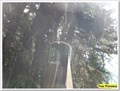
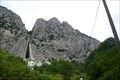 view gallery view galleryS21.1 km |  Les Demoiselles du Castagnet - Puget-Théniers, Vars, France Les Demoiselles du Castagnet - Puget-Théniers, Vars, France
in Established Rock Climbing Areas Demanding Via Ferrata in the steep mountain walls of the Demoiselles du Castagnet at Puget-Theniers. posted by: André de Montbard location: Provence-Alpes-Côte d'Azur, France date approved: 07/06/2017 last visited: never |
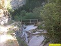 view gallery view galleryW21.2 km |  Pont du fond des gorges de St Pierre, Beauvezer, Paca, France Pont du fond des gorges de St Pierre, Beauvezer, Paca, France
in Hiking Path Footbridges Au fond des gorges de Saint Pierre, on peu traverser le torrent par ce pont avec une seule rambarde. posted by: YvesProvence location: Provence-Alpes-Côte d'Azur, France date approved: 06/12/2017 last visited: 07/05/2019 |
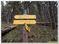
 view gallery view galleryW21.2 km |  Vous êtes ici - Ravin de Saint Pierre - Beauvezer, France Vous êtes ici - Ravin de Saint Pierre - Beauvezer, France
in 'You Are Here' Maps Un panneau destiné aux randonneurs posted by: YvesProvence location: Provence-Alpes-Côte d'Azur, France date approved: 06/12/2018 last visited: 07/05/2019 |
 view gallery view galleryW21.2 km | 44°07'19.8"N 6°38'10.9"E - Ravin de Saint Pierre - Beauvezer in Permanent Geographic Coordinates Ces coordonnées sont sur un panneau à destination des randonneurs posted by: YvesProvence location: Provence-Alpes-Côte d'Azur, France date approved: 08/16/2019 last visited: 09/05/2022 |
 view gallery view galleryW21.2 km | 1561 m - Ravin de Saint Pierre - Beauvezer, Paca, France in Elevation Signs Un panneau d'information comme on en trouve sur les chemins de randonnées posted by: YvesProvence location: Provence-Alpes-Côte d'Azur, France date approved: 07/12/2017 last visited: 07/05/2019 |
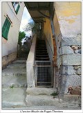 view gallery view galleryS21.6 km | L'ancien Moulin de Puget-Theniers in French Benchmarks Support :
MOULIN
Partie support :
MUR DE FACADE posted by: tontonlou location: Provence-Alpes-Côte d'Azur, France date approved: 04/24/2013 last visited: 04/24/2013 |
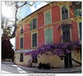 view gallery view galleryS21.6 km | L'hotel au bord de la Roudoule in French Benchmarks Support : HOTEL -RESTAURANT
Partie support : MUR DE FACADE SUD-EST posted by: tontonlou location: Provence-Alpes-Côte d'Azur, France date approved: 04/24/2013 last visited: 04/24/2013 |
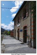 view gallery view galleryS21.7 km | Gare de Puget-Theniers in French Benchmarks Support : GARE DE PUGET-THENIERS
Partie support : MUR DE FACADE SUD, FACE VOIE posted by: tontonlou location: Provence-Alpes-Côte d'Azur, France date approved: 04/22/2013 last visited: 04/24/2013 |
 view gallery view galleryW21.9 km | I'.A.K3S3 - 0-I / 0406101- Colmars, FRance in French Benchmarks Ce point est à la fois un repère de nivellement et un site géodésique posted by: YvesProvence location: Provence-Alpes-Côte d'Azur, France date approved: 08/16/2019 last visited: never |
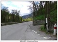 view gallery view galleryS21.9 km | Chemin du Planet in French Benchmarks AU LIEU-DIT "LA COLLETTE", AU-DELA DE LA N.202, PARALLELE A LA VOIE ET AU CARREFOUR AVEC UN CHEMIN
Support : MUR DE SOUTENEMENT
Partie support : FACE CARREFOUR posted by: tontonlou location: Provence-Alpes-Côte d'Azur, France date approved: 04/22/2013 last visited: 04/23/2013 |
 view gallery view galleryS21.9 km | Chemin de fer de Provence in French Benchmarks Support : PONT SUR LE RAVIN DE "LA TRENIERE"
Partie support : PARAPET AVAL, FACE VOIE posted by: tontonlou location: France date approved: 04/22/2013 last visited: 04/23/2013 |
 view gallery view galleryW21.9 km |  Le ciel enfantin - Kees Verkade - Colmars, France Le ciel enfantin - Kees Verkade - Colmars, France
in Figurative Public Sculpture L'oeuvre le Ciel Enfantin de Kees Verkade posted by: YvesProvence location: Provence-Alpes-Côte d'Azur, France date approved: 09/05/2018 last visited: 07/05/2019 |
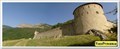 view gallery view galleryW21.9 km |  Fort de Savoie - Colmars les Alpes, France Fort de Savoie - Colmars les Alpes, France
in Historic Forts Le fort Saint-Martin, puis de Savoie, puis fort Desaix (1887), est dû à Richerand, qui dessine les plans, et en dirige l’exécution de 1693 à 1695. posted by: YvesProvence location: Provence-Alpes-Côte d'Azur, France date approved: 08/16/2019 last visited: never |
|