![Image for SNOW AZ MK 2 [CF4903] -- Deschutes County, OR](https://img.geocaching.com/waymarking/small/8d8eb0ba-dac4-4d91-832d-0c76fa6c18c4.jpg) view gallery view gallery E5.3 km E5.3 km
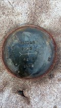
|   SNOW AZ MK 2 [CF4903] -- Deschutes County, OR SNOW AZ MK 2 [CF4903] -- Deschutes County, OR
in Azimuth Benchmarks NGS Azimuth Mark brass cap stamped SNOW 1945 AZ 2 1976, set in a 9x9" concrete monument posted by:  Cooke17513 Cooke17513 location: Oregon date approved: 02/06/2012 last visited: never |
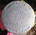
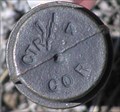
 view gallery view galleryE6.1 km | CF3692 - NGS 'AZ 2' Azimuth Mark - Deschutes County, OR in Azimuth Benchmarks This Azimuth mark is part of the LAIDLAW series of benchmarks and located at the corner of Hwy 20 and Gerking Market Rd. posted by: NW_history_buff location: Oregon date approved: 05/06/2015 last visited: never |
 view gallery view galleryE6.1 km |  CF3692 - NGS 'AZ 2' Azimuth Mark - Deschutes County, OR CF3692 - NGS 'AZ 2' Azimuth Mark - Deschutes County, OR
in U.S. Benchmarks This Azimuth mark is part of the LAIDLAW series of benchmarks and located at the corner of Hwy 20 and Gerking Market Rd. posted by: NW_history_buff location: Oregon date approved: 05/06/2015 last visited: never |
 view gallery view galleryE6.1 km | T 17 S, R 11-12 E, N 1/16 Corner between Section 12 & 7, Oregon in U.S. Benchmarks Cadastral cap for T 17 S, R 11-12 E, N 1/16 Corner between 12 & 7 posted by: Volcanoguy location: Oregon date approved: 07/01/2007 last visited: 07/01/2007 |
 view gallery view galleryE6.1 km | T 16 S, R 11-12 E, 1/4 corner between sections 25 & 30, Oregon in U.S. Benchmarks Cap for T 17 S, R 11-12 E, 1/4 corner between sections 25& 30. posted by: Volcanoguy location: Oregon date approved: 02/24/2006 last visited: never |
 view gallery view galleryE6.4 km | Tumalo State Park Bounday Marker (1), Oregon in U.S. Benchmarks State Park Boundary Marker for park property in Section 7 of T17S, R12E. posted by: Volcanoguy location: Oregon date approved: 06/30/2007 last visited: 06/30/2007 |
 view gallery view galleryE6.6 km | Tumalo State Park Bounday Marker (2), Oregon in U.S. Benchmarks State Park Boundary Marker for park property in Section 7 of T17S, R12E. posted by: Volcanoguy location: Oregon date approved: 07/01/2007 last visited: 07/01/2007 |
 view gallery view gallery SE6.6 km SE6.6 km
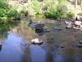
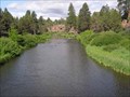
|  CONFLUENCE - Tumalo Creek - Deschutes River CONFLUENCE - Tumalo Creek - Deschutes River
in River Origins, Destinations and Confluences Tumalo Creek flows into the Deschutes River in a 200 foot deep canyon near Bend, Oregon. posted by: Volcanoguy location: Oregon date approved: 06/23/2007 last visited: 06/23/2007 |
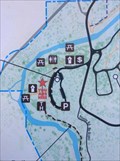 view gallery view galleryE6.6 km |  Tumalo State Park (1) - Bend, Oregon Tumalo State Park (1) - Bend, Oregon
in 'You Are Here' Maps You Are Here marker on trailhead map at Tumalo State Park. posted by: Volcanoguy location: Oregon date approved: 10/31/2017 last visited: 10/28/2017 |
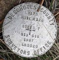 view gallery view gallerySE6.6 km | Section Corner T17S, R11-12E, Sections 12, 7, 18, 13 - 1987 - Oregon in U.S. Benchmarks Deschutes County Surveyors Office section corner T17S, R11-12E, Sections 12, 7, 18, 13 posted by: Volcanoguy location: Oregon date approved: 02/06/2013 last visited: 12/15/2012 |
 view gallery view gallerySE6.6 km | T 17 S, R 11 E, Center 1/4 of section 23, Oregon in U.S. Benchmarks Caps for T 17 S, R 11 E, center 1/4 corner of section 23. posted by: Volcanoguy location: Oregon date approved: 06/09/2006 last visited: 06/10/2006 |
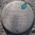 view gallery view gallerySE6.8 km | Tumalo Creek Gage Datum, Oregon in U.S. Benchmarks Stream gage datum on Tumalo Creek. posted by: Volcanoguy location: Oregon date approved: 06/09/2006 last visited: 06/10/2006 |
 view gallery view galleryE6.8 km |  Tumalo Station (#302), Tumalo, Oregon Tumalo Station (#302), Tumalo, Oregon
in Firehouses The Tumalo Station is located in the unincorporated community of Tumalo.
posted by: Volcanoguy location: Oregon date approved: 01/26/2006 last visited: 06/12/2009 |
 view gallery view gallerySE6.8 km | Tumalo State Park Bounday Marker (3), Oregon in U.S. Benchmarks State Park Boundary Marker for park property in Section 7 of T17S, R12E. posted by: Volcanoguy location: Oregon date approved: 07/01/2007 last visited: 07/01/2007 |
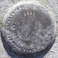 view gallery view galleryE6.8 km | Tumalo Park Bridge BM, Oregon in U.S. Benchmarks Benchmark on bridge across Deschutes River in Tumalo State Park.
posted by: Volcanoguy location: Oregon date approved: 08/12/2006 last visited: 08/12/2006 |
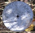
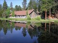
 view gallery view galleryE6.8 km |  Tumalo State Park - Oregon Tumalo State Park - Oregon
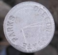
in State/Provincial Parks Tumalo State Park is located on the Deschutes River just north of Bend, Oregon. posted by: Volcanoguy location: Oregon date approved: 06/24/2007 last visited: 06/27/2007 |
 view gallery view galleryE6.8 km |  Deschutes River Trail Boardwalk - Bend, Oregon Deschutes River Trail Boardwalk - Bend, Oregon
in Non-Coastal Boardwalks Boardwalk along Deschutes River Trail in Tumalo State Park. posted by: Volcanoguy location: Oregon date approved: 11/15/2017 last visited: 10/28/2017 |
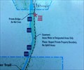 view gallery view galleryE6.9 km | Tumalo State Park (2) - Bend, Oregon in 'You Are Here' Maps You Are Here marker on trail map at Tumalo State Park. posted by: Volcanoguy location: Oregon date approved: 10/31/2017 last visited: 10/28/2017 |
 view gallery view galleryE6.9 km | OSHD BM TUMALO, OREGON in U.S. Benchmarks Oregon State Highway Department benchmark near Tumalo, Oregon. posted by: Volcanoguy location: Oregon date approved: 03/21/2010 last visited: 02/21/2021 |
 view gallery view gallerySE6.9 km |  Shevlin Park - Bend, OR Shevlin Park - Bend, OR
in Municipal Parks and Plazas Shevlin Park (652 acres) is located less than five miles from downtown Bend and a perfect location for hiking, jogging, fishing, cross country skiing and picnicking. posted by: Volcanoguy location: Oregon date approved: 06/09/2006 last visited: 06/10/2006 |
 view gallery view galleryE6.9 km | T 17 S, R12 E, Center 1/4 Corner in Section 7, Oregon in U.S. Benchmarks Point on State Park Boundary for park property in Section 7 of T17S, R12E. posted by: Volcanoguy location: Oregon date approved: 07/01/2007 last visited: 07/01/2007 |
 view gallery view gallery N7.1 km N7.1 km
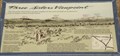
|  WB - Three Sisters Viewpoint WB - Three Sisters Viewpoint
in Oregon Historical Markers Sign at westbound Three Sisters Viewpoint. posted by: Volcanoguy location: Oregon date approved: 10/13/2008 last visited: 01/17/2015 |
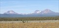 view gallery view galleryN7.1 km |  Westbound Three Sisters Viewpoint -- U.S. Hwy. 20 Westbound Three Sisters Viewpoint -- U.S. Hwy. 20
in Scenic Roadside Look-Outs Three Sisters Viewpoint on Hwy 20 West posted by: Volcanoguy location: Oregon date approved: 10/16/2008 last visited: 01/17/2015 |
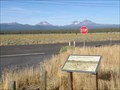 view gallery view galleryN7.1 km |  WB Three Sisters Orientation Table, Oregon WB Three Sisters Orientation Table, Oregon
in Orientation Tables This orientation table is part of the “Three Sisters Viewpoint” sign. posted by: Volcanoguy location: Oregon date approved: 10/13/2008 last visited: 01/17/2015 |
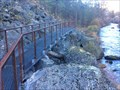
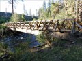 view gallery view gallerySE7.1 km |  Shevlin Park, Lower Bridge - Oregon Shevlin Park, Lower Bridge - Oregon
in Hiking Path Footbridges Lower footbridge in Shevlin Park, west of Bend, Oregon. posted by: Volcanoguy location: Oregon date approved: 09/07/2011 last visited: 08/11/2011 |
|